Stanage

Sunday, 8 November 2015

SEASON OF MISTS AND MELLOW FRUITFULNESS

Yes, autumn is upon us and I give thanks to the poet John Keats and his Ode to Autumn (which I studied for A level English Lit oh so many years ago) for the title of this post.

We've had another break for late holidays, but now we are both back for the forseeable future, and whilst we have been away autumn has snuck up. Sunny, dry days and chilly nights have pushed the trees into showing their glorious firey colours and we are hoping to capture some of this on today's walk.

After a brief debate we decided to head for Cressbrook Dale. It's somewhere we usually visit earlier in the year to see the orchids and wild flowers, but there are plenty of trees so fingers crossed we'll have something worth photographing.

We meet, as usual, at the Monsal Head car park behind the pub, to avail ourselves of the local conveniences, then back to our cars to drive down the steep narrow road into the valley bottom. Already we have lovely views of the golden leaves, but it certainly isn't safe to take photos whilst driving!

The little car park at the side of the River Wye is empty so we pull up and get ready for our walk. And yes, we have plenty of catching up to do so we are talking twenty to the dozen. It is a lovely crisp and sunny day, but we have had rain over the last couple of days so we are not expecting it to be totally dry underfoot, but it doesn't look like rain is a possibility now even though we pack our waterproofs.


We head up the road towards the very smart Mill, admiring the ponies in the fields and the trees on the opposite hill. We take the right hand road at the Mill and start the steady climb upwards. There are some lovely trees here but a good photographic view of them tends to be blocked by others that, so far, have refused to do anything other than stay green.


At the sharp hairpin in the road we walk straight ahead on a wide track which leads to a gate. It's a bit muddy at the far side of the gate, but at least there aren't any cows here - there had been on a previous walk, and I'm not fond of cows.

This field stays reasonably level for a while before decending in a slippery slope to the bottom. At the side of the slope, though, are blackberry bushes and we debate stopping to pick some. But there aren't too many fruit on them, no doubt others have been here before us, so we leave them and carry on. 

At the bottom we slide a little towards the small gated bridge over a completely dry stream bed (but we have seen this flooded and been unable to proceed) and at the far side we are into the woods. Yet again the vivid colour we were hoping for isn't particularly evident here, but that doesn't mean that it isn't a lovely walk. It is. It's a narrow winding path with a few undulations and rocky patches which comes out into the open, sheep and rabbit nibbled valley of Cressbrook Dale. It is completely dry here and with the sun shining it is warm enough to remove layers. 


We walk up the valley until we are beneath Peter's Stone (or Peter's Rock if you prefer) then scramble up to the rocky knoll that sits beside it where we find somewhere to sit for lunch. The sandwiches/salads are of little interest, but the coffee is superb and the buns - fresh cream eclairs - are perfect. We have an excellent vantage point here in the sun so we sit for some time putting the world to rights.

Eventually we descend via the longer, easier slope towards Wardlow Mires, double back on the main track beneath Peter's Stone, and head for the footbridge and stile which takes us up into Tansley Dale. We haven't ever walked up here before, but it is an easy stroll despite it being uphill, and part way up there is a huge warren full of rabbit holes.

At the top we study the map a while before rejoining the path behind a man and wife, and they are making very heavy weather of it. We have to keep waiting for them to get far enough ahead as we are walking much faster. At the next stile the lady struggles to get over then walks on while her husband stands and waits. As we approach the stile he asks if we need help! I give him a curt No Thank You, seething with indignation at his assumption of our ineptitude, and go over the stile in short order. He wanders off to join his struggling wife.


The path goes through a field and soon we are at the field gate onto a lane. The couple are there before us, and standing in the gateway with the gate open, looking puzzled. They are following a guidebook rather than a map, have one small rucksack between them and are clearly not regular walkers but there are signs here so they shouldn't be lost. I tell them we'll close the gate, but they just stand there looking vague, so I pull the gate shut as they shuffle foward. We then turn left along the track which runs between two stone walls and keep our eye open for our next path, which is across some fields. The husband and wife trail along a little way behind us.

Just before the track meets the road there is a stone stile and a footpath sign pointing across the fields. Again, we are over in no time and heading across the field at a good pace, determined to get well in front. We need not have bothered, the couple seem to have continued onto the road which leads to Litton. 

The fields slope down a little, then start to climb giving increasingly good views across Cressbrook Dale. We cross another track, with a very steep stone stile, then we reach the field with the cows. Time to be brave. These seem to be quite young, and a curious Jersey ambles towards other while the others look on with interest. PC takes some photos and I manage to walk past without running. The cows had been clustered around our next gateway but most have them have moved away so our way is clear.


Part way across the next field we turn to admire the view behind us and discover that we are being followed. Keep calm! 

Soon enough we are out of the fields and into the woods at the top of the Cressbrook Dale valley. This is quite a precarious walk, the path has been cleared a bit but although it is narrow it is on a definite slope, and there are still plenty of brambles trying to snag at our legs. 


We pause for a moment to enjoy the view which opens out through the trees to the opposite side of the valley and the rock faces at Wardlow Hay Cop, which look magnificent and very prehistoric. Further along we decide to take the path that goes downhill with the benefit of a stepped section, rather than keep to the high level track, and we eventually find ourselves back on the track near the hairpin bend.

From here it is a steady downhill walk along the road, although there do seem to be a lot of cars all of a sudden, and the return to the car park which is now, understandably, full. And we have time to sit and chat (even more) before making plans for our next walk in a couple of weeks time.

Sunday, 20 September 2015

INTO THE WOODS AND SOMEWHERE DIFFERENT


After our walk last week we decided to go for one that we had done, in part, before but had not managed to complete the whole circuit due to bad weather. With a fair wind and reasonable chance of sunshine we meet in the car park at Baslow before I lead the way to the parking spot near Ramsley Reservoir at Shillito Wood.

There are quite a few cars here today, and we do wonder if there is some kind of organised event going on, but before we have finished togging up a couple of the cars leave and it becomes much quieter. As we remarked last week, this is peak holiday season so we shouldn't be too surprised to see more people about.

We head off 'Into The Woods' (thank you Meryl Streep et al) where the going underfoot is soft and springy. The old cross is on our right as we walk diagonally to the bottom corner where we leave the woods and cross over the road to the gate at the other side.

Almost immediately on our left we see in the grass on of the inscribed artist stones that we have photographed before on our walks. This one is starting to look a little weathered, but the moss growing on it gives it a rugged charm.


We only take a couple of steps before we see a pair of horses and their riders coming towards us along the track at a brisk canter. Prudently we stand to one side but fortunately the riders rein back to a walk as they approach and we pass a friendly 'good morning' before heading on our way.

The track is wide and easy to follow, used by walkers, riders and by woodland management vehicles. Foxlane Plantation and Ramsley Moor are on our left and a little further on there is the steeper slope of Hewetts Bank, but for now the track is fairly straight and level, though a little muddy in a few places. There is a sparse covering of birch trees with denser woodland to the right.


It doesn't take us very long to arrive at the gate onto Car Road (which is a bridleway at this point) and we realise that if we do our planned walk we will be back at the car park in no time. It is time for a re-think, and a quick scan of the map gives us an alternative, so we set off up Car Road towards Unthank then turn left onto the next footpath, which takes us into Smeekley Wood.

The stream on our left is very attractive, and running quite fast. There is also a very convenient fallen tree next to it, so we decide to stop for a coffee break which, naturally, ends up lasting long enough to turn into lunch time. 

Coffee, sandwiches and fat fresh cream scones do nothing for the waistline, but contribute greatly to a sense of contentment and satisfaction.

We spend some time sat on our log before deciding to move off along the woodland path. It is wide enough to follow easily, although these woods are clearly used by locals who know their way and have made myriad shortcuts and small paths that are ready to snare the unwary. We make sure we keep an eye on where we are going with constant references to the map.


These are very attractive woods with streams running through, a variety of trees and some fallen trees too. We wonder if there are bluebells in spring.

As we continue we do spot something on a tree ahead, and as we near it we see that it is Tinky Winky of Teletubbies fame fastened to a tree. Whether he is a lost toy fixed there by a kindly passer-by so that it can be easily spotted by its owner, or some kind of bizarre sacrificial victim, we really couldn't say. Of course, it does set us off remembering children's TV, both of our era and that of our children.


There is a slight hesitation as we consult the map again, we have a gate ahead and a bridge on our right, but the ahead path is the one we need as it skirts Bank Wood and, after crossing meadow, brings us onto Horsleygate Road.


It is only a short walk down Horsleygate Road to Eweford Bridge and from here we decide to take the footpath, marked on the map, which cuts out a huge bend in the road and takes us up towards Unthank and Unthank Hall. However, the start of the path takes some finding, it isn't signed and only a derelict gate hints at the way, and then we have to wade through overgrown brambles and weeds for quite a distance until we cross a rickety stile beyond which walking becomes a little easier. The path still isn't clear on the ground, and an absence (deliberate or otherwise) of signposts mean the map is crucial, but we follow what we hope is the path, through a gate and a couple of fields, eventually climbing slowly upwards.


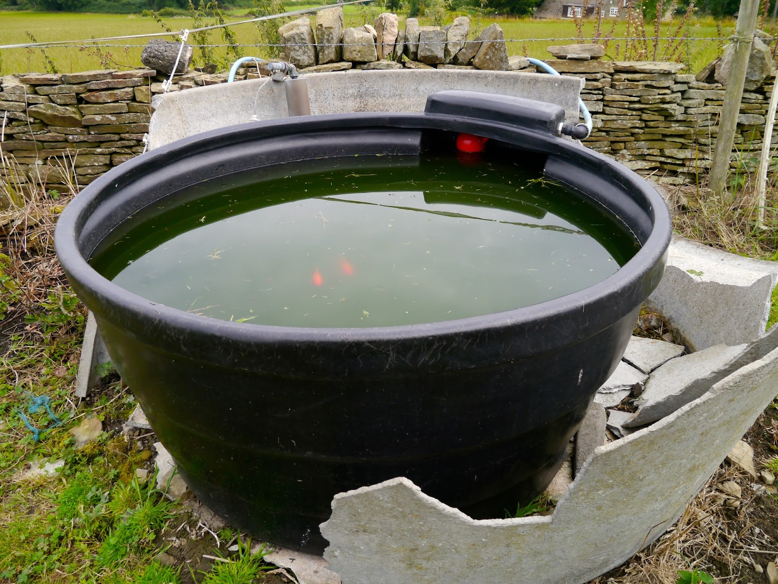
Eventually the way does become a little clearer as another path joins from the right, and we go through fields that are used to graze horses as we head towards the road. Just as we reach it we see an interesting water trough for the animals: complete with goldfish.
We come out onto Unthank Lane across from the Hall, turn right and begin the steady uphill slog along the road and past Burrs Wood. It has become very warm, and quite humid too, so we are soon taking off layers and having to rest. It isn't particularly difficult walking but the combination of heat and humidity soon saps the energy. It's a good job we still have plenty to talk about.
As the road rises up and beyond the wood there are fields to either side of us, and everything becomes very level again. There is hardly any traffic and the circulation of a breeze makes the walking easier. It is a straight road now, taking us to Far Lane where we turn right and come to Shillito Wood again. We pause to admire a 'den' built with branches and sticks, which even has the luxury of a seat inside, before heading back to the car park.

So it hasn't been quite the walk we had originally planned, but it has turned into a better one. The last part was a bit of a slog, road walking always is, and accompanied with the heat and humidity it was never going to be pleasant, but we have had a really good day out and ventured to places we haven't visited before.

How long it will be before our next walk, though, is something we can't plan for just now.

Wednesday, 2 September 2015

TWO CARS, ONE WALK

I can't believe how long it has been since we managed to get out walking. It has been a pretty grim summer for me and this walk, now that PC is back, is the chance for us to catch up and for me to breathe a little. We have a vague plan in mind and meet up at Cutthroat Bridge where, after confusion and discussion, we decide to do the Bamford Edge walk using two cars - one at either end. It's so long since we've walked we both doubt our fitness.

So we pile into my car (I know the way to the parking!) and drive back down the road and turn towards Bamford before taking a left turn and winding upwards on the small road to the pull-in place. Here we have some excellent views of the valley and the hills beyond.

The stile to the start of our walk is immediately on our left and we are soon over it and heading uphill. We have a choice of paths but the 'straight and true'  is the one we choose. We like to get the climbing done early while we still have breath and energy.

The bracken is high but the views are starting to open out. There's a slight haze but we can still see a long way. And we have plenty to talk about.


The heather is in bloom and the hills are swathed in purple. The rugged gritstone of Bamford Edge is ahead of us as we climb a little higher onto the ridge above it. We walk along a little way before descending through the heather and onto Bamford Edge itself. The views from here are spectacular.


Despite it still being the holiday season we have the whole ridge to ourselves and can keep stopping to admire the views, at least, we do when we stop talking for long enough! The purple heather reaches right up to the edge and we soon have views along the reservoirs.

The further we walk the more we can see of Ladybower and of Crook Hill in the distance.


The path dips and starts to fall away from the edge, at the same time becoming narrower and less distinct. There is no proper, official path here, but it is access land and we know where we are heading, more or less. There are a few sheep here too, but they aren't particularly interested in us.


The path takes us to a wall and whilst there is a track beyond it we stop to take stock. It does look vaguely familiar, but not in a good way. We decide to have a quick scout on the path to see if it is the one we want, but we don't have to go more than a few yards to find that all it does is take us across the moor and through thick undergrowth. We back-track and take another narrow path continuing in the direction we had initially been heading. Again, we cross a wall but this time the path is much more promising. Still narrow, and cutting through very high bracken, we follow the line of an unnamed stream that has cut deep into the moor and flows a way below us. We find a crossing point over some stepping stones and head towards what is marked on the map as Pillars. All we can see are two stone built pillars, neither very tall, and a rocky ridge suitable for our lunch stop. We have made much better time than we had expected, although it is starting to drizzle. 

Our course, no walk is complete without buns, and this week, for our first walk back, it is fat choux buns oozing with fresh cream and topped with a swirl of chocolate. They go down extremely well with our coffee after the sandwiches.


After lunch, with the soft rain barely making any difference to us, we continue on our way. The bracken is, if anything, even higher here and the path less distinct. We follow the line of a drystone wall then, at last, it becomes a little clearer. The path keeps to the contour line of the hill, passes by a lone tree, then starts to descend to Jarvis Clough. 

It is a little slippy here, and once we reach the stream we have to make a long stride (with the help of walking poles) to get across. 
Then it is uphill for a short stretch to reach the wide, easy path which will lead us back to the road. It stops raining as we walk along and soon we are at Cutthroat Bridge heading back to the car. All we have to do now is drive back to join car number 1.

The walk has taken far less time than we had anticipated, but it has been an excellent one nonetheless. We are eager to plan for next week too.


Friday, 8 May 2015

AND NOW FOR SOMETHING COMPLETELY DIFFERENT

We couldn't have known as we fought the gales at Castleton that we would be on our last walk of the season. Sadly, we are both of an age where elderly parents cause more loss of freedom than our children ever did, and we have both had to cancel too many times due to the demands of PC's father and my mother.

After much nail-biting and frantic phoning PC finally managed to call someone in to help with her father just before she was due to go out to her boat. So she has escaped. I, alas, have not.

I had been hoping to get out walking for a few days but have been unable to, and this morning seemed to be going the same way. But in the end I decided that I needed to get away, if only for a couple of hours, so instead of the Peak District I headed for the Dukeries, and Clumber Park, which is less than half an hour away.

It is at this time of year that PC always wants to go on a bluebell hunt, so with the sun shining and a small bag packed, I set off with a mission. This walk is for her! (I know she will understand).

I drove into Clumber at the Carburton end; the main road that bisects the park is a national road, known as Lime Tree Avenue, so is free to drive on, though parking anywhere in the park will cost you £6.80 unless you are a NT member (or can avoid the cash collectors on their bikes). Luckily today is a quiet day so even though I park between the trees just off the road there doesn't seem to be anyone about.


I decide to try to bed in my newish boots. I've had them a while but they steadfastly refuse to turn comfortable, and as such I have been wary of using them on anything other than gentle strolls. So on they go - nope, still not comfortable - grab my camera and bag and set off.

Within a couple of minutes I am in the trees on a tiny path, enjoying the silence and the freedom that comes of being alone.
Of course, what I am looking for is that quintessential English spring flower, the bluebell, and from regular walks in these woods in years gone by I know there should be some nearby.

The path takes a couple of turns and then I spot a large clump over to my left. A few paces and I am close enough for some photos.
But I know that the best is yet to come. A little way further along the tiny path meets a larger one, and there in front, and to the right, is the huge swathe of bluebells I have been looking for. They are superb, and the camera cannot even begin to do them justice.
 I stand in the middle of them an inhale the soft sweet scent. It is quite magical.
The flowers are all around me, and a panorama shot is called for.
I find it really hard to give up on the flowers, there is no one around and I wander through the bluebells enjoying the scent, the silence, the feeling of peacefulness. 
It is hard to take my eyes off the carpet of blue at my feet, but when I do I see the soft, zingy-green leaves of new beech trees. Their colour contrasts sharply with the flowers.

Eventually I wander back to the path and set off deeper into the woods. The bluebells are still on my left, along with beech and pine. I hear my first cuckoo too!

The path is straight, easy to follow and completely hemmed in by trees. I know some people find woodland eerie, probably a throwback to tales of Red Riding Hood and the like, but I feel totally at ease here.
A take a right turning and wander along another path. The bluebells are diminishing now but there is still plenty to see. A butterfly decides to accompany me, fluttering alongside, stopping a while, then flying again.
After a while it gets bored of my company and disappears. 

I have a number of tracks to choose from, and eventually take one one my right. Then the cuckoo starts calling again, and this time keeps it up for a considerable length of time. The echoes amongst the trees make it hard to work out where the sound is coming from, at first I thought it was ahead of me but I eventually realise that it is somewhere behind. 

This path is very rough and there are a lot of tall, spindly birch saplings here, replacements for the occasional clearance of older trees. There are a few other trees too, including pine, showing off their young cones.
I am pretty sure that I am not far from the car now, even though the woods have thickened up all of a sudden and the path seems to have diminished into nothing. I look around, spot a clearing through the trees and head for it. Sure enough this clearing opens out and there are a number of paths radiating from it. I get my bearings and walk towards, what I hope is, the direction of the road.

Yes, I'm right. I emerge onto Lime Tree Avenue only a few hundred yards away from my car. I walk between the trees and enjoy the birdsong, the greenery, the sunshine.
I haven't been out for long, and I haven't walked very far, but it has been a much needed and very enjoyable walk nonetheless. With luck on my side I might just manage to get out into the Peak District again sometime soon.


Friday, 10 April 2015

ABANDON HOPE AND ENTER CAVEDALE

The best laid plans have been thwarted again and our promised hike from Hope up Win Hill has had to be postponed. This time, gales, heavy rain, sleet, hail - the works! A power cut where I live means no hot water and, worse still, no coffee. Fortunately a quick text to PC resolves this and she gamely brings along coffee as well as bun, and we also rearrange our walk; we don't want to be on high ground in these winds.

So, with Hope abandoned we decide to meet in Castleton instead and are surprised, given the weather, how busy it is. Already there are groups of bedraggled schoolchildren/Duke of Edinburgh walkers out, along with the Easter holiday-makers. 

As usual we park up on the road just past the Peak Cavern, drag on all our waterproof gear, then set off down the road heading towards Cavedale. 

As soon as we turn up between the houses to the dale entrance we have a taste of what is to come. The tiny lane is awash and the wind is funnelling down strongly. We push on through the gate and start our upward paddle, leaning against the wind. Strangely enough, the photos do not show how wet it really is!


We pause beneath the castle as a group of youngsters ahead of us stop, seemingly lost. Their discussion lasts a while before they set off again, on the only path ahead!


When we reach the spot where the group had been we realise why they had paused. It feels as though all the four winds have congregated in this one spot and it is extremely difficult to move forward. No wonder they were debating whether to go on or not. For us, though, there is no dilemma. We have every intention of forging ahead. I promise PC (without anything to back up my assertions, naturally) that further up the valley the wind will be less forceful. 

As we fight our way upwards against the wind and through a wide stream-bed there is a brief glimmer of sunshine. PC captures it perfectly. It makes the whole landscape look benign and pleasant.


 So, just to put the record straight, and get rid of the idea that maybe we were just making it up about the weather, I have added one of my own photos (from my phone) below. Yes, the river is the footpath!


As we climb up Cavedale against the tide (it certainly feels that way) the wind does actually lessen although there seems to be more and more water. It cascades over the limestone in a manner that would undoubtedly have made Capability Brown jealous, although he would probably have made the path around it rather than through it.

Eventually we make it through the gate at the top, relieved to have made it over the worst of the river-cum-path. A natural spring is gushing from the woods a little lower down on our left and beyond it is relatively dry (relative to the downpour and soggy ground). We pause to admire the view, have a nip from the secret flask as a reward, then press onwards.

It is nearing lunchtime so we decide to find somewhere sheltered to have food. It isn't easy, but eventually we managed to huddle up behind some rocks that give us sufficient protection from the wind. We are very close to the path, sadly, but that can't be helped. 

My first hot drink of the day (thank you, PC) goes down extremely well, then we follow with sandwiches and, joy of joys, yummy buns and a drink (it's my birthday walk, and PC is treating me!). The buns are fantastic, fat choux buns with fresh cream and sticky chocolate icing on top. And the drink is fizz. Bliss.
A surprising number of walkers come past us, most just say a quick hello, but one couple have no idea where they are or where they are going. The have come up from Castleton, they tell us (no, really!) but wonder where the path leads and if they can get back to Castleton, and how far, and where do they go, and how far have they come and how long will it take.........the questions go on. They have no map, no food, nothing to drink (they tell us with a kind of misplaced pride) and are hoping we will provide directions and instructions. We do the best we can and send them on their way whilst refraining from telling them to be better prepared next time.

The wind is still keen but the rain has stopped by the time we have finished lunch, so we carry on up the valley along the gentler, wide path. It is quite muddy in places and when we come to one of the gates we are in for a paddle. Mollie is the only one who is happy about it.
We continue ahead, avoiding the mud, then veering to the left where the wide swathe of the path climbs up. It is well walked (this is the Limestone Way, after all) but still grassy. As we reach the top of the rise the wind hits us again with renewed force. We are walking into it and feel as though we are pushing against treacle.

Through the gate and we turn right, then right again heading towards Winnat's Pass. The group of hikers we had remarked on earlier (and seen a couple more times) are at a standstill again close to Rowter Farm. It looks as though this time we might be in danger of catching up with them, but they set off again.

However, a few hundred yards later and they are, once more at a standstill. This time we do catch up and overtake them; a group of older teens debating their route. However, there isn't much choice, other than straight ahead.

They follow us to the end of the lane and as we open the gate to get onto the road they decide to take the stile. Seems a waste of energy, especially since they appear to need to stop every few hundred yards or so.

We turn right and head for Winnat's Pass, the group disappear to who-knows-where. The wind is behind us now but at least the rain has stopped.


It is a familiar walk down the winding Pass, and we keep to the left hand side where there is a path behind a wall. Slippery in places over the worn limestone it is important to be cautious.

Once through the gate at the bottom and onto the wide verge running alongside the road we realise that this might be the hardest part of the walk. The whole verge is a sodden mass with running water and slippery mud. PC has her walking poles which she needs to keep herself upright, and I eventually step onto the road with Mollie as it seems the safer option.
With the wind behind me I find myself being pushing into a jog, PC is quite surprised as I pass her but anything we might say to each other is whipped away by the gale.

Eventually I make it back onto the verge, steady myself against the wind which is pushing like crowd of schoolchildren trying to get onto the bus home. When PC catches up we round a small outcrop in the hope that it will protect us. It affords little help, and there is even more water here.

And then it happens: my turn to bite the dust - or rather, the mud and slush. A combination of wind, mud and rain has me on the skating rink to nowhere. I'm not hurt, fortunately, but it is a struggle to get enough purchase to stand up again, even with PC's help. 

No harm done, so we continue carefully down the slope towards the Speedwell Cavern car park. From here there is a pavement to lead us safely back to the cars. However, looking over our shoulders we see a storm coming, and our final stroll becomes a rush to get back before it reaches us. 

Hail and sleet, driven by the battering gale, hits just as we are getting into the cars. Within a couple of minutes the windscreen is white rimmed and visibility is down to a couple of hundred yards. It would be safe to say that we have made it back in the nick of time.

Saturday, 4 April 2015

HOPE TO CASTLETON - VIA STONEHENGE!

So we have managed it again; the worst possible day sandwiched between two glorious walking days. Rain, heavy cloud, wind and snow on the hills greets us as we park up in Hope and rapidly adjust our plans for the day.

Instead of heading up the Edale valley and onto the Win Hill ridge we choose instead to take a circuit along Hope Valley towards Castleton. Suitably dressed for the conditions (full waterproof gear, gloves and hats) we take the road at the side of the church, wary of the heavy lorries that thunder down this narrow road on their way to the cement works.

There is a footbridge over the river here which keeps us off the road, and we pass the old Pinfold on our right. A short climb up the road and we spy the footpath sign on the opposite side of the road. Across we go just as another huge lorry lumbers down the hill. We are glad to be out of the way.

The path is clear here, and fenced off from the adjacent fields, which means that we can let Mollie have a short stretch off the lead. She immediately picks up a stick (log!) and tries to persuade us to play with her. Nope, not going to happen. We are following the small, fast flowing river (is it big enough to be a river?) called Peakshole Water as we make our way towards the railway line.


Both PC and I are certain we have walked this way before, but neither of us can remember crossing the railway! Clearly our memories are playing tricks on us; either we have never walked here before, or we have forgotten a major part of the walk. (And looking back at the blog list I can't find it! Maybe we only thought we walked here.)

We reach the crossing, descend a few steps and, seeing that the amber lights are not flashing, proceed to cross. A couple are stood at the side of the line, waiting, and remark that they thought a train was coming. If they had read the sign (amber flashing lights mean a train is approaching, no lights = no train) they would have been well on their way but instead they stand there, slightly confused. They may be in for a long wait.

The next part of the walk crosses sheep fields, some of which have recently been spread with muck. They are fragrant, to say the least, but at least the footpath area is relatively clear. There are also a fair number of stiles on this stretch, either awkwardly high ones that require a fair amount of agility (which, sad to say, Mollie does not seem to possess in abundance), or narrow ones that necessitate great sucking-in of stomachs! 

It is not an unpleasant stroll, though, providing you discount the rain, and we are soon on the edge of Castleton. The path becomes a little muddier, then skirts a farmyard before emerging onto the road. Here we turn right, and a little way along cross over to the take the footpath heading straight towards Losehill Hall.

As we walk up the path PC notices something in the adjacent field, partly screened by trees and a high drystone wall. It is a replica of Stonehenge - along with a roundhouse. Bemused to find this in the middle of Derbyshire we nevertheless admire it. PC attempts to find a good spot to take photographs then, as she wonders aloud how on earth Losehill Hall managed to get this construction past the Health and Safety police, a sudden gust of wind sends one of the massive 'stones' rolling through the site like tumbleweed. We have our answer. Polystyrene - or something similar. Well, we were fooled! Though it was certainly very well done, painted to look like real, rough-hewn stone and undoubtedly great fun for those staying at the Hall.


At the top of the track we turn right and keep going until we come to Spring House Farm. Here we do a left turn, then right onto the footpath behind the stables. Mmm, this is clearly the bad part of the walk; boggy, muddy and deep puddles. We squelch and paddle our way though, watched by ponies in the next field, then once out of the mire we cross through the hedge line to see a sign telling us to take the path on the drier side of the hedge! Wish we had known that at the other end.


From here we are crossing grassy fields that, in places, are quite slippery, though none as wet as before. And, as luck would have it, the rain has stopped and the sun is even trying to shine. Behind us the views are lovely, and in front of us lies Hope. Unfortunately, though, we are unable to find somewhere suitable to have our lunch, which is long overdue and we are already feeling very hungry.


We come to a choice of two paths, and although they both seem to lead to the same place (they do!) we decide to follow the one with the yellow footpath arrow on it. PC goes first, and as I try to persuade Mollie to go through the kissing gate I hear PC make a soft exclamation and look up to see her on the floor. She says it was a graceful slide down rather than a fall, and I believe her. She is rather muddy though.


As soon as we are across the field and through the exit we realise we could have avoided the slippery patch - ah well, live and learn. We are close to the outskirts of Hope now, and there are small groups of teenagers walking past - probably Duke of Edinburgh students (Who else would be out walking on a day like this? asks PC. Er, us, actually.)


We come to a bridge over the railway, it dips ominously in the middle although it must have been constructed that way, but the sign saying no more than 20 people on the bridge at once makes us pause to wonder. 

At the far side the next stile is a broken, ramshackle and quite dangerous affair with a deep, steep sided muddy puddle at the far side. From here, though, it is a fairly easy walk crossing numerous small fields, into Hope. 

We come out adjacent to the school, make our way to the Edale Road then it is a short walk back to the cars.

It is late for lunch, but we have no intention of missing it. Once divested of our muddy outerwear we settle down in the car to superb coffee, sandwiches and fresh cream eclairs. It all tastes wonderful, probably because we have worked up such an appetite. 

By the time we are ready to leave the sun is out and the last vestiges of snow have melted. We are hoping to meet here again next week to do the walk we originally intended. Fingers crossed.