Tuesday, 23 February 2016
CUTTHROAT BRIDGE AND PAST THE GROUSE BUTTS
Again we opt for a familiar parking spot which is quite busy, although it is the school holidays and looking like it is going to be a good day.
With the sun shining we set off down the main road; a bit of a trial with only a narrow path at the side of the A57 to keep us out of the path of the hurtling traffic, but we soon make it to the crossing place at Cutthroat Bridge.
We go through the gate at the side of the bridge and the first thing we notice is the amount of rubbish dumped next to Ladybower Brook. Plastic boxes, bags, all sorts. Some people don't deserve to come into the countryside.
We go up the rocky path then drop down to the so-called ford over the fast flowing water of Highshaw Clough. Mollie leaps back and forth a few times before we find some stones to cross over dry-shod, then we climb up the short slope and onto the path that runs parallel with the main road.
There is an old waymarker stone on this path (mentioned on a previous post), just after the rather high ladder stile, that indicates that this was once the main route from Sheffield.
Now there are just fields and sheep, and a few walkers like ourselves and the couple behind us with their two dogs. The sheep are not impressed.
Before the path meets Moscar House we turn left (fortunately through the gate, the stone stile looks a bit too intimidating) and start the long but fairly gentle climb up onto the moor and the access land.
There are wonderful far-reaching views here, and we are making such good time that we decide to find a boulder and stop for a coffee. And a nip from the secret flask. Today's treat: vanilla vodka.
We debate staying around for lunch, we are in a lovely spot with the sun shining down on us, but we decide to move on and lunch later.
It's a steady walk up the hill and there are quite a few people about though, fortunately, not too many. There are grouse aplenty though, clearly the shooters haven't had them all. The grouse butts are fenced off which is a shame, in poor weather they do provide a handy refuge for walkers.
We reach the top south of the Wheel Stones where there is a signpost and a choice of routes. Instead we step forward a little way to enjoy the splendid views of the Derwent Valley and Ladybower.
Even as we walk along the ridge the views are still superb, although the weather is starting to close in a little.
Lunch beckons so we take a narrow track off towards the Hurkling Stones. There's quite a brisk breeze blowing now and it will be good to eat out of the wind.
We settle down with sandwiches, coffee and today's bun: apple and cinnamon muffins. They are very big and one of my favourites, but I bought them yesterday and they are better fresh. But they still go down well, and Mollie enjoys finishing off the crumbs.
By the time we have finished it is starting to look a bit grim and we suspect the odd flake of snow to be blowing on the wind. We descend down to Whinstone Lee Tor and take the left hand path back along the moor.
This always tends to get muddy, especially down nearer its bottom reaches, and today is no exception. We meet a small group who make a great fuss of Mollie, which she loves, then we are off again, glad not to be just setting out as they are.
We retrace our steps down to Cutthroat Bridge and across the road as the clouds gather. By the time we get to the cars there is a very fine drizzle falling, not enough to soak you through but enough to make it unpleasant, especially when coupled with the wind. So we are feeling pretty smug that we have missed it and enjoyed a largely clear and sunny walk.
Wednesday, 2 September 2015
TWO CARS, ONE WALK
So we pile into my car (I know the way to the parking!) and drive back down the road and turn towards Bamford before taking a left turn and winding upwards on the small road to the pull-in place. Here we have some excellent views of the valley and the hills beyond.
The stile to the start of our walk is immediately on our left and we are soon over it and heading uphill. We have a choice of paths but the 'straight and true' is the one we choose. We like to get the climbing done early while we still have breath and energy.
The bracken is high but the views are starting to open out. There's a slight haze but we can still see a long way. And we have plenty to talk about.
The heather is in bloom and the hills are swathed in purple. The rugged gritstone of Bamford Edge is ahead of us as we climb a little higher onto the ridge above it. We walk along a little way before descending through the heather and onto Bamford Edge itself. The views from here are spectacular.
Despite it still being the holiday season we have the whole ridge to ourselves and can keep stopping to admire the views, at least, we do when we stop talking for long enough! The purple heather reaches right up to the edge and we soon have views along the reservoirs.
The further we walk the more we can see of Ladybower and of Crook Hill in the distance.
The path dips and starts to fall away from the edge, at the same time becoming narrower and less distinct. There is no proper, official path here, but it is access land and we know where we are heading, more or less. There are a few sheep here too, but they aren't particularly interested in us.
The path takes us to a wall and whilst there is a track beyond it we stop to take stock. It does look vaguely familiar, but not in a good way. We decide to have a quick scout on the path to see if it is the one we want, but we don't have to go more than a few yards to find that all it does is take us across the moor and through thick undergrowth. We back-track and take another narrow path continuing in the direction we had initially been heading. Again, we cross a wall but this time the path is much more promising. Still narrow, and cutting through very high bracken, we follow the line of an unnamed stream that has cut deep into the moor and flows a way below us. We find a crossing point over some stepping stones and head towards what is marked on the map as Pillars. All we can see are two stone built pillars, neither very tall, and a rocky ridge suitable for our lunch stop. We have made much better time than we had expected, although it is starting to drizzle.
Our course, no walk is complete without buns, and this week, for our first walk back, it is fat choux buns oozing with fresh cream and topped with a swirl of chocolate. They go down extremely well with our coffee after the sandwiches.
After lunch, with the soft rain barely making any difference to us, we continue on our way. The bracken is, if anything, even higher here and the path less distinct. We follow the line of a drystone wall then, at last, it becomes a little clearer. The path keeps to the contour line of the hill, passes by a lone tree, then starts to descend to Jarvis Clough.
It is a little slippy here, and once we reach the stream we have to make a long stride (with the help of walking poles) to get across.
Then it is uphill for a short stretch to reach the wide, easy path which will lead us back to the road. It stops raining as we walk along and soon we are at Cutthroat Bridge heading back to the car. All we have to do now is drive back to join car number 1.
The walk has taken far less time than we had anticipated, but it has been an excellent one nonetheless. We are eager to plan for next week too.
Sunday, 23 June 2013
A CIRCUIT OF BAMFORD MOOR
Of course, the week leading up to PC's arrival had been bright, sunny and summery. The day of our planned walk dawned grim, dim and rainy. But undeterred we were still raring to go.
PC looks healthy and tanned (obviously not been in Britain, then) but had missed the moors and paths of the Peak District. She'd also missed proper English tea so had used up all her milk. Good job I have brought the coffee.
We meet at one of our familiar spots, the layby near to Cutthroat Bridge just above Ladybower, and we have a plan. Since we don't have Mollie with us today (too short notice to plan to bring her) it means we are free to roam on the access land leading across Bamford Moor to Bamford Edge. We've only done this once before, years ago (we tried once before that when the moor was first opened but the belligerent gamekeeper of the day considered a miniature poodle on a short lead to be a great threat to his game birds and turned us back before we got very far). Back then we did struggle to beat our way through the thick heather to our destination. This time we're hoping to be luckier.
We walk down the side of the busy A57 and take the stile next to the gate leading onto the access land beneath Hordron Edge. We're on a clear track (frequented by gamekeepers and shooters) taking us gently through thin coniferous woodland which shields the moors from the road. It is so good to be out again, even if it keeps trying to rain.
Immediately we notice how much noise there is from the birds. We hear curlews and a cuckoo almost straight away, and there are others that we cannot identify. The track continues beneath Hordron Edge and when we come to the next woodland copse we see a bird up on the rocks to our left. I eventually manage to take a photograph, but although the bird is silhouetted against the light its long pointed beak is obvious. Is this the noisy but elusive curlew?
We continue along the track enjoying the chance to catch up on all that has happened in the last few weeks. It seems an age since we were last walking and apart from a few emails we haven't had the opportunity to exchange gossip. All that is changing!
As the track starts a gentle upward incline above the stream running down from Jarvis Clough we see a narrow but fairly distinct path on the opposite side. Recalling our problems on our previous walk, and the lack of any kind of path through the thick heather, we decide to drop down to the stream, cross over and follow the path.
We settle down on some flat stones at a broken section of the wall and pull out the secret flask. The Ramblers Restorative tastes wonderful, as does the Old Jamaica chocolate.
We have good, if rather murky, views across the Derwent Moors whilst behind us we can see (if we turn around) Stanage Edge. We have barely finished our drink and chocolate when the rain starts again, and this time it seems to mean it. We pack up quickly and pull on our waterproof trousers and coats before setting off again, keeping roughly to the line of the wall and the path.
The rain doesn't last long and by the time we have reached the rocks marked Pillars on the map the sun has come out and we need to remove the waterproofs as we're in danger of providing ourselves with our own greenhouse effect.
It is fairly easy walking, and the path is clear enough for us not to have to struggle through the heather. So far we haven't seen another soul out walking.
Before long we come to more rocks and decide to find somewhere comfortable for lunch. Once settled we pull out our food, and enjoy our buns (a cinnamon swirl danish and an apricot danish - we split them in half so we can have a taste of each) and a convivial drink of coffee. It is so good to be sat here enjoying the fresh air, views and company that we are most reluctant to get going, and we linger for quite a while. Eventually though we must move on and we pick up the path again.
 As we reach the vehicle track that runs from the grouse butts to the main track another walker strides across the moor and passes us without saying a word. We allow him his space and follow him at a distance. When we reach the main track we see him striking off across Moscar Moor towards Stanage Edge, but we decide instead to take the route over Hordron Edge where there is a large amount of bird activity. We spend a while trying to capture shots of them in flight but don't have much success.
Further along we see another man and realise that he is at the stone circle known as the Seven Stones of Hordron. He scowls at us as we approach, refuses to answer a friendly 'hello' then sits on one of the stones with his arms folded, glaring. As we look at the stone circle and start to take photographs he snatched up his bag and stalks off. Phew. Glad I didn't see him when I was walking alone.
The stone circle is about 16m in diameter and there are about 23 of them in total, if you count all of the smaller ones as well as the main ones. It is in a superb position with the hills and edges forming an amphitheatre around it.
Once we've finished looking around we continue along Hordron Edge then drop down towards the road. Sadly there is a taught wire fence at the edge so no short cut, instead we walk down to the conifer wood, reach the main track then go down to the stile. It's only a few minutes now and once we've walked up the side of the busy road we're back at the cars.
It has been an amazing day. Despite the promise of rain we've only had one wet spell and that didn't drench us. We've enjoyed a long satisfying walk and even been and seen places we've not ventured to before.
Once the wedding is over PC will be back to the ocean waves, and I'm keeping my fingers crossed that family trials and tribulations will ease allowing me to get out again.
Thursday, 22 September 2011
WE'RE BACK WITH A GENTLE AMBLE AND A SPRINT FINISH


Thursday, 10 March 2011
HIGH WINDS, RAINBOWS AND EXTRA BUNS
 It's a late start this morning due to an accident on the M1 which has closed the motorway and sent all it's rush hour traffic my way, doubling my journey time. Still, the sun is shining - or it was when I set out, but by the time I manage to meet up with PC I've driven through a number of heavy showers and the sky isn't quite so bright any more. And there's a strong breeze blowing. Not that it will stop us.
We trudge down the busy roadside to the familiar Cutthroat Bridge and go through the weighted gate which is being swung on its hinges by the wind. Ominous.
Our route takes us along the footpath heading NE so our first obstacle is Highshaw Clough, an attractive stream running down to join Ladybower Brook. The difficulty is in the rocky drop down to its crossing point, which we achieve with a reasonably amount of agility and no witnesses. Once on the far side of the brook we pause on a wall for a quick break. A nip from the secret flask (Ramblers Restorative) and custard tarts. They're not our usual high calorie fare - those buns come later - but a treat is needed after the long haul to reach here, and they do a wonderful job of replenishing our enthusiasm and sugar levels.
Off we go again at a good pace. The track is well defined and easy to follow, and once we have scrambled over a large ladder stile we know why. At the far side of the stile, nestling in the protection of two walls, is an old stone milepost: Sheffield on one side, Stockport on the other.
 We wonder if this track was, in fact, the old 'main road' or turnpike. It seems highly likely. During the reign of William III an Act was passed stating that in remote or rural areas signs should be put up for travellers as they were often unable to ask for directions. Back i the 1700s it would have been the middle of nowhere, and a signpost would have been more than welcome. There is another milepost further along the A57 which is, in fact, Grade II listed! I can't, however, find any more information on this lovely example.
Once past the milepost and across some boggy ground we go through a gate, turn N then NW onto a track that takes us up onto the moors. As soon as we manage to ascend a few feet the wind hits us, rolling off the moors like a wave and hammering us in the face. It's as though it wants us to turn around, which we do, but only briefly to admire the view back towards Stanage Edge and to fasten up our coats.
Walking along this relatively easy gradient is like ploughing uphill through treacle. With every strep we're not only having to contend with the slope, but the relentless and ever increasing force of the wind. For once we're grateful for the grouse butts that line this walk and we stagger from one to another seeking a few moments respite from the elements. At least it isn't raining, and the few light showers trying to fall are whipped away before they can make any impression on us.
This is a 'heads down and trudge on' kind of walk, but being forced to stare at the ground only means that PC sees something she thinks interesting.
 Shouting at me (she has to shout to be heard over the wind) to "Look" I peer at what I think, at first, is a large leaf then realise to my horror that it's a frog sunning itself. I make a rapid detour to avoid it as PC hunkers down to take a photo and chides me saying, "It's not a man-eating frog, you know." But you can't be sure, not out here, in the wilds!
In our next refuge (grouse butt) we see, far below, a large group staggering up in our direction. Some poor school kids being dragged out on a field study - today of all days. Poor them. We decide to head away from the path for a while as the group is bound to move faster than us and eventually catch us up, which we don't want so close to lunch time.
We cross the brown, springy heather and shelter behind a tall, turf-topped wall which is clearly another place for shooters to hide before bravely filling small birds with lead shot.
But as we sit down we're grateful to be out of the wind (more or less) while the sun is shining and there's a brilliant view to enjoy.
We empty the last dregs from the secret flask (that didn't last long) then enjoy a coffee before tucking into our sandwiches. Then we fetch out second buns. Fresh cream scones, something of a stalwart on our many walks, and they are always enjoyed. They're followed by another coffee which, since the wind has sneakily turned, is in danger of being blown out of the cups. We're liberally splattered with coffee flavoured spray - talk about storm in a tea cup.
Suitably full and in danger of needing an after-lunch nap, we pack up our things and head back across the heather towards the path, our way guided by a tall standing stone which, when we approach it, appears to be a natural feature.
The track isn't as steep here but that's just as well because the wind is, if anything, getting stronger. It's taking a huge effort to make progress and otherwise unnoticed leg muscles are beginning to complain.
Close to the top we see three people coming along the broad ridge from our right, reach the moorland cross-roads then choose to descend down to the Ladybower valley. It's a sensible option but not one we can take as we turn left to head South along Derwent Edge.
If we thought it was windy before, we were mistaken. It's gale force up here. We're forced to lean into it just to keep standing and it's impossible to make ourselves heard. Looking down to Ladybower reservoir we can see angry white-tipped waves on its inky surface.
When we look up we can see, rolling in from the direction of Alport, a grey curtain of heavy rain heading towards Derwent Edge, but we judge that it's going to miss us, thank goodness. But as we watch its rapid progress a rainbow appears behind the massive Wheel Stones and arcs all the way towards Bradfield. Magical. Somehow PC manages to take some photos despite the wind trying to rip the camera out of her hand.


We head off again, fighting for every footstep. We can only every remember it being as windy as this once before on a walk, and that was years ago when we were on Stanage Edge, and had to come down before we were blown down. Fortunately the wind isn't blowing off the edge here so we're relatively safe, but it's little comfort whilst trying to cross rocky ground.
The path dips slightly and, absurdly, the wind drops to almost nothing. But we can hear it thundering against the rocks of the edge. I think it sounds like waves crashing into a rocky coastline, PC reckons it sounds more like helicopters coming in to land. It's probably a cross between the two.

As soon as we leave the calm of the dip we're forced back into the gale. At the Hurkling Stones we decide to skip the path completely and head across the heather and short cropped grass to meet our return path. Going downhill with the force of the wind behind us is a bit like moonwalking, and suddenly a gust takes my feet from under me and I sail gracefully (honest) through the air and land quite gently, cushioned by the wind that toppled me. Getting up isn't easy, but I'm unhurt. I wonder if it counts as unaided flight!

On the path the walking is easier. The wind is behind us and its strength lessening slightly as we descend. Three bikers come up the path towards us, very macho and very determined. We wish them luck as they pass. Ten minutes later they cycle down behind us, and as they pass they admit that they couldn't cope with the wind. Can't say we blame them. But why didn't we ask for a piggy-back down the slope. What a missed opportunity.
By the time we reach Cutthroat Bridge again it is only mildly breezy. It's hard to imagine how bad it is up at the top. At least we've made it, although we expect some aching muscles in the morning.
As we drive away from our rendezvous point the heavens open and the rain falls. But it doesn't matter now. Excellent timing all round.
Friday, 22 October 2010
STRINES, FOULSTONE ROAD, BACK TOR, LOST LAD, DERWENT EDGE, WHINSTONE LEE TOR, CUTTHROAT BRIDGE
 We trudge along the road wondering if we'd overdone the layers, and soon we're in the sleepy hamlet of Strines and wonder, is it actually big enough to be called a hamlet?
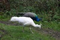


Barely past the few houses we almost walk into two male peacocks, their iridescent blue feathers glorious the early morning light. Naturally, by the time PC has her camera ready the birds had run for cover in a corn field. We wait. Patience pays off as a peahen and her chick emerge,which entices the males from cover. Then even more arrive, including a white one. Now we have plenty of photos and as we walk away we decide that the peacocks must outnumber the hamlet's inhabitants.


