Stanage

Sunday 17 July 2011

END OF SEASON CHALLENGE - THE GRINDSBROOK HORSESHOE


OR: UP HIP AND AWAY.....


It's hard to believe that this is to be the last walk of our 'season'. School holidays put an abrupt end to our walking although we'll both be putting one boot in front of the other albeit separately and in different locations.


So, for our Grand Finale we meet up in Edale. It's a choice spot for high summer walks because of the long days, the large choice of routes and - hopefully - good weather. Today we seem to be in luck as despite a few dodgy clouds looming on the way here we seem to have lost them and the sun is shining out of an impressively blue sky. I'm even wearing shorts - scary!


We've decided to head up Grindsbrook and discuss our route as we walk. Normally we take the popular track up to the head of the Clough then make the steep climb up to the top, and once we even went up the Grindslow Knoll route (never again), but this time as we stride into the meadow after crossing the bridge over Grinds Brook and clambering up the steep steps at the other side, we choose to turn right on the path that climbs up towards The Nab, Ringing Roger and the edge of the Kinder Plateau.


The grassy path starts to climb immediately and we're soon feeling warm, and not just because of the sunshine. Soon the grass gives way to an eroded path which, in turn, leads us to a gate in the wall. Once through this we're really on the long haul upwards. The path has been laid over with stones because, no doubt, of severe erosion and we consider that a pretty good job has been done. The 'steps' are fairly even and of a reasonable stride length which makes climbing up so much easier. The path takes a sharp left and we continue to follow it as it zig-zags its way up the hillside. Naturally we keep stopping to admire the ever-widening view over Edale and the Great Ridge beyond.


When the path suddenly becomes easy, rather than be elated we tread suspiciously, and sure enough our suspicious thoughts are confirmed. Ahead lies the steep, eroded and rocky clamber up Ringing Roger. Of course, we could go around, there is a lower path, but we're making excellent time and aren't feeling even slightly weary, so onward it is.


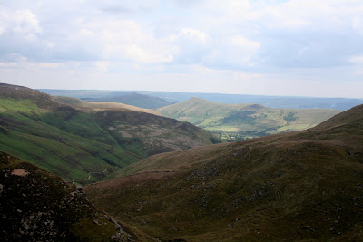
Naturally, it isn't too easy. The erosion and loose stones make it a bit of a challenge, but it's well worth the effort and soon we've made it around the top and onto the path leading to the head of Golden Clough. Standing on the path overlooking the deep valley of Grindsbrook below, feeling the wind in our hair and the sun on our faces is one of the magical moments that makes us get out walking whenever we can.


It's only a short haul up to the very top now, and again the path has been paved against erosion though not as sensitively as at the bottom as some of the steps are high, others low making you walk unevenly. Still, it's a little matter once we're on the top and walking across Nether Tor.


The path is level and almost sandy with tiny pebbles of quartz scattered all around. The views are spectacular and some of the rock formations amazing. There are huge slabs of almost flat rock, then tortured, wind-sculpted monuments.


When we arrive at the superb rock formation called Hartshorn we manage to squeeze down out of the wind and threatening clouds to sit for lunch whilst enjoying the dizzying view.


Since it's our last walk the buns are really special and summery: shortcake pastry, creme anglaise and fresh strawberries. Funny how we go silent when we're eating something so nice!


The clouds are moving fast, changing from dark grey to white to grey again, so it's off with the sunglasses and on with a fleece as we leave our lunch spot and continue on our way. We've decided by now that we're going to go the for complete horseshoe. After all, going down the rocky wall at Grindsbrook Head isn't something we were particularly looking forward to and we don't reckon we'll lose much, if any, time going the slightly longer route.

The path meanders a bit in places to avoid having to cross deep water run-off from the plateau, although at time time of year there is barely a puddle or two to negotiate. We have to do a little bit of rock climbing (OK so we'd not picked up the 'easy' path but hey, no problems) and we're soon at Grindsbrook Head. No, we're definitely not going down that way.


As we walk around the top of the Head and photograph the mushroom shaped rock the sun comes out again and the grey clouds have disappeared. Wonderful.


It's an easy enough walk up to Grindslow Knott although PC decides to skirt around its side rather than go straight over the top, but the views from the top are amazing. There's a whole 360 degree panorama that no amount of photographs can do justice to. There's also splendid views of the far ridge we've just walked too.


Next is the descent, and the first bit can be a bit tricky although we manage well enough (utilizing hands, feet and bums) but it reminds us, as if we needed it, why we don't walk up this way any more. It is steep on the way down, and pretty relentless. Although really it is fairly easy it can make the legs ache.


Soon enough, though, the gateway is in sight and we're walking through the grassy sloping fields towards Grindsbrook Booth. The last section of the path is beneath a canopy of trees, then we're out on the road again and heading down to the car park at Edale.


It's been a marvellous walk to end a marvellous season. Little did we imagine back in the Winter when PC had her hip replacement that we'd be doing anything as good as this so soon. We'd both thought that a route such as today's would be out of the question for at least another year, but we're both pleased to have been proved wrong.


So that's it until September. Over the summer we might be able to get around to putting some more photos on the blog, or some details of older walks (and the Missing Wood), but we'll also be out walking, just not in the Peaks.


Happy Holidays.

Wednesday 13 July 2011

LOSE SOME - NOT QUITE A CIRCUIT AND NOT COMPLETELY DRY


We're doing something very sensible for this walk, although we tend to consider it a bit of a cheat. We meet up at the base of Winnats Pass, abandon one car, transfer rucksacks, walking gear and bodies (ours) into the other car, then drive to Hope where we park and get ready to walk.


We start off along Edale Road which is narrow enough to provide some close encounters with a few passing vehicles, but it's the kind of easy, level walking that's just right for warming up the muscles.


Just before we reach Townhead Bridge we take the left hand track which leads, not surprisingly, to Townhead and, ultimately, Lose Hill. We pause to admire a garden's flourishing patch of Bears Britches (Acanthus spinosus) before pressing on up the gentle incline. As we come to a fork in the track, and knowing we need the left hand path, we see a group of half a dozen teenage lads sorting out their gear. On seeing us they hurry up and continue on their way, no doubt expecting to outstrip us easily. We expect them to outstrip us easily too.


We pause to remove a layer, it is warm and despite a few smatterings of rain we don't want to don waterproofs, then continue up hill. A short while later - and it is a short while - we reach the stile which takes us onto an enclosed track. The stile is decorated with half a dozen resting teenagers. We can almost hear their groans of horror as they pick up their rucksacks and stagger over the stile as we wait for them to get a move on.


We give them a couple of minutes start before we follow. The track feels very old, hollowed out by the passage of many feet with banks at either side and arching trees meeting overhead like the soaring columns of a natural cathedral. We have splendid views across the valley and can clearly see the line of the old Roman Road on the opposite hill.


It's a steady pull up this track and we pause a number of times to admire the view - and to let the boys ahead get out of the way. They are really very slow.


Eventually we see the top of the track where, once through a gate, the path emerges onto open moorland in the final pull up to Lose Hill. When we pass through the narrow gate we find the boys laid out on the damp grass looking rather the worse for wear. We, naturally, nimbly skip past them and power up the next patch of ground, just to show them how it should be done.


We pause to admire a stand of foxgloves (yes, and to get our breath back, we're not made for power-walking) then continue to meander up the very steep hill. We're above the trees here and the views are extensive, reaching all the way along the first loop of the Edale valley. We do keep looking back, still no sign of the boys.


Naturally, we have a few pauses on the way uphill, no point in rushing and missing the view. After a while the boys come into range again, only for them to all collapse in a heap once more. This sorry sight is repeated a few times on the way up. They obviously didn't have their Weetabix for breakfast!


We, on the other hand, are making excellent time, so we decide to stop and have a drink and a bun. Ah yes, it's turned into a double bun day purely by accident. It's PCs turn for coffee, but she wasn't sure so brought buns as well - just in case. Being my turn for buns I'd brought buns and had also remembered to fill the secret flask (with the last of the Ramblers Restorative, I must make some more). So we sit and enjoy a nip from the flask, some coffee and a fresh cream scone.


(Whilst doing so the boys - after another rest 20 yards south of us - manage to stagger past us to rest, again, 20 yards north of us. They eat lunch in almost total silence, the lack of noise suggesting they have little breath left for talking.)


Dark clouds are looming so we decide to press on - having ascertained that the boys have already gone before and have a good enough lead for us not to catch up with them again. It was beginning to get embarrassing - for them!


As we reach the final stile on the route to the summit we do the sensible thing and pull on our waterproofs. The wind is starting to make itself felt and the dark clouds are racing across the sky. It all looks very dramatic.


Sure enough, the heavens open, but not for long. We could have managed without the waterproofs, but now they're on we'll leave them for a while. The sky hasn't cleared and we could be in for more rain.


By the time we reach the summit of Lose Hill we have a magnificent 360 degree view around us, including of Win Hill, the Great Ridge and Mam Tor, Castleton, and the less than impressive cement works. And the sun is shining too. This is what walking is all about.


Descending from the summit is quite direct and height is lost quickly. The path is fenced in by post and wire on one side and a semi-dilapidated stone wall on the other. For some odd reason there are large way-marking cairns at the side of the path, pretty pointless as it would be almost impossible to lose your way on this part.


As we cross the ridge we can see the dark clouds gathering again at the head of Edale and the telltale signs of rainfall at Grindsbrook. Then it all turns very eerie. As the rain starts to sweep down the valley the cloud drops and everything is completely obscured behind a sheet of white.


Its like looking through a fog, or a blizzard, but turning eyes right we can still see bright sunshine at the other end of the valley.


Then the rain hits us. Wow, it really means it. Thank goodness we'd kept out wet-weather gear on as we definitely need it. It's still pouring as we start our decent of Back Tor but thankfully it starts to ease off as we pick our way down the rocky hill being especially careful now that it's turned slippery.


By the time we reach the bottom the rain has stopped and we climb over the stile as the sun breaks out again. And when the sun shines it really is warm, and a bit steamy too.


It's been a while since the bun stop so we find a good place for lunch using some flat stones on top of the dry stone wall. It's very comfortable with a good view down to Castleton, although it isn't that easy to pick out the castle. After sandwiches, though, we decide to carry on before having coffee and second buns (do we sound like Hobbits?) so we walk to Hollins Cross narrowly missing a group of teenagers (no, not the same ones - they've disappeared off the face of the earth) then take the path down towards the base of Mam Tor.


Eventually we find a comfortable mound to sit on where we while away the time drinking coffee and eating fresh cream chocolate muffins. We feel as though we deserve them. In the distance we see yet more school groups enjoying the great outdoors and down on the Castleton Road, there are at least half a dozen coaches parked, with probably more in the main car park. It seems as though every school trip, Duke of Edinburgh outing and groups of Lost Boys has congregated here today.


We check our watches and realise that we need to get a move on. We dispense with the waterproofs, the sun is out and everything has warmed up dramatically, and we make our way over a couple of boggy patches to the remains of the old road, most of which has been destroyed by the Shivering Mountain.


As we walk down the road to car number one (narrowly avoiding being run over by a coach) we start to sniff. Not because we have a cold, or hayfever, but because there is a wonderful, sweet smell. We study the hedgerows, peer over walls - nothing. Then inspiration strikes. Plucking a clover flower we discover the source of the perfume. Red and white clover on the sparse grass verges are almost impossibly fragrant. Neither of us have ever been aware of the sweet smell of this common weed.


All too soon we're back in the car and driving through the heaving main road of Castleton towards Hope where we're reunited with car number two. It's been an excellent walk and it's been a good way of doing it. We'll have to cheat a little more often.