Stanage
Showing posts with label Youlgreave. Show all posts

Sunday, 26 January 2014

ALPORT,ROBIN HOOD'S STRIDE and A STONE CIRCLE


We're back, but it has been a bit hit and miss (more miss, to be honest) and we're tackling this at our second attempt.

We meet in the layby at Alport, the pretty village close to Youlgreave, and as we pull on our layers we catch up with all the news since before the New Year. It seems forever since we were last out!

The weather has been pretty grim these last few weeks so we are hoping that we haven't picked a walk that is too muddy. We have been on part of the route in the past, but much of it is completely new to us so we don't really know what to expect.


We set off down the road and cross to post a letter before taking some pictures of the river, then take the path at the side of the red telephone box. The path is broad, and firm, but there are some large puddles.

In a field adjacent to the path are two very noisy, bossy geese who seem to be less than pleased to see us. PC chats to them as she tries to persuade them to pose for a photo (yes, honest) but I eye them warily and am glad that we aren't any closer.

The path follows the course of the River Lathkill (or is it now the River Bradford?) and we pause to admire the attractive packhorse bridge 


over the water before we press on. The path leads us to the road in Youlgreave at the start of Bradford Dale (and another attractive bridge) 


but instead of crossing over the road and entering the Dale we turn left and walk up the road a little way. There is an old stone building in the field to our left, and just beyond it a signpost pointing across the field for the Limestone Way. This is the one we want.

To say that the Limestone Way is one of the major Derbyshire walking routes we are quite surprised to find that the path across this field, and subsequent ones, is not heavily used. It is well signed, though, which is an advantage when crossing fairly featureless fields.


We do have a couple of sections of mud and waterlogged ground to tip-toe through, and when we come to Bleakley Dike we find that one of the rickety stepping stones to the stile-gate is completely submerged beneath fast flowing water. Good boots a necessity!


There is an uphill stretch here, but with excellent views behind to the village of Youlgreave if you care to pause and look. Ahead of us is a ploughed field which we are not particularly looking forward to crossing.

In the end the ploughed field isn't quite as bad as we had feared - the farmer has 'reinstated' the path but it is still extremely claggy underfoot and at the far end we have to spend a while remove excess mud (and weight) from our boots.

Around the next bend in the path we have yet another wet and muddy section to negotiate, and a choice of routes. The Limestone Way turns sharply left to enter an unnamed wood, whereas the other path takes us through Harthill Moor Farm and adjacent to Castle Ring, and ancient earthwork. We decide to follow the Limestone Way so avoiding the farm, even though we don't have Mollie with us today.

The wood is quite dank and it is chillier here, not that we would call it particularly warm in the open. Still, we spy some rocks which look inviting enough to sit and have a drink (a nip of Ramblers to keep the chill at bay) and a huge triple chocolate chunk cookie to keep up going until lunchtime.

It is too cold to sit for very long so we continue on the path and reach a minor road where we decide to turn right, continuing on the Limestone Way, since we are well ahead of time. There is a farmer muck-spreading in a field at the top of the lane, but fortunately not in the field we plan to cross.


We spot what looks like some standing stones away to our left, and also have our first glance of the very impressive Robin Hood's Stride which we are now keen to visit. 


We debate as we walk as to whether the stones are standing stones, a stone circle or the remains of a farm building, but we check the map and after a while they come into clearer view and they are, without doubt, a very impressive stone circle.


There are four stones standing (the highest in Derbyshire) but are called the Nine Stones Close. We don't walk up to them as there is no Public Footpath to them, and with the farmer busy close by we decide not to risk being caught trespassing, though they may be worth a visit at another time.

Ahead of us the most impressive rocky outcrop called Robin Hood's Stride (also known as Mock Beggar's Mansion or Hall) with its two pinnacles (Weasel Pinnacle and Inaccessible Pinnacle). 


Naturally we clamber up and around it, and finally sit on the rocks close by with a wonderful view of the outcrop while we have lunch.


The sandwiches are typically boring but we have a small bottle of vino to help them down (long story, but not a celebration) and after the wine we have ginger muffins which are suitably gingery and sticky. The warming coffee is more than welcome after our lunch, and with the sun shining it is very tempting to stay for while, but we must press on.


We return to the path which is gouged deep between the Stride and the area which leads to Cratcliffe Crags. It is still the Limestone Way and is probably the route of the old Portway. We plan to return another day to explore the side near Cratcliffe Crags, and to find the Hermit Cave there.


The path is taking us downhill towards the road (B5056) and the worst part of this walk. We have no alternative but to walk along the roadside until we reach our return path, and there are no pavements or even grass verges to use as escape route on what turns out to be a very fast and quite busy road. Also, the sun has gone in casting us into gloom. Not pleasant, but at least we don't have Mollie with us as she hates traffic.

We pass the turning the Birchover and continue until we spot the Bridleway sign across the road, and go onto the path gratefully. It is very muddy across this field but we are pleased that we don't have to paddle across Ivy Bar Brook since there is a double bridle-gate and bridge.

From here it is uphill, and slippery. Where the path narrows it is extremely churned up by cyclists and it is hard to keep our footing. Clearly no horses have used this track for a while as the overhanging hedgerows wouldn't allow mounted riders (or anything other than small ponies) to pass safely.

At the top we come out at a gate and cross a large sheep field with clear lines of old ridge and furrow ploughing. Sadly the lack of sun means there aren't any shadows cast so our photos come out flat rather than interesting. Shame.


The farmer has very kindly put large, round sheep feeders right in the middle of the path, and many little sheepy feet have managed to turn the area around them into a quagmire. Lovely! Still, we soon reach the gate onto the road and cross over another field towards Lower Greenfields. We pass a few old caravans that seem to have been disused for some time, then once on a firm track we pass a small, neat caravan site. What an attractive holiday spot.

The lane continues gently downhill and soon we find ourselves (as planned - always a relief) on the track next to the river on the way back to Alport. A short stroll now (and an absence of geese this time) and we are back at the cars.

The weather has turned dark and gloomy, it will undoubtedly rain later, but we have succeeded in having a very good walk and opened up new possibilities for us in the future.




Tuesday, 24 December 2013

BEYOND YOULGREAVE AND THROUGH LATHKILLDALE

Well, the weather isn't too brilliant for today's walk, it is damp and foggy, but we are hoping for things to clear up later. But the first obstacle isn't so much the weather as actually meeting up.

Our plan, which seems eminently sensible when you look at the map, is to meet in the car park at the end of Moor Lane which leads out of Youlgreave. Simple, you'd think. Not so.

I'm the first to arrive by virtue of being the map reader and having a decent sense of direction, but it was touch and go. Moor Lane is a tiny offshoot from the main road in Youlgreave, easily missed unless you are expecting it and only signed with a hand painted sign. The narrow street I drove up looked as though it was someone's private driveway, then when I turned right onto the main lane I was greeted with a narrow lane and a sign saying 'Quiet Road'. To cut a long story short, it was an interesting drive and I was lucky only to encounter one car coming in the opposite direction (driven by an elderly gentleman who looked, quite frankly, scared and lost) and wasn't surprised to be first to arrive in the deserted car park.


To cut a long story short, it takes a few phone calls (thank goodness for modern technology and mobile reception) and hastily garbled directions (and a couple of chapters of my book as I wait) before PC manages to reach the car park a little late but in one piece and relieved not to have met any other traffic.
We're late setting off, but we're undaunted. We're Mollie-less until after Christmas so we only have ourselves to sort out, and we dress ourselves in our waterproofs from the outset as we doubt that the weather will clear much.
PC worries that the day won't produce many decent photos - there is the prospect of good views from the edge of the car park on a clear day, but all we see is murk - so she starts snapping straight away.
We walk down the 'quiet lane' and haven't gone far before a farm lorry comes rumbling up behind us! We both scale the grass bank at the side of the road and thank our lucky stars that we didn't meet it when we were driving. Once the lorry has passed we continue down the road, pause to photograph a statuesque tree which is posing grandly, then meet a footpath on our left which crosses a couple of grassy fields to another road (Back Lane).


Across the road we take the next footpath which, again, crosses fields. One thing that becomes immediately apparent is that the stiles around here are not terribly forgiving! Many are high off the ground for their first step meaning a good leg stretch for all but the long limbed, then fairly high too. No matter though. We're coping without any trouble and the weather has improved slightly too.
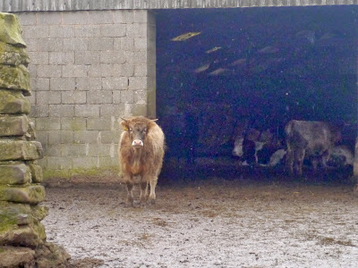
It is a fairly straight path, punctuated only by stiles, downhill towards Meadow Place Grange, a large farmyard. The current farmhouse is a Grade II listed building dating from the 18th century, but the original grange farm belonged to Augustinians of Leicester Abbey until the dissolution of the monasteries. Today it is still a working farm, and as we paddle along the muddy path towards the very high stile - which we clamber over with grace and dignity (naturally) - we realise that it isn't long since the inhabitants of the field passed this way too. Sure enough, at the other side we see cattle inside a large barn, and one cow in particular seems very interested in what we are doing.
 
We cross through the farm yard (fortunately, not so muddy now) and take the path directly opposite which climbs gently through a grass field before bringing us to the top of Meadow Place Wood.
The downhill path between the trees is a bit slippery in places, but soon we are approaching the River Lathkill and the footbridge adjacent to the ford. A group of hikers are sat around having lunch (is it that time already?) but we press on and onto the path which runs along the length of the Dale.
It seems very murky and gloomy in the Dale, although the recent rain has meant that the river is high. We have been here in the past when there has been no water at all, but not today. There are hardly any people about, not surprising since the weather has turned damp again. It doesn't encourage people to get out and we suspect many people will have hung up their boots for the winter. 

It is a pleasant enough walk along Lathkill Dale, even if the weather is grim, and we are able to talk about all sorts of things. One thing we do notice, though, is the amount of broken and shattered timber left over from last week's gales. Glad we weren't here then.
We are getting peckish but there aren't very many stopping points to eat a picnic, especially in the rain. The one place we were hoping to stop (opposite the path we will need later) is already occupied so we walk a little further until we find a comfortable ledge of limestone on which to sit.
We need a small drink of Ramblers first, and this is the last of the batch. Good job I have another bottle at home ready for straining. From the Ramblers we move onto coffee to warm us up before we start on the sandwiches. There's not a lot to say about sandwiches (other than they are very welcome) as it is the bun that excites our interest. Today they are muffins, with cream and a 'spiced fruit compote'. The compote has a few small lumps of fruit it in, not much, but it does make a nice change, and muffins always go down well. A second coffee sets us up ready for the next part of the walk.
We retrace our steps and once again we cross the river, climbing up the limestone path into Calling Low Dale. Thank goodness we chose to do the walk this way around as the slippery limestone requires care and the risk of falling always seems greater when going downhill.

Calling Low Dale is very quiet even though it leads to the Limestone Way, although most walkers in Lathkill Dale probably tend to go 'end to end'. The narrow path forks and we take the left hand, downward path which takes us to a wooden stile and a signpost. Yes, we're going in the right direction, although the sight ahead is not appealing. Steep limestone steps climbing seemingly straight up a very steep hillside. Once again we are reminded of the stairs of Cirith Ungol (Lord of the Rings) and hope that Shelob isn't at the top waiting for us!

We keep our eyes on where we are putting our feet, it is drizzling with rain again and we don't want to slip, but despite the climb we ascend with more ease that we had expected, although it may have been better to have walked up before the muffins (although PC is adamant that she needed the energy from the muffins to get up here). The views are pretty good, but spoiled by the poor weather. We'll have to revisit on a clear day.
We are on the Limestone Way now, and the path is very clearly signposted which is a rare bonus. We pass Calling Low Farm, skirting the buildings via fields and a small copse, then come out to another field. Here an eager horse trots up to greet us, clearly not thrilled with staying out in the cold and wind, and trying its hardest to persuade us to either feed it or take it in. Eventually it leaves us and goes to look over the field gate to the farm, hoping to attract attention.


The path across the field is diagonal, with an interesting waterlogged section in the centre, but we're soon over it and into the edge of another small wood before emerging back onto farmland. Here again the signposting is very clear and we are soon within sight of the blue P sign for our car park. Not far to go, and only one final stretch of a stile for us to negotiate.

From here we don't have far to walk before we are back at the cars in the otherwise empty car park. Despite the weather, and the initial problems finding our starting point, the walk has been very good. We've managed to go on paths we've never ventured on before, and we'll be taking a slightly different route home!

Since this is to be our last post of 2013 we wish everyone a very Happy Christmas and an excellent New Year.

Saturday, 22 December 2012

SOGGY STROLL AROUND HADDON FIELDS

PRE-CHRISTMAS WET WEATHER WALK NEAR HADDON HALL


Deluge. That's the best word to describe the weather this morning. The roads are awash, the drains cannot cope and rivers are running down the white lines. It's going to be a wet walk.

We meet up in the Haddon Hall car park. The hall is closed and the car park is only supposed to be used for visitors to the hall, but there are some men selling Christmas trees from the car park and when PC asks (she's the first to arrive, as usual) they're happy enough to let us leave our cars there.

Admittedly, we're a little reluctant to leave the shelter of our cars and venture out into the storm, but this is our last walk before the festive season and it has to be a short one because daughter has a music exam later in the day, so we have to make the most of it.

Naturally we layer up, all the waterproofs come out of the car and when we're dressed our rucksacks feel quite light. Mollie seems unperturbed by the weather and is happy enough to be out.

We trudge across the car park and go through a gate leading onto the uphill bridleway towards Conksbury and, ultimately, Youlgreave. The bridleway slopes gently uphill, but flowing swiftly downhill is a small river. It's hard to avoid the water so we splash our way through, but we do have to be careful as some of the underlying limestone is exposed and this is very slippery.


We pause a couple of times to look back at the view, Haddon Hall is peering above the tree line, but we wonder if the poor weather will make the photographs a washout.

With the driving rain we are tending to keep our heads down and our hoods up, so we aren't having much of an opportunity to look around. However, looking down at our feet sees us squelching through streams and mud-baths. At one point we're in a field with cows, but they are far off to our right and pose no threat, although an open gate to our left is an invitation for more cows to join them, so we pick up the pace a little.

Then it's a stubble field, thank goodness it isn't ploughed, and by the time we reach the top we've so much mud on our boots that it feels like a particularly sadistic kind of weight training for the legs.

We go through a gate, and PC does some interesting gymnastics with her walking poles as she tries to fasten the gate shut without paddling in a deep puddle. Pity I don't have the camera.

There are only sheep in the next fields, and the grass is well knit so at last we have something half-decent underfoot.


However, at the end of this stretch we reach the mud again where it is all extremely churned up next to a barn. We paddle through the mud to a gate and go through, pausing to consult the map and the finger-post. A few moments of puzzling and we return through the gate. We need to turn onto the track on the Haddon Hall side of the hedge.

Although the track is obviously well used by farm tractors it is, at least, relatively clear. Yes, there are some deep puddles, but these are easily avoided. At the far end is another gate out onto the small road leading from Conksbury to Bakewell.


We walk down the road, manage to avoid the flood in the dip in the bottom, then after passing Noton Farm Barn we take the right hand path down Intake Lane. At first this is just a path down the edge of a field, but it goes through another gate and turns into a proper lane with hedges on either side. It also has a lot of puddle and dips, and quite a bit of flooding.

But it is an easy track to follow so we don't have to think much as we bemoan the amount of work the Christmas preparations entail, and wonder why so many people buy so much food for just two days!

We decide not to take the right hand footpath leading through Burton Ashes Wood - it isn't clear on the ground and the ground looks very squishing and uninviting - so we walk down to the main road. We know Mollie won't like it but at least she has already had a decent run.

At the main A6 we turn right, pleased that there is a pavement to separate us from the heavy traffic thundering past. Naturally, Mollie isn't happy, but she is staying close.


We have to cross over to the other side of the road when the pavement swaps sides, then we decide to see if the footpath through part of Haddon Park is worth walking.

We turn left up the bridleway and cross the bridge over the swollen River Wye. On either side the fields have been turned into small lakes, complete with ducks, and the bridge itself is carrying its own pond. We reach the footpath turning at the side of the river but, as we suspected, a few yards along it the path disappears beneath the rising river. There is no point even attempting to go through so we back-track to the road to complete our journey.

It isn't long before the car park is in sight. The Christmas tree sellers have already packed up and gone home but the car park barrier is, thankfully, still open. We have a brief debate (we haven't eaten yet and our buns beckon) and we decide on driving to the Calton Lees car park at Chatsworth where we are able to change out of wet clothes and settle down for lunch.

We have a small toast from the secret flask - today it is a nip of Danzy Jones, a wonderful welsh whisky liqueur made by the Celtic Spirit Company, and the closest I have managed to find to the now unavailable scottish Wallace liqueur. PC gives it her approval, then pours out the coffees which we drink with our sandwiches.

The second coffee is shared with the buns - a festive treat of puff pastry fresh cream mince pies. Perfect.

Our day, and our walking year has ended too soon. Family festivities take over for a couple of weeks so we'll not be out again until the New Year when we will try to walk off the inevitable newly gained weight.

WE WISH A HAPPY CHRISTMAS AND A PEACEFUL NEW YEAR TO EVERYONE.


Sunday, 21 October 2012

FOLLOWING THE RIVER BRADFORD


FROM ALPORT TO BRADFORD DALE

We've missed a week again - PCs fault, or rather the boat's fault (long story) - and we seem to have missed the best of the weather. Last week it was glorious, this week considerably less so.

Undaunted by the heavy overnight rain, plummeting temperatures and brisk wind we nevertheless continue as planned and meet at Alport. Sadly we don't have Mollie with us this week as PC couldn't get Mollie's house door open (dodgy key), something that will have to be rectified.

There's ample room for us in the tiny car park and we spend a little time layering up. It really is that cold, so out come hats and gloves too. We also have a quick nip from one of the secret flasks (Ramblers Restorative - mmm). Once we're ready we head down the road to have a look at the river running under the road bridge. On our last visit the river was so high that the arch of the bridge was barely visible and the water had risen up the stonework, but now it is running smooth and clear, the water flowing freely under the arch and the stones of the riverbed stand out as though they are under glass.

We cross over to the other side and set off down the path at the side of the telephone box. Looking back we have a perfect view of the bridge from this side, so PC fetches out her camera. A few paces further along and we are greeted by some brown fleeced sheep in the adjacent field, either very friendly or curious, so again it is time for a photo-stop. (I've tried really hard to find the breed - but do you know how many different breeds of sheep there are in the UK? And there doesn't seem to be a way of searching for a 'small brown sheep', so many apologies for lack of information, but if I manage to identify them at a later date, I'll add it.)(It could be a Balwen Welsh Mountain, or a Zwartbles.)

This path is wide and easy to walk. It follows the small river through fields which are, fortunately, free of livestock (cows). We pass the occasional dog walker then come to a very picturesque

stone bridge next to a high, overhanging wall of limestone rock, just below the village of Bradford. Beneath the rock is a conveniently placed bench, a perfect spot for anyone needing a rest of just wanting to sit and enjoy the view. But we press on, following the river towards Youlgreave.


The path bends and brings us to a stile - bit of a squeeze with the added obstacle of a small gate too - next to a bridge. We're then out onto the road (it may be Mawstone Lane, or Hopping Lane, or something different!) to admire the bridge before crossing over and following the Limestone Way along the side of the River Bradford.

This is an extremely lovely spot; there's a small clapper bridge over the river leading to a bench should anyone want to take advantage of it, but we go through the gate and follow the river.


We're in a wide expanse of a field which slopes steeply up to the village on our right with the clear river on our left. And the sun is starting to shine! We amble along until we come to a small weir just as the sun strikes it, so out comes the camera again to catch the sunlight sparkling on the water. And to our surprise, at the top side of the weir is a pool for swimming! It must be wonderful to take a dip here in the summer, luxuriating in the cool, fresh water although we suspect it may become rather crowded.

We continue, pause to admire the hefty sheep (these are far from cute and look as though they would be capable of inflicting some damage if they took a dislike to you) then pass through another gate before consulting the map. A local gentleman walking his dog stops for a few minutes to chat and confirms that we're on the right route. We let him go on ahead as we're enjoying a steady pace.


The River Bradford is on our right now with a wooded hillside on our left. The river appears to be running slower here, and is wider, but is still crystal clear. The river weed is a lush, vivid green and there are ducks and moorhens dabbling in the water.


Upstream there are a number of weirs and wide ponds, presumably for fishing, but today there are only birds fishing.

Because of the flat terrain we are able to walk a long way in a short time, and we soon reach another bridge crossing the river. Again we study the map, and although the path across is one of our options we decide that, for now, we'll carry on and hunt out somewhere for lunch. Naturally all the benches, of which there are so many downstream, have gone.

We reach a wide river crossing with an intriguing stone enclosure on the left. Naturally we explore but despite looking around we can't quite work out what it is supposed to be. There appears to be a number of 'rooms' or 'pens' and at the far side a stream of water runs into the enclosure then underneath it. We wonder if it is an old sheep-wash, or possibly the remains of an old mill (a mill for Middleton was mentioned in the Doomsday Book), but non the wiser we continue on our way. (Sorry, but again my research hasn't managed to come up with anything conclusive.)

At the far side of the river crossing we have an option; straight up along a very wide but gloomy path which we assumes climbs to Middleton village, or a narrower path running along the side of the water again. We choose the latter, and the path proves worthwhile. The river, narrower and less obvious, runs in a reed and weed bed which appears to be wide and marshy. A spring gurgles out from the rocks to our right and we soon reach a very rickety bridge over the small river.


Bravely PC goes first, and I follow. We push our way along a narrow path with overgrown vegetation on either side of us, then ascend some metal steps and turn right at the top. A short walk takes us into Rowlow Dale (not named on the OS map) and we find a perfect limestone rock on which to sit and have lunch. The sun is out and we have a lovely view of the very narrow river (or is it just a stream now?) and its extremely old clapper bridge.

We start off with a sample from PC's secret flask (cointreau) before settling down to our coffee, sandwiches and bun. The bun is PC's choice today and a concession to healthy eating; apple tarts with custard and fresh cream. Admittedly, there isn't a great deal of apple, but the custard and cream are suitably calorific.

Whilst enjoying our second coffee a damsel fly (or is it a dragon fly) hovers around then lands on PC's leg. Luckily it stays still for long enough to have its photograph taken before scooting off again.

We pack up ready to set off back, but first amble down to the small bridge to have a look. Carved into it are words from a poem, and we puzzle over it for a while, struggling to make much sense of it. However, a bit of research has led me to this website: www.sitesofmeaning.org.uk which catalogues a number of boundary and marker stones erected as a Millennium Project throughout the Middleton and Smerrill area, detailing the inscriptions and giving some detail. This small bridge is 06: Clapper Bridge on the site's menu, and the whole site is worth looking at.

We retrace our steps and head back the way we came, negotiating the metal steps (spotting some fossils in the rock as we descend) and the rickety, narrow bridge. Eventually we reach the larger stone bridge over the river and discover another inscription, this time by Wordsworth. Again, have a look at the above site which gives details. The bridge is 03: Bradford Bridge. (Note how low the river is in the photographs.)

Crossing the bridge we climb upwards a little way then take a fork in the path, turning right so that we are once again walking along the side of the river. This bank is clearly not so frequently used but it provides a good contrast to our outward walk.

There is a small clearing where a large tree has come down, only an upended stump and a few wayward branches remain, but the stump is cloaked in a massive growth of fungi. We clamber up the slope for a closer look and for PC to photograph it. There is more fungi growing nearby, it looks like a strange white goo but on closer inspection it resembles the curds of a cauliflower. Odd!

We continue and soon the path begins to ascend the slope towards Youlgreave. We've never been to this village before and as we emerge from the woods into the sunshine it looks at its most attractive. Even the allotments are neat and tidy.


We walk down the village street, then debate on whether to continue towards the church where we will turn right towards the river, or turn right immediately (King Street) which we think leads to a footpath. After meandering down the narrow lane (barely wide enough for a bicycle and reminiscent of Robin Hoods Bay) we push our way onto a path through some seriously overgrown weeds. Squeezing through a narrow gate we come to the footpath on a steep downwards slope.

This is a seriously bad idea, but we have reached the point of no return. Clearly this path is rarely used, despite the waymarkers, and we soon discover why. It is slippery, steep and loose underfoot. Negotiating it is hazardous, as PC finds out when she sits down involuntarily!

Eventually, though, we manage to zig-zag our way to the bottom and vow never to return even if the path at the riverside is flooded and we have to wade! Fortunately, that isn't put to the test, the path is not underwater but it is virtually non-existant and we push our way along until we reach safe ground again.

We're back on track now, retracing our outward journey along the first part of dale beneath Youlgreave where the hefty sheep are eyeing us suspiciously. At the end we cross the tarmac road, go through the narrow stile with the gate and take the path to the bridge next to the limestone rock and bench.

Here we cross the river and walk up the narrow, grassy lane. At the top we turn right onto a footpath which crosses some fields high above the river. We have some lovely views of the dale beneath us and the trees, some of which are just starting to take on their bright autumn colouring.

The last field we cross has three disinterested horses dozing in it then we're out onto the main road. It's only a short walk here down to the cars where we sit, minus hats and gloves, in the afternoon sunshine.


It has been a lovely walk, and a treat to visit somewhere different. It hasn't been too challenging, and PC's foot seems to be on the mend. In the end the weather wasn't too bad, a couple of very brief showers of rain soon cleared and we've been left with a superb autumn afternoon.

We keep our fingers crossed as we plan to see some more autumn colour on our next walk.