


 This is a walk we've promised to return to for some time, and at last we're ready for it. Yes, the day is terribly gloomy with patchy fog and threats of rain, but we're treating it as atmospheric rather than murky.
We've parked at the side of the road near the Yorkshire Bridge Inn, and are careful of the traffic speeding past. I'm the later of the two, as usual, and PC is almost ready. As I'm hurriedly pulling on my boots she comes to join me at the back of my car, carrier bag in hand. I expect her to bring something out of it but no, she merely stands there a little forlorn, holding the bag. The reason: she's forgotten her rucksack! How can anyone forget a rucksack? Well, if anyone can, it's PC. At least she remembered the coffee. So we load her stuff into my now bulging rucksack (making sure the buns don't get squashed), and she offers to carry it at some point. I suggest she takes it when we come to the uphill bits!
We set off in the morning chill but are soon warmed up by walking. First we cross the oh-so-familiar path across the dam wall and turn right at the far side. The first part of the walk is by the side of the reservoir, level(ish) and easy, so we can chatter away without running out of breath. The trees are still managing to hold onto some of their golden autumn colour but the low cloud means we aren't getting much of a view across the water.
As we round the point at The Springs we get a clear sight of the creamy-white arches of the bridge which carries the A57 to Manchester, and we can hear the traffic noise too which carries loudly across the water. The tree colour on the hillside opposite looks quite promising, but we need the murk - sorry, atmosphere - to lift before PC can take any worthwhile photos.
We're pretty much alone on this stretch of the walk. We do pass a lone walker going in the opposite direction but other than that it's just us and the scenery. Every now and then we come up against pockets of bright autumn colour on the valley side, and an almost-break in the clouds lets us look up to Crook Hill and see the top.
Ladybower is narrowing now and just around the bend, out of sight, it returns to being the River Ashop (joined by the River Alport before it reaches Ladybower), a very narrow river to feed such a large, thirsty reservoir. Two cyclists disappear up a track to our left which means we haven't that far to go to reach the track we need.
 Soon enough we see a white gate across the wide path (it wasn't there last time, was it?) with a sign saying Path Closed due to landslip. Fortunately, the path we want climbs up to the left so after a few sniggers at 'Council-Speak' on the notice we set off up the path. You will notice that, at this point, PC does not actually offer to carry the rucksack!
Once we're on the track, which is quite muddy in places, it all starts to seem very familiar. A large swathe of conifers has been cut down with just a few, single specimens jutting skyward. The path climbs quite steeply, but the views back are superb - except for the jutting conifers blocking the way. Three quarters of the way up PC pauses to take some pictures, and I press on to see if there's a better view from the top. There is, so PC joins me and then offers to take the rucksack! I refuse - I'd much rather talk about her (he he he).
From here we enter the wood; dark, dank and eerily still. PC says it's like Primeval. Very reassuring - not. The path is very wide, and to our left is a partly collapsed stone retaining wall. We remember that from last time and scramble over the fallen stones to walk on the broad walkway that must have been the proper path in the past. It isn't until we are clambering over the assault course of fallen trees that we realise that, even though we'd walked on here last time, it had been a bad idea. It's not such a good idea now, but with an inelegant amount of reaching, stretching, cursing and grumbling we do eventually reach the far end. We'll remember for next time - we hope.

Here we reach the ruins. There is no name on the map for this tumbled down and moss shrouded collection, nor it is possible to tell from looking at the remains what the purpose of the buildings was. But it is likely that it could have been a farmstead at some time, there are paths to and from here and Hope Cross, at a crossroads of old packhorse routes, isn't far away. The impenetrable conifers would not have grown so it would have been possible to farm here, although it would not have necessarily been a particularly hospitable location.
We leave the sad remnants behind and a little way past them take a sharp left hand path which is wider and smoother than the other boggy tracks. This climbs steadily upwards taking us high above the deserted buildings quite quickly.  The trees form an enclosing tunnel around us with the promise of light in the distance drawing us on. It feels very earthy, very old.
The trees form an enclosing tunnel around us with the promise of light in the distance drawing us on. It feels very earthy, very old.As the trees on our right become wider spaced we see the features that so intrigued us on our last visit. Beneath the trees and damp grass are the definite curves and hollows of ridge and furrow ploughing. How old are these ghosts of farming practises? Who knows? Certainly older than the trees whose roots grow over and into the gentle mounds. Maybe they are linked to the empty buildings we've left behind, or possibly they were here already. It's certainly a tough spot for a ploughed field, without the trees as a shelter the wind would rip mercilessly across the land, but this is angled on the kinder side of the hill, so maybe the crop was worth the effort. Again, I've been unable to find any information on this patch of ground and we wonder if it has been overlooked since it is out of the way and easy to miss.

We amble on, pleased with ourselves. We've done most of the climbing now, and we've seen 'our' ridge and furrow field again. We pause to study and old unused gatepost, its partner nowhere near as substantial, then press on towards Hope Cross which is now in sight. A pair of walkers pass us, deep in conversation, and we look back to see if they notice the field. They don't even take their eyes from their feet - they'll notice nothing.
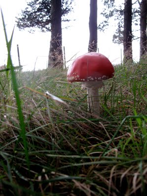
We see a perfectly formed red toadstool (fly agaric) which demands its own photograph then prepare to emerge into the open.
As always at  this point, and I do mean always, it has started to rain. I don't think we've ever been to Hope Cross on a perfectly clear day. So since I have to down the rucksack (yes, I'm still carrying it) to get out my waterproof coat I fetch out the Secret Flask too. The Ramblers' Restorative does just what it says on the Flask. A couple of nips each and we're raring to go - after we've clambered over the two stiles.
this point, and I do mean always, it has started to rain. I don't think we've ever been to Hope Cross on a perfectly clear day. So since I have to down the rucksack (yes, I'm still carrying it) to get out my waterproof coat I fetch out the Secret Flask too. The Ramblers' Restorative does just what it says on the Flask. A couple of nips each and we're raring to go - after we've clambered over the two stiles.Someone has left some yellow flowers on top of the cross which look very cheerful in the midst of the drizzle and low cloud. I go around the high wall to study the cross. It is dated 1737 with its four sides signed Shefield (yes, one f), Edale, Glossop and Hope. It is believed that this is a restoration or a replacement of an earlier cross.

The flat topped cross sits next to the ancient roman road which ran from Glossop to Brough and which is still, in places, a path. Here is one of the heavily used stretches and it has been said that, at certain times, roman soldiers can still be seen marching here. Never actually seen them ourselves, so we can't substantiate this!
We walk along the side of the path keeping between the high wall and the tree line to protect us from the rain. There are more walkers out on this side of the hill, though not a large number. Soon, though, the rain stops and we discover that we should have walked on the path this far, as we've come up against a no-stile. Basically, there are some fencing rails and a gap where the step should be. PC curses as she climbs over it, damning it as the worst stile in the Peak District, although she'll probably reallocate the title elsewhere in the future.
It's up and down underfoot next to the treeline, but we shun the well trodden path because we're a bit perverse like that. We do see a lot of fungi, though, ranging in colour from sickly cream to deep burgundy, and do benefit from shelter provided by the wall. Some of the sheep give us odd looks, but they're sporting purple splodges on their fleeces so they've no need to stare!
By the time we're in sight of our turn-off back down into the woods we're more than ready for our lunch, and fortunately there are enough tumbled sections of wall to provide somewhere comfortable to sit.
It's nice to get the rucksack off (yes, I'm still carrying the rucksack) and enjoy a cup of coffee. PC's made a good flask of coffee today (even though I've carried it all the way here) and as the first cup is downed the sky looks as though it might manage to clear. After the coffee we eat our sandwiches (yes, carried them too), have a second coffee, then fetch out the buns.
Mr Morrison has provided puff pastry fresh cream mince pies for us today. They're 'new', a welcome precursor to the Christmas season (unlike the infernal jingly songs blasted out in every shop and supermarket at this time of year which are only guaranteed to make goodwill to all men evaporate at super speed). The mince pies go down extremely well, and are washed down by the final dregs of coffee. At least when the rucksack is packed it is much lighter.
From here it's going to be pretty much all downhill. What a pity then that the path (a Footpath, not a Bridleway) has been churned into a slippery mess by mountain bikers. We pass two on our way down, but they don't seem even slightly ashamed that they are on a footpath and shouldn't be there.
The second part of the path through a young conifer plantation isn't nice to walk on; stony, rutted and churned in the centre, slippery at the edges. But when we can look up from where we're walking the views opening up across to Crook Hill are superb. The cloud has lifted and although the sun isn't shining at least it is clear.
We turn right on the broad track which contours the hill so remains fairly level, and since the trees to our left have been cleared we can see the patchwork woodland on the opposite side of the valley. Narrow lines of russet and pointed triangles cut through dark green blocks to make geometric shapes. We could make some interesting mathematical questions using the shapes - how many trees will you need to fill a space the size of...maybe not.
The path is a little soggy in places with one or two puddles, but we haven't walked too far when it suddenly changes and becomes a gouged hollow in the ground. Clearly diggers have been cutting a deep track though why the cut needs to be so severe is a mystery to us. From hereon we are walking below ground level on muddy (sometimes extremely muddy), stony ground. It isn't particularly pleasant as we have to watch where we're putting our feet as opposed to enjoying the view and when it starts to slope down we have to be doubly careful.
At one point, where a stream discharges on the track, we have to do a balancing act on a log to avoid being sucked into the mud. The potential for humour or disaster are great, but both are avoided. Eventually the path nose dives and takes us down to the broad path that skirts the reservoir. Now all we have to do is walk back.
We've made good time, but the clouds are gathering again and the light is fading. As we approach the path to the dam wall there's a biker repairing a puncture. Poor guy, hope he hasn't far to go afterwards or he may be caught out.
We're soon across the dam and back to the cars. I take off the rucksack and hand PC her flask (yes, I've carried it all the way and no, I won't let her forget it), but we don't have time to linger. Next week's walk is already planned so we're into our cars and away before the dusk swallows us up.
No comments:
Post a Comment