Stanage
Showing posts with label upper burbage bridge. Show all posts

Monday, 23 March 2015

BURBAGE TO STANAGE AND BACK

Well, it happened again. Cancelled walks - this time due to my mother falling and being hospitalised - and a long wait before we are able to get out again. Then PC succumbs to the recent bug/chest infection which means choosing something steady.

So we park up at Upper Burbage Bridge after passing coach-loads of school children - must be that time of year again when Geography teachers get to introduce their pupils to the Great Outdoors. It's actually quite chilly and murky this morning, although when I left home the sun was trying to shine. Fingers crossed the weather will improve.

Plenty of layers, then, as a guard against the cold, after which we need to restrain Mollie who is more than eager to go.

We cross the road and walk along the verge to the level path that is part of the Sheffield Country Walk. A woolly-legged grouse scuttles off in front of us as we do our usual catch-up talk. When we come to the rise up onto the first part of the edge we have to be careful due to the large stones and boulders that appear to be ready to be used for path repairs.


Once over these we climb up onto the start of the edge with the wide rocky slabs of gritstone and peaty puddles. We very quickly arrive at the trig point but the view, usually so good, is disappointing. A widespread murk covers everything in sight. PC gamely takes a few photos, though, before we set off along the edge.

This is oh-so-familiar, we have lost count of the number of times we have walked here, but it makes for steady - if uneven - walking which is ideal for PC. We are fairly early and the usual crowds have yet to arrive so we pretty much have the paths to ourselves.

We walk on for a while before deciding to sit on one of the rocky outcrops for a coffee and to admire the - well, the murk actually. Spiced vanilla latte again, which is lovely though a little on the thick side today. No idea why, maybe too much milk to water, but it goes down well.

As we continue we consider the best options. PC doesn't really feel up to a long haul uphill which would be the case if we drop off the edge (not literally!) and walk up the road, so we decide that after lunch we will turn back, descend a little way and hopefully not lose too much height.


Our lunch stop is familiar, yes, we even have our favourite eating places up here, where we can admire the view along the edge (not quite as murky now) and keep a little sheltered from the gentle breeze.

Sandwiches, coffee and pre-Easter hot cross buns, but this time with fresh cream and jam filling. Yum. Mollie devours her biscuits and drinks out of her new, collapsible water bowl.


Then it is back on with our gear and retracing our steps. Unsurprisingly there are now loads of people out walking so it is good when we find a descent a little south of Stanage Plantation  along what seems to be a stream bed, but is actually a path that just happens to drain water from the top.


Soon we are walking through the dry, rusty bracken beneath the Edge and can see the climbers scaling the cliffs. The path comes and goes, in places it is indistinct, but it is uninterrupted walking. At last we see an incline and decide to go up it to avoid PC having to slog up the road further on.


A few steps later and we are back on the top, with minimal effort, but after a short distance we once again choose to go down and find a way to skirt the uppermost point where the trig point is along with a lot of people. We're successful, and make our way through the bracken and around rocks to emerge on a broad path which takes us to some roadside parking.

We cross the road and walk along it until we can cut across and go through the gate at Fiddler's Elbow, which suits Mollie much more than road walking.


It isn't far now and in no time we are back at the cars. PC is in fine shape, the walk hasn't been strenuous and she hasn't had a relapse so it has all been worth while. Just a pity about the views.

Friday, 21 November 2014

A BURBAGE CIRCUIT

Winter is coming and the weather to match it; cold, windy, damp and murky. We have decided on an old familiar route today, one we haven't done for a while, but when we meet up at the Upper Burbage Bridge car park we are quite surprised to find very little company. This is usually extremely popular at all times of year so it is most unusual for there to be only two or three cars there.


We pull on plenty of layers this morning, the wind is distinctly chilly, the sky is very overcast and rain is a constant threat, so we add our water proofs on top to make sure we aren't caught out. Mollie is eager to walk, this is her first with us for a while.


Braving the road we cross over the bridge and onto the path choosing to go up onto the lesser used Burbage Moor track. There are plenty of puddles and boggy bits from the overnight rain, and we meet a few walkers too. The path down below Burbage rocks seems to be unused (it is usually the 'busy' path) and we soon discover why. Diggers, workmen and even a helicopter are down by Burbage Brook clearing the conifers and making 'improvements'. The path will be closed - in the week only - for quite some time.

We are untroubled for now by the closed path and continue on our way admiring the view and (no surprise here) talking. We decide not to stop to eat until we are on the far side of the brook, but that doesn't stop us pausing for a warming nip from the secret flask. Today PC attempts to guess the contents, without success. It is Sloe and Apple Vodka made with apples from the garden and some sloes left over from the gin making. It has turned out well, and I certainly prefer it to the Sloe Gin.

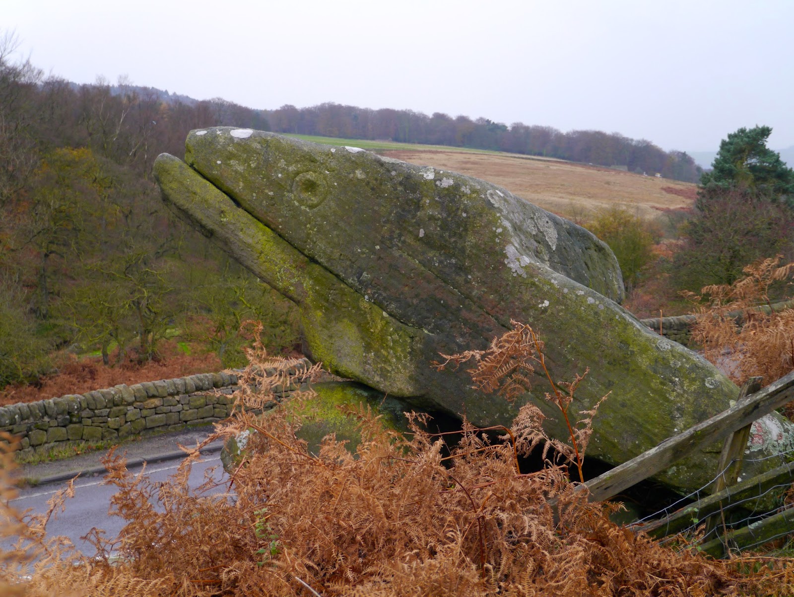
Suitably warmed we press on to the end of the trail, out of the gate and onto the road for a short stretch. We cross over the brook at Burbage Bridge and take the stile at the other side, clamber uphill at the side of Toad's Mouth then find ourselves a sheltering rock face where we can sit and eat lunch.

The rain is making more of an effort now so we don't linger too long. Spiced vanilla latte makes a change from ordinary coffee, then sandwiches, followed by lovely custard Danish pastries. The pastry is so light we feel as though we have hardly indulged, but we don't inspect the calorie count!


From here we continue up to the top of the small ridge then follow a path along Hathersage Moor, picking our way carefully and reflecting on how easy it would be to become lost. We walk up onto Carl Wark and admire the huge boulder-like stones on its northern side. Then it is a straight path to Higger Tor which, as usual, defies a straight and easy ascent as we make our own route and scramble through the rocks.


The view from the top, though, is superb. But the cold makes sure we don't linger. Although the top of the Tor is a mix of rocks and small tracks, once we reach the far side we are onto the straight path leading us back to the car park. There are few people out now, and the car park is deserted apart from our cars. Daylight on this murky day is waning fast, a sign that soon it will be dark by mid-afternoon. We are cold, and a little damp, but it has been another excellent walk.


Friday, 23 March 2012

A CIRCUIT OF BURBAGE AND HOUNDKIRK MOORS


Wow! We've done it again. The early fog has lifted and we have another fantastic day in prospect. This straight run of good weather is nothing short of miraculous, at the very least we expect a couple of walks leaving us soaking wet and squelching at this time of year (any time of year, to be honest) but we're not about to complain.


I'm late so PC is sat patiently in the car park at Upper Burbage Bridge waiting for me. Unfortunately she's forgotten the camera but has promised to take photos on her phone. Good job she's the techno one!


Despite the sunshine it is bitterly cold and at this high point (398m) we can really feel the wind. We both bemoan the fact that we'd been lulled into leaving one of our extra layers at home but with pull out hats, scarves and gloves as compensation. Mollie is clearly bored with waiting and is keen to be off, so much so that she's not too bothered by the traffic whizzing past.


We cross over Upper Burbage Bridge then turn through the gate onto the well-worn path which is part of the Sheffield Country Walk. However, instead of following the 'low road' we strike off to the left on the footpath which runs along the edge of Burbage Moor and Burbage Rocks.
It's a familiar route to us with its wonderful far-reaching views, but it is not as well used at the lower path, possibly due to the rougher terrain and the longer length. However, we enjoy being away from the crowds, and there are plenty of people about today.


We keep pausing to look over to Higger Tor and Carl Wark, and we can clearly see the spot where The Wood That Wasn't, isn't! (Must, must, must write about this at some point.)


The path descends to an unnamed stream, and Mollie pauses to have a drink before we hop over. It can be a little boggy around here, but today it isn't too bad and we're able to keep dry footed and mud free. Then it's up the slope at the other side and crossing the long path which runs from Hathersage to Whitelow at the other side of the Peak Park boundary. Once at the top of the slope we're amongst the rocks and find ourselves a suitable place to stop for a nip from PCs secret flask. Mine, alas, is empty as I forgot to refill it after last week, but PC has saved the day with her flask of Cointreau. It takes a bit of effort to unscrew the top, but the promised reward ensures our success and we're soon savouring the flavour of the Mediterranean whilst gazing over the Derbyshire Moors!


The breeze is still brisk so we pack up and move on. The path on this part of the walk is narrower with higher rock formations on the western side providing some shelter from the wind. Since the path is heading gently downhill we catch our first glimpse of Fox House in the distance and after a quick consultation we decide that we'd better stop for lunch here as there doesn't seem to be many promising spots further on.


We find ourselves an excellent seat and 'round table' amongst the brittle, brown bracken. A huge millstone, seemingly complete, lays abandoned and forgotten so we spread out on it for lunch. The usual sandwiches, heavy salad and coffee (biscuits and water for Mollie) are followed by fresh cream strawberry tarts - our bun of the day. The pastry is lovely and crisp, but it does make eating a little messy and Mollie is on the lookout for crumbs. We linger over coffee (longer than we should) then have to drag ourselves upwards and onwards.


The path leads us past a large, incomplete water trough - the outside perfectly shaped but the inside only partly hollowed - then down towards a gate onto the A6187. Mollie isn't so happy now that we've come to the road so we cross over and take the path through the top part of the Longshaw Estate to avoid the traffic. Even though the trees are yet to come into leaf it still feels like spring here and it is a lovely place to walk, although at weekends it is probably heaving with activity. The path leads us out onto the Grindleford Road (B6521) which we cross to skirt through the top edge of Longshaw to reach Fox House.


It's pretty grim trying to cross the road here, and the cars tend to hurtle past at a fair pace despite the blind bend, but we make it across then trudge up the A6187, cursing the parked cars which force us to walk on the road, until we reach the left hand unmade road (Byway open to all traffic) which is Houndkirk Road. Here we're able to walk danger-free again, unless we're assaulted by 4x4s.


Houndkirk Road seems to be a turnpike road built sometime in the 1750s, although I have seen a reference that it may, in fact be a Roman road. However, it's hard to find any detailed information on the internet due to the high number of forums etc devoted to the recent resurfacing/improvements to the road and the opinions of the wheeled community.


When we walk along the road, lovely and quiet today, we can see the evidence of the 'improvements' which includes the placing of large boulders to prevent motorised vehicles widening the road or driving on the moor. It is clear that the road has suffered greatly from heavy use and erosion making it a long winding scar across the landscape.


We're finding it quite pleasant, the wind has dropped (or maybe we've dropped out of the wind), and Mollie has plenty of stones to keep her amused. The landscape is pretty bleak and featureless but soon we see the distinctive mound of Houndkirk Hill which shields us from the sight of Sheffield's suburbs. The road seems to go on forever, but since it is reasonably evenly surfaced we make good time.


Eventually we turn left on another track which crosses Houndkirk (this is, I believe, Jumble Road) and we meet a man walking his huge 11 month old Great Dane. What an impressive dog! Very strong too, and it's owner has to keep a tight hold on this 'youngster'.


A little distance and we reach the edge of Lady Canning's Plantation, an extensive conifer wood filling the space between this track and Ringinglow. Although conifer woods are not the most attractive of places the lovely fresh pine scent (real, not manufactured!) fills the air.


We plan to walk the length of the lane, but are sidetracked (literally) by a narrow but distinct path through the heather. It isn't marked on the map but we decide to give it a go. It is running roughly in the right direction and if it turns out to be a blind alley we can always turn around.


As we walk forward we see a trig point (419m) and the huge wind sculptured stones known as the Ox Stones. These are definitely worth the detour as we wouldn't have known they were here if we hadn't made the effort. After a look around we decide not to follow the very muddy but vague path westwards (we aren't sure it actually goes anywhere useful) but follow a very clear path which takes us back towards our original destination, depositing us very nicely at the end of Jumble Road where it joins Ringinglow Road.


Now for the worst bit. We have to walk along the road back to the car park, but as it turns out it isn't that bad - although it seems less of a distance on the map than on the ground! The sun is dipping in the sky by the time we make it back to Upper Burbage Bridge and we've run out of time. We probably dawdled a bit too much on the outward stretch of the walk, then had to push the pace on the return, but we've thoroughly enjoyed it. Next week's walk will be a surprise - we haven't had time to plan it yet!




Monday, 27 September 2010

STANAGE EDGE - END TO END


We'd had this one on our minds for a while. Stanage Edge is one of our favourite walks but we have never completed the full length, always dropping down and doing a circular route at the half way point or just beyond. The time was right for us to do the end to end walk, so we'd plotted and planned (it involved a car at each end and driving between start and finish) and after the initial ferrying about we were keen to get started.


We set off from the Upper Burbage Bridge car park, our eyes fixed east. The first bit is easy, a short stretch of level moorland track then a short haul up onto the ridge.
Even this small ascent gives wonderful views in all directions, but we press on across the slabbed path through the heather and rocks to the trig point. We always pause here but today the sky isn't really clear enough for a good photograph. However, we do get a sense of how far we'll be walking, although we can't see the end of the 3.5 mile ridge from here.
This is easy, familiar walking, and strangely quiet. Even on cold weekdays there are usually hikers and climbers up here, but we see no one. Maybe the grim weather forecast has put people off but although the wind is bitterly cold the distant clouds don't appear to be too threatening.
As we walk along the ridge we have clear views and can see that the trees are starting to take on their autumn colours. Some, such as the horse chestnuts, are already wonderfully golden but some are just turning to a crispy, muddy brown.
Fluffy legged grouse let out their peculiar cry - or is it a strangled squawk? - and run away from us only to stop and peer over the heather. They're safe, for now. We're not gun-toting 'sportsmen' and can't see the sense in killing for fun.
We ignore the heavily eroded track down to the left - Long Causeway, formerly a roman road from Doncaster - which is our usual descent and keep on the ridge. The path narrows briefly and a short step of rock has to be negotiated, easy-peasy for our nimble figures, then we're up and over the stile onto the second half of the walk.
The path on the OS map actually runs beneath the ridge, and is clear to see, but most people walk on top of the edge to enjoy the views, as we do.
The trig point at High Neb marks the highest part of the edge at 458 m but before we reach it PC trips up and the secret flask has to be brought out for medicinal purposes. She deems it to be a miracle cure, so we stop for lunch hunched up with our backs to the wind and the view. Our coffee (and the secret flask) are welcome accompaniments to the lemon and poppy seed muffins. They look odd sprinkled with black specks, but taste good with a proper lemony curd filling devoid of any fluorescent colourings. They are surprisingly filling, but that could have been because of our heavy salads.
As we set off from our picnic spot we see the first pair of walkers of the day going in the opposite direction, and we're the first they have seen. We all remark on how unusual it is, but how much better not to be milling around with the crowds. Then we part company and are off again.

From here the view is new to us, so we stop briefly at the trig point to look around then keep going to the edge to see what we can see. Much the same as before, actually, but from a different perspective which makes it interesting. We can also see the long S-shaped curve of the whole edge from this point and it is probably the only place from up here where you can just about see the whole length.

As we continue on the path we keep spying out old walks such as along Bamford Edge and Win Hill,and use the opportunity to check out other useful paths for the future. In general though, we're both agreed that this half of the edge doesn't quite match up to the other half, although it is probably less popular which has its own appeal.In places the path becomes quite wet and even boggy, it will probably be a quagmire when there has been a reasonably amount of rain. Stanage End is soon upon us and we descend a few feet to the 'proper' path. There are lots of gritstone walls here, high as though for enclosures or buildings, but without any proper form that we can see. Without exploring them we head on the gentle decline on the path through the tussoky grass towards the A57.
The sun has come out now and it's quite warm and very pleasant, far different from when we set off this morning. We pause to look back at the edge, but the view from here is unimpressive. It gives little a indication of height but no clues as to length. We agree that we have definitely walked in the best direction.
The walk down the road isn't pleasant with the fast moving traffic zooming past, but we reach the lay-by safely and are soon in the car on the way back to Upper Burbage Bridge. There we pause to plan our next outing, but looking back where we've been today we see ominous black clouds approaching quickly.

Going our separate ways I can see over to Castleton, and it is completely hidden beneath a thick grey fog of torrential rain. We've been lucky to have missed the rain, it made a good walk even better.