Stanage
Showing posts with label Carl Wark. Show all posts

Wednesday, 3 February 2016

HATHERSAGE MOOR


Due in part to our lack of exploration last week, and also the prospect of a dodgy pay and display machine giving us cheap parking, we once again meet up in the Surprise View car park with a vague plan of action  to enjoy a more scenic route today.

We're still in luck, the parking machine will still only let us pay for one hour (card payments only!) which we duly do before preparing to set off. There are still remnants of snow and a heavy frost tucked into the tussocks of grass and shady side of rocks. The wind is a chill one too, but at least the sun is shining today - and it has brought out a fair few walkers too.


We head off on the path that rises up through the sparse woods at the back of the car park and climb carefully up the rocks. Fortunately millstone grit isn't slippery, unlike the White Peak's limestone.

Mollie finds a toy to play with and we head onwards on the path towards Mother Cap. We detour off to the right as a chatty family group start to catch up with us. They aren't well dressed for walking so we guess they won't be going too far, we move away to let them overtake us as we explore the stones on the right of the moor before winding back to the path.


Mother Cap is a very distinctive - and much climbed - natural monument of stone, visible for miles.


We walk around it and continue along the path heading towards Windyards Nick. Now we are on the same route as last week, only with a better view.

We can see for miles, and we have a brief debate on whether the birch wood (pictured) could, in certain atmospheric conditions, seem to appear near the enclosure/sheepfold on Hathersage Moor, which is still some way off. PC says Yes. I say No.

We reach the aforementioned sheepfold and take the route around its southern edge and head towards Higger Tor.

It's always a bit of a huff and puff climbing up here, but the views towards Carl Wark are worth it.
It is quite busy on the top of the Tor, and a bit too chilly too. We start to make our way down on the other side as PC declares that we need to head into the coniferous woodland through which Burbage Brook runs. It is, she says, a non-negotiable stopping place (for obvious reasons).

Fortunately we find a comfortable spot in the woods where we are out of the wind and out of sight (more or less) and although it would be nice to say it was peaceful the constant yelling and screaming of a school-group up on the Tor carries for miles. 


However, it is good spot for lunch and coffee, and the much anticipated buns (cinnamon swirls - more cinnamon next time, please).

With lunch over we have a brief debate as to where to head next and choose, to go down to the brook and cross over. This turns out to be one of our less successful ideas. Whereas there is a visible path on the other side reaching it is probably only possible for those possessing greater agility than ourselves.

To begin with we have to negotiate the lumber left over from the felling of swathes of the wood (either last year or the year before) then find that the brook is flowing fast and deep. Any stones that might prove useful for crossing are either submerged or covered in slippery moss. We decide, instead, to follow a sort-of path at the side of the brook - we clearly aren't the only ones who have trod this way.

It is a bit up and down, and a bit uncertain in places, but we never actually find a place to cross. And again we end up having to scramble over heaps of discarded branches. We end up letting Mollie off the lead to make her own way, there aren't any sheep about and she is much better left to her own devices.


Eventually, though we come in sight of the little footbridge that takes the main path off of Carl Wark. It is quite muddy in places as a young couple, not ideally dressed for a day out, discover when she slips down. Unharmed, though, they continue up towards Carl Wark as we cross the bridge.


A new bridge has been built here recently, looking quite stark against the muted hillside. 

We walk up to the  main path running under Burbage Rocks and aren't at all surprised that there are so many people walking here. It is an easy route, and we make good time to the end of the road and the path. 

Once over the road we go through a gate into the edge of the Longshaw Estate, turn right to follow the road then through another gateway and across a stone clapper-type bridge.


We follow the familiar route down and skirt the lower reaches of Burbage Brook, following it until we turn right on the high-banked path leading us back to the car park.

We have made pretty good time, and made so much more of the walk than last week. Fingers crossed we'll do as well next week.

Friday, 21 November 2014

A BURBAGE CIRCUIT

Winter is coming and the weather to match it; cold, windy, damp and murky. We have decided on an old familiar route today, one we haven't done for a while, but when we meet up at the Upper Burbage Bridge car park we are quite surprised to find very little company. This is usually extremely popular at all times of year so it is most unusual for there to be only two or three cars there.


We pull on plenty of layers this morning, the wind is distinctly chilly, the sky is very overcast and rain is a constant threat, so we add our water proofs on top to make sure we aren't caught out. Mollie is eager to walk, this is her first with us for a while.


Braving the road we cross over the bridge and onto the path choosing to go up onto the lesser used Burbage Moor track. There are plenty of puddles and boggy bits from the overnight rain, and we meet a few walkers too. The path down below Burbage rocks seems to be unused (it is usually the 'busy' path) and we soon discover why. Diggers, workmen and even a helicopter are down by Burbage Brook clearing the conifers and making 'improvements'. The path will be closed - in the week only - for quite some time.

We are untroubled for now by the closed path and continue on our way admiring the view and (no surprise here) talking. We decide not to stop to eat until we are on the far side of the brook, but that doesn't stop us pausing for a warming nip from the secret flask. Today PC attempts to guess the contents, without success. It is Sloe and Apple Vodka made with apples from the garden and some sloes left over from the gin making. It has turned out well, and I certainly prefer it to the Sloe Gin.

Suitably warmed we press on to the end of the trail, out of the gate and onto the road for a short stretch. We cross over the brook at Burbage Bridge and take the stile at the other side, clamber uphill at the side of Toad's Mouth then find ourselves a sheltering rock face where we can sit and eat lunch.

The rain is making more of an effort now so we don't linger too long. Spiced vanilla latte makes a change from ordinary coffee, then sandwiches, followed by lovely custard Danish pastries. The pastry is so light we feel as though we have hardly indulged, but we don't inspect the calorie count!


From here we continue up to the top of the small ridge then follow a path along Hathersage Moor, picking our way carefully and reflecting on how easy it would be to become lost. We walk up onto Carl Wark and admire the huge boulder-like stones on its northern side. Then it is a straight path to Higger Tor which, as usual, defies a straight and easy ascent as we make our own route and scramble through the rocks.


The view from the top, though, is superb. But the cold makes sure we don't linger. Although the top of the Tor is a mix of rocks and small tracks, once we reach the far side we are onto the straight path leading us back to the car park. There are few people out now, and the car park is deserted apart from our cars. Daylight on this murky day is waning fast, a sign that soon it will be dark by mid-afternoon. We are cold, and a little damp, but it has been another excellent walk.


Monday, 4 March 2013

A LONGSHAW LOOP


It feels like forever and a day since we were last out walking, we've had illness, injury and half term to contend with, but we're out again with something simple just to get us back into the swing of things without pushing our depleted fitness levels too far. And the sun is shining!

We park up at the popular spot at the side of the road from Grindleford, close to Granby Barn, and as soon as we're togged up it's photograph time. We have a wide sweep here to choose from, with wonderfully clear views of Higger Tor and Carl Wark. Photos finished we walk a short way along the road and take the path down towards Burbage Brook. Despite the glorious sunshine it is very cold and there is ice on the stream edges and coating exposed boulders. There is even some snow lingering in sheltered, sunless spots.

There are a lot of people out today, and we have delayed a little to avoid a large, strung out walking group. For some reason groups seem to be cropping up everywhere we go - we barely missed being drafted into one at Baslow a few weeks ago.


With the last stragglers of the group out of sight we go down to the Brook, pause again for some photographs then follow its banks upstream. We're ambling along at a very leisurely pace. Not having walked for some time we do have a lot of catching up to do so we need to conserve our breath!


We cross the water again and start climbing up the surfaced path towards the Longshaw Estate, go through the gate then walk along the wide track through the trees. The sunlight makes the tree trunks and boulders cast long shadows, and there are a lot of gritstone boulders wedged into the hillside here. (PC has a particular fondness for boulders!)


At the end of the path we go through the narrow gate, cross the road and head up the driveway towards Longshaw. There are certainly a lot more people here, but the cafe is open (as are the toilets) which undoubtedly provides an attraction.


Most people are walking on the paths in front of the big house, but we head behind the Visitor centre and cafe complex onto the quieter path. PC can't resist nosing over the wall to look into the large kitchen garden, so Mollie and I wait patiently as she satisfies her curiosity.


Further along we pass through a large gate and come out on a broad, grassy track leading towards the aptly named Wooden Pole. There is also a very inviting bench, and our secret flask and a bar of chocolate beckon! We sit very comfortably enjoying the distant views and listening to the sound of tinkling bells. Turning around we see a tree festooned with wind chimes. The tree is fenced in, but I can't find any details as to why the tree has been decorated.


Leaving the tree behind us we stroll along the path towards Wooden Pole, then detour slightly down to the car park and onto the path next to the entrance. Then we're on a clear track going through the sparse woodland of the estate leading down to rough moorland.


We're on the lookout for somewhere to sit for lunch, and soon we find it by crossing the dead, buff-coloured grass to park ourselves on a suitably sized flat boulder. We're comfortable, sat in the sunshine and still have a good view.


Out come sandwiches and coffee for us, biscuits and water for Mollie. Then we have our buns, fresh cream eclairs which, as noted on a previous post, are the perfect shape for walking buns.

We know we don't have a long way to go now so we don't rush, but it is a bit chilly sitting around so we pack up our things and amble on. It's extremely easy walking, probably why this area is such a magnet for families out for a stroll, and as we walk we notice signs to entice youngsters: the ant walk, the boggart hole.


Eventually we come to another gateway and at the far side of it we reach a path which gives us two options, either up towards the Visitor centre or down towards Granby Barn. We take the left hand route towards the barn, and from there the road and our cars.

The sun is still out when we get back to the cars so we have time to sit and reflect, and chat some more. We know how lucky we have been to have been out on such a bright, clear day and we can only keep our fingers crossed that our next walk will be just as good.

Friday, 23 March 2012

A CIRCUIT OF BURBAGE AND HOUNDKIRK MOORS


Wow! We've done it again. The early fog has lifted and we have another fantastic day in prospect. This straight run of good weather is nothing short of miraculous, at the very least we expect a couple of walks leaving us soaking wet and squelching at this time of year (any time of year, to be honest) but we're not about to complain.


I'm late so PC is sat patiently in the car park at Upper Burbage Bridge waiting for me. Unfortunately she's forgotten the camera but has promised to take photos on her phone. Good job she's the techno one!


Despite the sunshine it is bitterly cold and at this high point (398m) we can really feel the wind. We both bemoan the fact that we'd been lulled into leaving one of our extra layers at home but with pull out hats, scarves and gloves as compensation. Mollie is clearly bored with waiting and is keen to be off, so much so that she's not too bothered by the traffic whizzing past.


We cross over Upper Burbage Bridge then turn through the gate onto the well-worn path which is part of the Sheffield Country Walk. However, instead of following the 'low road' we strike off to the left on the footpath which runs along the edge of Burbage Moor and Burbage Rocks.
It's a familiar route to us with its wonderful far-reaching views, but it is not as well used at the lower path, possibly due to the rougher terrain and the longer length. However, we enjoy being away from the crowds, and there are plenty of people about today.


We keep pausing to look over to Higger Tor and Carl Wark, and we can clearly see the spot where The Wood That Wasn't, isn't! (Must, must, must write about this at some point.)


The path descends to an unnamed stream, and Mollie pauses to have a drink before we hop over. It can be a little boggy around here, but today it isn't too bad and we're able to keep dry footed and mud free. Then it's up the slope at the other side and crossing the long path which runs from Hathersage to Whitelow at the other side of the Peak Park boundary. Once at the top of the slope we're amongst the rocks and find ourselves a suitable place to stop for a nip from PCs secret flask. Mine, alas, is empty as I forgot to refill it after last week, but PC has saved the day with her flask of Cointreau. It takes a bit of effort to unscrew the top, but the promised reward ensures our success and we're soon savouring the flavour of the Mediterranean whilst gazing over the Derbyshire Moors!


The breeze is still brisk so we pack up and move on. The path on this part of the walk is narrower with higher rock formations on the western side providing some shelter from the wind. Since the path is heading gently downhill we catch our first glimpse of Fox House in the distance and after a quick consultation we decide that we'd better stop for lunch here as there doesn't seem to be many promising spots further on.


We find ourselves an excellent seat and 'round table' amongst the brittle, brown bracken. A huge millstone, seemingly complete, lays abandoned and forgotten so we spread out on it for lunch. The usual sandwiches, heavy salad and coffee (biscuits and water for Mollie) are followed by fresh cream strawberry tarts - our bun of the day. The pastry is lovely and crisp, but it does make eating a little messy and Mollie is on the lookout for crumbs. We linger over coffee (longer than we should) then have to drag ourselves upwards and onwards.


The path leads us past a large, incomplete water trough - the outside perfectly shaped but the inside only partly hollowed - then down towards a gate onto the A6187. Mollie isn't so happy now that we've come to the road so we cross over and take the path through the top part of the Longshaw Estate to avoid the traffic. Even though the trees are yet to come into leaf it still feels like spring here and it is a lovely place to walk, although at weekends it is probably heaving with activity. The path leads us out onto the Grindleford Road (B6521) which we cross to skirt through the top edge of Longshaw to reach Fox House.


It's pretty grim trying to cross the road here, and the cars tend to hurtle past at a fair pace despite the blind bend, but we make it across then trudge up the A6187, cursing the parked cars which force us to walk on the road, until we reach the left hand unmade road (Byway open to all traffic) which is Houndkirk Road. Here we're able to walk danger-free again, unless we're assaulted by 4x4s.


Houndkirk Road seems to be a turnpike road built sometime in the 1750s, although I have seen a reference that it may, in fact be a Roman road. However, it's hard to find any detailed information on the internet due to the high number of forums etc devoted to the recent resurfacing/improvements to the road and the opinions of the wheeled community.


When we walk along the road, lovely and quiet today, we can see the evidence of the 'improvements' which includes the placing of large boulders to prevent motorised vehicles widening the road or driving on the moor. It is clear that the road has suffered greatly from heavy use and erosion making it a long winding scar across the landscape.


We're finding it quite pleasant, the wind has dropped (or maybe we've dropped out of the wind), and Mollie has plenty of stones to keep her amused. The landscape is pretty bleak and featureless but soon we see the distinctive mound of Houndkirk Hill which shields us from the sight of Sheffield's suburbs. The road seems to go on forever, but since it is reasonably evenly surfaced we make good time.


Eventually we turn left on another track which crosses Houndkirk (this is, I believe, Jumble Road) and we meet a man walking his huge 11 month old Great Dane. What an impressive dog! Very strong too, and it's owner has to keep a tight hold on this 'youngster'.


A little distance and we reach the edge of Lady Canning's Plantation, an extensive conifer wood filling the space between this track and Ringinglow. Although conifer woods are not the most attractive of places the lovely fresh pine scent (real, not manufactured!) fills the air.


We plan to walk the length of the lane, but are sidetracked (literally) by a narrow but distinct path through the heather. It isn't marked on the map but we decide to give it a go. It is running roughly in the right direction and if it turns out to be a blind alley we can always turn around.


As we walk forward we see a trig point (419m) and the huge wind sculptured stones known as the Ox Stones. These are definitely worth the detour as we wouldn't have known they were here if we hadn't made the effort. After a look around we decide not to follow the very muddy but vague path westwards (we aren't sure it actually goes anywhere useful) but follow a very clear path which takes us back towards our original destination, depositing us very nicely at the end of Jumble Road where it joins Ringinglow Road.


Now for the worst bit. We have to walk along the road back to the car park, but as it turns out it isn't that bad - although it seems less of a distance on the map than on the ground! The sun is dipping in the sky by the time we make it back to Upper Burbage Bridge and we've run out of time. We probably dawdled a bit too much on the outward stretch of the walk, then had to push the pace on the return, but we've thoroughly enjoyed it. Next week's walk will be a surprise - we haven't had time to plan it yet!


Monday, 28 March 2011

FAMILIAR BUT NO LESS FANTASTIC


Glorious. There's no other way of describing the weather forecast for today and our glee at hearing it: clear skies and sunshine. And it's only the middle of March. Yippee.

We meet up at Burbage Bridge. We know it's going to be a pretty straight forward walk and with the promise of superb weather we're not surprised to find plenty of cars in the car park. We can't blame people for doing the same as us. We make a quick decision as to which way around we'll be walking, then set off leaving the hoards behind us.

We set off on the western side of Burbage Brook heading towards Higger Tor - one of our many favourite places - and cross the rocky patch of, what is called on the map, Fiddler's Elbow. I think this refers to the rocks as well as the stretch of nearby road, but even so, there's not a fiddler in sight. Nor are there any other folk about. They've dispersed and gone their own ways - brilliant.

There are a few rocks to scramble down then an easy to follow path leading towards the Tor. It's not unusual for parts of this path to be soggy but we haven't had any rain in a while and today it's bone dry underfoot.

With the sun shining we're warming up, even though we're hardly pushing the pace, so by the time we reach the steps up to the summit of the Tor we need to pause to admire the views - which are spectacular (if we ignore the ever present eyesore of the cement works) - and to strip off a layer. A man hikes past us and comments that he has to keep reminding himself that it's only March. We agree. The sun is bright and the air smells warm and rich, more like June than March. Quite a contrast to our last walk 2 weeks ago when we were faced with a howling gale!

With a spring in our step we pull uphill to the flatish, rocky top of Higger Tor and decide to park ourselves in a convenient place to enjoy the view in comfort. Out comes the secret flask - cointreau today. Mmm, tastes of southern orange groves and with the sun on our faces it's easy to imagine ourselves transported to the Mediterranean. But really, on a perfect walking day like today, who needs the Med? This has to be one of the best places to be.

As we're contemplating the horizon the compulsory school group complete with red hard hats shatter the peace so we pack up and set off again.

From the top of Higger Tor the views are extensive, and by habit, we look for the wood that isn't there. Nope. Still not there. (Make a mental note that I MUST write about it on the blog.)

By this time we're down to shirt sleeves, quite an achievement at any time of year for me so it's a sign of how mild the weather is. We make our descent down the rugged side of the Tor utilizing all necessary body parts to facilitate a safe landing (ie feet, hands, bums) only to discover that a few yards to our left is the 'easy' route down. Oh well, intrepid adventurers like us don't need to use the easy routes.

The path is clear across to Carl Wark and as we approach its massive boulder-built walls we marvel anew at the remarkable feat of engineering undertaken to construct the impressive fortifications.


We exit the rough plateau of Carl Wark via the 'south gate' and head for a crossing over Burbage Brook. The path disintegrates to a number of tracks, none of which are particularly promising. It's usually a quagmire here and today it is still boggy so we have to pick our way carefully so as not to get sodden. At least it hasn't been raining.

Once we reach the brook we have the usual task of getting across. At least the flow of water isn't too bad, but it's a real boggy mess on this side of the stream. I trudge downstream to find an easier spot for PC to cross, but it doesn't really get any better. When I turn back to tell her that we'll have to go upstream, I find that she's already at the other side looking smug. Typical.

I cross using a couple of stones and a brief paddle, then it's sharply up the far bank and across the sheep grazed grass to the path. Here we decide that we'd rather walk along the top of Burbage Rocks than on the lower, busier path, so again we head uphill through the maze of gritstone boulders and heather until we reach the narrow track that runs the length of Burbage Rocks.

We find a place to sit where the sun warms us and we can enjoy the panoramic views up the Burbage valley and across to Carl Wark and Higger Tor. The landscape seems almost prehistoric and a few grazing dinosaurs wouldn't seem too out of place. Naturally, sandwiches, coffee and buns bring us back to the present. And the buns today are magnificent; wonderful, summer-scented strawberry tarts (sweet pastry, creme anglaise, strawberries, fresh cream). They turn an excellent day into a perfect one.

It's hard to summon enough willpower to get moving again but eventually we manage it. The path wanders through the rocks, dips past the bisecting path running from Hathersage Moor to Houndkirk Moor, and onward through the peat (thankfully dry) to the top of Burbage Rocks. The terrain is less dramatic here, but the views back along the ridge are wonderful.

We drag ourselves along. Not because we're tired, but because we don't really want the day to end. We pause again overlooking the brook from a height, and as we sit we plan our next walk, extending for as long as possible our time out on this glorious day.

But duty calls and we're tugged back to reality and the car park. It feels as though spring is in the air and we hope it keeps up for our next outing. although really, it doesn't get much better than this.

Monday, 13 September 2010

HATHERSAGE MOOR, HIGGER TOR, BURBAGE


Here we are for our first walk back after the summer holidays and it feels good to be out. We meet at the Surprise View car park under an unpromising sky of mist which threatens rain, not that it matters to hardy souls like us. We have loads of news to catch up with and are desperate to escape the accumulated post-holiday chores which have multiplied alarmingly in our absence.


We cope admirably with the parking-ticket machine which had us stumped on our last visit then set off gingerly, nursing a dodgy hip and back back - one each so they're equally shared.


The first stile is approached with caution but we cope with it easily. See, things aren't too bad after all! We almost immediately encounter a small uphill scramble, but experience of this means we know the easy way and we're soon on the open moor covered with a dense carpet of heather and spindly silver birch trees. The path is sandy underfoot due to the constant erosion of the sombre grey gritstone.


We're heading uphill here, but at a gentle gradient which gives us plenty of breath to talk about all that has happened since we last met up.


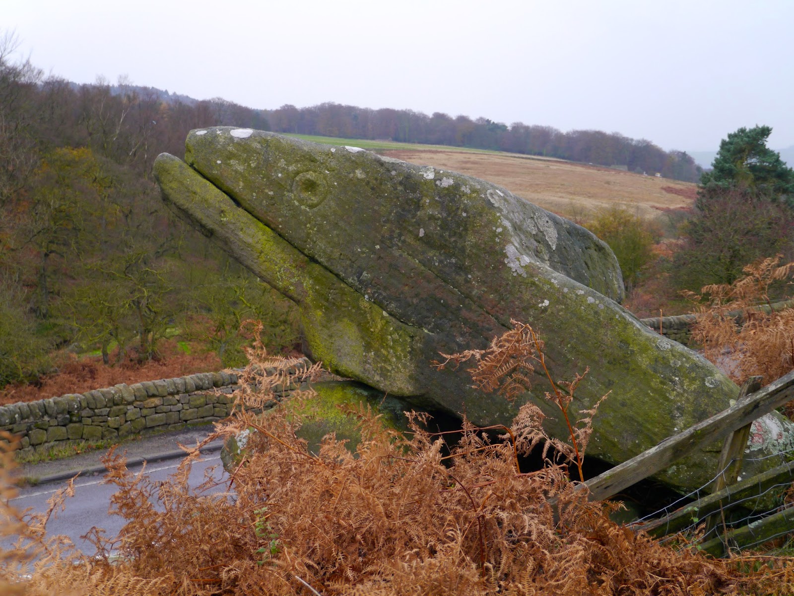
We pause to take photos of some of a couple of strangely eroded rocks that look like a pair of Komodo Dragons turned to stone, one looking north, the other south.

A short distance along we reach the towering bulk of Mother Cap, a large wind-weathered monolith that is visible from a great distance away. It is a popular site for climbers with a route up it being called, apparently, Conan the Librarian! Why? No idea.


After only a brief pause to admire the view, and to remove a layer of clothing - the sun has emerged - we head north towards the distinctive flat-topped rise of Higger Tor. We take a path that is not on the OS but is well used enough to be clear on the ground. Carl Wark, the iron age (or possibly even bronze age) hill fort is over to our right. Carl Wark isn't the only evidence of settlement here on Hathersage Moor although the fort is the clearest with the rest being buried beneath vegetation.

Our path dips at Winyards Nick with another crossing it, but we continue straight on. Soon we reach the only enclosure on the moor, a large rectangular sheepfold. As always we look for the 'missing wood'.


I'll explain. On a walk here some years ago, in snow and thick fog, we passed the corner of the sheepfold heading in the opposite direction and saw, heading roughly easterly, two cart tracks leading in to a wood of spindly silver birches. After much debate we decided to press on instead of going into the wood and forgot all about it. Until I went on a walk there some time later and - no wood! I asked PC. She remembered the wood too (I hadn't imagined it) so we went back together. Despite us both recalling the wood's exactly location and what it looked like, it quite simply wasn't there. A mirage? or some kind of window to a former time? We're still debating the point, and we look for the wood on every visit. One day we'll return in fog, just to see...


Skirting the enclosure boundary we head towards Higger Tor, which looms larger on our approach. We shun the direct ascent and skirt around to the east where we can climb up without undue effort. At the top we pause for a sip from the secret flask, but to our overwhelming frustration the top won't come off. We both try, even resorting to bashing the flask on a rock, but all we manage to do is form a hairline crack in the metal that oozes the odd drop of nectar. Grr.


Refusing to be daunted we set off on the clear path towards Upper Burbage Bridge. This whole area of the moor is very close to road so is easily accessible which makes for more visitors. There are quite a few small groups out, and we have to remind ourselves that although this area is on our doorsteps, it is actually a holiday location for many people.


We cross Burbage Brook by the bridge rather than the up and down scramble over the water. Our way is quicker, and safer, especially in our fragile states.


At the far side of the Brook we debate whether to take the high route on the top of Burbage Rocks on the edge of Burbage Moor or keep to the lower, easier path that forms, apparently, part of the Sheffield Country Walk. We opt for the easy route today but first drop down towards the Brook to sit on some boulders in the sun to eat lunch. The coffee is welcome, as is secret flask number 2 which is only brought out in times of dire need. It feels very civilised sitting here, sipping our drinks, eating lunch and contemplating the moors, the weather, life and everything. And buns. PC has done us proud. Two cup cakes - one lemon, one coffee - are duly presented for admiration before being ceremoniously cut in half and savoured.


It would be far too easy to sit here all day with life buzzing past inconsequentially, but we have to move so we hoist ourselves stiffly upright and head off.

We discuss which path to take, either the one on the top of the rocks, or the lower track. We go for the low track as it is track is so easy to walk and as such is far more popular than the paths on the other side of the Brook. Even today, midweek, we see more people than we usually do, and at weekends it will be like the M1. To our left the rocky ridge of Burbage Rocks stands starkly sculptured in the sun.We pause frequently to admire the views up and down Burbage Basin and across to Carl Wark.

When we reach the road we cross over and into the Longshaw Estate which gives us easy access back to the car park. We go over Burbage Brook by a footbridge then follow the stream side path to the footpath leading to Surprise View car park. When we arrive there we are surprised to see an ice cream van. Tempting, but no. Smugly satisfied that we can resist temptation we plan our next walk then head home with the sun still shining. An excellent first outing.