Stanage
Showing posts with label Wheel Stones. Show all posts

Tuesday, 23 February 2016

CUTTHROAT BRIDGE AND PAST THE GROUSE BUTTS


Again we opt for a familiar parking spot which is quite busy, although it is the school holidays and looking like it is going to be a good day.

With the sun shining we set off down the main road; a bit of a trial with only a narrow path at the side of the A57 to keep us out of the path of the hurtling traffic, but we soon make it to the crossing place at Cutthroat Bridge.

We go through the gate at the side of the bridge and the first thing we notice is the amount of rubbish dumped next to Ladybower Brook. Plastic boxes, bags, all sorts. Some people don't deserve to come into the countryside.

We go up the rocky path then drop down to the so-called ford over the fast flowing water of Highshaw Clough. Mollie leaps back and forth a few times before we find some stones to cross over dry-shod, then we climb up the short slope and onto the path that runs parallel with the main road.


There is an old waymarker stone on this path (mentioned on a previous post), just after the rather high ladder stile, that indicates that this was once the main route from Sheffield.
Now there are just fields and sheep, and a few walkers like ourselves and the couple behind us with their two dogs. The sheep are not impressed.
Before the path meets Moscar House we turn left (fortunately through the gate, the stone stile looks a bit too intimidating) and start the long but fairly gentle climb up onto the moor and the access land.

There are wonderful far-reaching views here, and we are making such good time that we decide to find a boulder and stop for a coffee. And a nip from the secret flask. Today's treat: vanilla vodka.

We debate staying around for lunch, we are in a lovely spot with the sun shining down on us, but we decide to move on and lunch later.
It's a steady walk up the hill and there are quite a few people about though, fortunately, not too many. There are grouse aplenty though, clearly the shooters haven't had them all. The grouse butts are fenced off which is a shame, in poor weather they do provide a handy refuge for walkers.

We reach the top south of the Wheel Stones where there is a signpost and a choice of routes. Instead we step forward a little way to enjoy the splendid views of the Derwent Valley and Ladybower.
Even as we walk along the ridge the views are still superb, although the weather is starting to close in a little.
Lunch beckons so we take a narrow track off towards the Hurkling Stones. There's quite a brisk breeze blowing now and it will be good to eat out of the wind.
We settle down with sandwiches, coffee and today's bun: apple and cinnamon muffins. They are very big and one of my favourites, but I bought them yesterday and they are better fresh. But they still go down well, and Mollie enjoys finishing off the crumbs.

By the time we have finished it is starting to look a bit grim and we suspect the odd flake of snow to be blowing on the wind. We descend down to Whinstone Lee Tor and take the left hand path back along the moor.
 This always tends to get muddy, especially down nearer its bottom reaches, and today is no exception. We meet a small group who make a great fuss of Mollie, which she loves, then we are off again, glad not to be just setting out as they are.

We retrace our steps down to Cutthroat Bridge and across the road as the clouds gather. By the time we get to the cars there is a very fine drizzle falling, not enough to soak you through but enough to make it unpleasant, especially when coupled with the wind. So we are feeling pretty smug that we have missed it and enjoyed a largely clear and sunny walk.


Thursday, 10 March 2011

HIGH WINDS, RAINBOWS AND EXTRA BUNS


It's a late start this morning due to an accident on the M1 which has closed the motorway and sent all it's rush hour traffic my way, doubling my journey time. Still, the sun is shining - or it was when I set out, but by the time I manage to meet up with PC I've driven through a number of heavy showers and the sky isn't quite so bright any more. And there's a strong breeze blowing. Not that it will stop us.


We trudge down the busy roadside to the familiar Cutthroat Bridge and go through the weighted gate which is being swung on its hinges by the wind. Ominous.


Our route takes us along the footpath heading NE so our first obstacle is Highshaw Clough, an attractive stream running down to join Ladybower Brook. The difficulty is in the rocky drop down to its crossing point, which we achieve with a reasonably amount of agility and no witnesses. Once on the far side of the brook we pause on a wall for a quick break. A nip from the secret flask (Ramblers Restorative) and custard tarts. They're not our usual high calorie fare - those buns come later - but a treat is needed after the long haul to reach here, and they do a wonderful job of replenishing our enthusiasm and sugar levels.


Off we go again at a good pace. The track is well defined and easy to follow, and once we have scrambled over a large ladder stile we know why. At the far side of the stile, nestling in the protection of two walls, is an old stone milepost: Sheffield on one side, Stockport on the other.

We wonder if this track was, in fact, the old 'main road' or turnpike. It seems highly likely. During the reign of William III an Act was passed stating that in remote or rural areas signs should be put up for travellers as they were often unable to ask for directions. Back i the 1700s it would have been the middle of nowhere, and a signpost would have been more than welcome. There is another milepost further along the A57 which is, in fact, Grade II listed! I can't, however, find any more information on this lovely example.

Once past the milepost and across some boggy ground we go through a gate, turn N then NW onto a track that takes us up onto the moors. As soon as we manage to ascend a few feet the wind hits us, rolling off the moors like a wave and hammering us in the face. It's as though it wants us to turn around, which we do, but only briefly to admire the view back towards Stanage Edge and to fasten up our coats.


Walking along this relatively easy gradient is like ploughing uphill through treacle. With every strep we're not only having to contend with the slope, but the relentless and ever increasing force of the wind. For once we're grateful for the grouse butts that line this walk and we stagger from one to another seeking a few moments respite from the elements. At least it isn't raining, and the few light showers trying to fall are whipped away before they can make any impression on us.


This is a 'heads down and trudge on' kind of walk, but being forced to stare at the ground only means that PC sees something she thinks interesting.

Shouting at me (she has to shout to be heard over the wind) to "Look" I peer at what I think, at first, is a large leaf then realise to my horror that it's a frog sunning itself. I make a rapid detour to avoid it as PC hunkers down to take a photo and chides me saying, "It's not a man-eating frog, you know." But you can't be sure, not out here, in the wilds!

In our next refuge (grouse butt) we see, far below, a large group staggering up in our direction. Some poor school kids being dragged out on a field study - today of all days. Poor them. We decide to head away from the path for a while as the group is bound to move faster than us and eventually catch us up, which we don't want so close to lunch time.


We cross the brown, springy heather and shelter behind a tall, turf-topped wall which is clearly another place for shooters to hide before bravely filling small birds with lead shot.


But as we sit down we're grateful to be out of the wind (more or less) while the sun is shining and there's a brilliant view to enjoy.


We empty the last dregs from the secret flask (that didn't last long) then enjoy a coffee before tucking into our sandwiches. Then we fetch out second buns. Fresh cream scones, something of a stalwart on our many walks, and they are always enjoyed. They're followed by another coffee which, since the wind has sneakily turned, is in danger of being blown out of the cups. We're liberally splattered with coffee flavoured spray - talk about storm in a tea cup.


Suitably full and in danger of needing an after-lunch nap, we pack up our things and head back across the heather towards the path, our way guided by a tall standing stone which, when we approach it, appears to be a natural feature.


The track isn't as steep here but that's just as well because the wind is, if anything, getting stronger. It's taking a huge effort to make progress and otherwise unnoticed leg muscles are beginning to complain.


Close to the top we see three people coming along the broad ridge from our right, reach the moorland cross-roads then choose to descend down to the Ladybower valley. It's a sensible option but not one we can take as we turn left to head South along Derwent Edge.


If we thought it was windy before, we were mistaken. It's gale force up here. We're forced to lean into it just to keep standing and it's impossible to make ourselves heard. Looking down to Ladybower reservoir we can see angry white-tipped waves on its inky surface.


When we look up we can see, rolling in from the direction of Alport, a grey curtain of heavy rain heading towards Derwent Edge, but we judge that it's going to miss us, thank goodness. But as we watch its rapid progress a rainbow appears behind the massive Wheel Stones and arcs all the way towards Bradfield. Magical. Somehow PC manages to take some photos despite the wind trying to rip the camera out of her hand.


We head off again, fighting for every footstep. We can only every remember it being as windy as this once before on a walk, and that was years ago when we were on Stanage Edge, and had to come down before we were blown down. Fortunately the wind isn't blowing off the edge here so we're relatively safe, but it's little comfort whilst trying to cross rocky ground.


The path dips slightly and, absurdly, the wind drops to almost nothing. But we can hear it thundering against the rocks of the edge. I think it sounds like waves crashing into a rocky coastline, PC reckons it sounds more like helicopters coming in to land. It's probably a cross between the two.


As soon as we leave the calm of the dip we're forced back into the gale. At the Hurkling Stones we decide to skip the path completely and head across the heather and short cropped grass to meet our return path. Going downhill with the force of the wind behind us is a bit like moonwalking, and suddenly a gust takes my feet from under me and I sail gracefully (honest) through the air and land quite gently, cushioned by the wind that toppled me. Getting up isn't easy, but I'm unhurt. I wonder if it counts as unaided flight!


On the path the walking is easier. The wind is behind us and its strength lessening slightly as we descend. Three bikers come up the path towards us, very macho and very determined. We wish them luck as they pass. Ten minutes later they cycle down behind us, and as they pass they admit that they couldn't cope with the wind. Can't say we blame them. But why didn't we ask for a piggy-back down the slope. What a missed opportunity.


By the time we reach Cutthroat Bridge again it is only mildly breezy. It's hard to imagine how bad it is up at the top. At least we've made it, although we expect some aching muscles in the morning.


As we drive away from our rendezvous point the heavens open and the rain falls. But it doesn't matter now. Excellent timing all round.

Thursday, 3 February 2011

BAMFORD EDGE AND BACK AGAIN


There had been some early doubts about today's walk. Yesterday had been bitterly cold with a biting wind that had made us wary of venturing onto any high ground, but this morning all was clear, cool and relatively still, so we set off for Bamford Edge feeling optimistic.


We park up in the lay-by on New Road next to the access stile, pleased that no one else is there as there's only room for three, maybe four, cars.


Setting out we encounter our first (and hopefully last) problem. I bound athletically over the stile (only a slight exaggeration, honest) and wait eagerly at the other side for PC. And wait. And wait. The stile is eye-wateringly high and PC, conscious of keeping her bionic hip where it's meant to be, is struggling. However, with a suitable amount of cussing and contortions she heaves herself up and joins me on the far side. And we're off.


It isn't a very steep track up towards the disused quarry almost due north of the stile, but we're aware of the incline and keep using the bionic hip as an excuse to pause and admire theextensive views rapidly unfolding as we climb. The bionic hip, naturally, is fine. It's the lungs that seem to suffering. We're obviously carrying too much weight - in our rucksacks!

The light falling on distant Stanage Edge is wonderful, sculpting the rock face into sharp relief. Fingers crossed that the camera does it justice.


The quarry is quite overgrown now with a boggy morass in the middle, but there is a rough track up the side . I'm sent up first to try it out. If I fall PC won't follow, but hopefully she'll phone for help. As it is, I clamber up easily, it isn't as bad as it looks, and PC follows with ease. Once up there one side does drop away quite dramatically, but my remark about falling into the ravine is not appreciated, so we rapidly ascend to level ground before stopping again.


From here we admire the full length view of Stanage Edge. It's rare to be able to see all of it in one swoop of the eyes, and this is an excellent spot. PC tries out her magic camera skills, hopefully to be followed by magic computer skills, and I'm glad that I don't have to cope with the photos.


Then we skirt the top edge of the quarry and walk along a track following a slightly higher elevation than Bamford Edge itself. Here we're quite exposed and the wind is beginning to make itself felt. We walk along the well-worn track between boulders and the burnt-back heather. We wonder if this has been a controlled burning - it is extensive - or an accident. It's easy to see how moorland fires could quickly spread out of control up here on these barren, windy expanses.


We decide it's time to stop for a drink so we find a big boulder to sit behind out of the wind. Out comes the secret flask and the coffee flask. A couple of measures of Ramblers Restorative does just what is says on the bottle and PC, since she isn't driving, holds her cup out for a top up. Once the Ramblers has taken effect we enjoy a coffee and sit a while enjoying the view and feeling mellow. The buns are brought out for display - they're for lunch - but they prove an incentive to get moving and find somewhere to stop to eat.


A short distance further on we follow a path down onto Bamford Edge.
Whenever we come here we have to stop and stare. The views are spectacular. OK, so the cement works manages to rear it's ugly head - couldn't it be disguised, it really is a major eyesore - but ignoring that we can see a wonderful panorama taking in Abney, Castleton, Mam Tor, Win Hill, the distant Kinder range, and as we proceed along Bamford Edge's wonderfully rocky ridge the views of Ladybower and Derwent Edge open out. We can see the Derwent Dam, the Wheel Stones and Crook Hill, all places we've enjoyed walking, and will revisit again as soon as we can.


We have to keep stopping to enjoy the views. It is a must on this walk and it has to be one of the best places in the Peak District to get an impression of space. Perhaps we should keep it secret, though. It doesn't get as many visitors as it deserves, and it is all the better for that.


The ridge path descends and crosses a tumbled dry stone wall and heads across wilder Bamford Moor, until relatively recently the sole preserve of grouse shooters. The wind is blowing keenly now so we head up onto the moor a little way so we're less exposed. We find a comfortable nook and settle down for lunch. As we eat we see a lone walker trudging along the track towards Bamford Edge. He waves, we wave back, he continues on his way. That is the only encounter we have we another soul all day. It's wonderful up here.


At last the buns emerge. Lemon Muffin Cheesecakes: muffin pieces, creamy tangy cheesecake, white chocolate flakes, biscuity base. Perfect. Thank you Mr Morrison, you've done us proud.


Suitably replenished we set off back, the first part of our return journey retreading the path we've just been on. In the time it's taken us to eat (and drink, and chat) the wind has gathered strength. There is always the chance of strong gusts on this exposed edge, but now those gusts are powerful. We keep well away from the steep drops wherever possible. For some reason the smell of the burnt heather is very strong now although we didn't notice it on the way out. Perhaps the cheesecake has sharpened our senses.


We ignore the path up to higher ground and start the long, steady decline passing an old quarry with an almost-complete millstone abandoned in situ. What a lot of skill wasted, but it is rather a poignant monument. Much better than it being stuck in someone's garden as an ornament.


As we lose height the wind loses its ferocity. Looking back, though, we can see the clouds racing across the clear blue sky. PC quotes a line from a film, I immediately recognise it. Oh, how wonderful to be film buffs! (Actually, it was from Indiana Jones and the Last Crusade - not exactly highbrow but a classic in it's own way.)


Crossing the brown, bracken-covered slopes we notice a number of square stakes stuck into the ground, some in lines, others in squares, some seemingly randomly placed. We're curious, but have no idea what they're for. Perhaps on a later walk up here we may reach enlightenment.


It isn't long before we're in sight of the car, with only the stile to negotiate. It's easier this way, fortunately, so there's no opportunity for a humorous photograph. Never mind.


We did well today. Later in the afternoon the wind's strength began to build and by late evening a gale was howling and the rain was beating down. It makes a change for luck to be on our side but we won't complain . We've had brilliant weather. The big question is, how long can our luck hold out?


Friday, 22 October 2010

STRINES, FOULSTONE ROAD, BACK TOR, LOST LAD, DERWENT EDGE, WHINSTONE LEE TOR, CUTTHROAT BRIDGE


Despite predictions to the contrary yesterday's snow never materialised so it's all systems go for our much anticipated walk along Derwent Edge. Since this is to be our second attempt (see last week's blog) and aware of the distance we'll be travelling, we both manage to arrive at our meeting place early, pile everything into one car and set off for a small lay-by on the Strines Road facing Boot's Folly. It's snow free but not cold free and the arctic winds are making themselves felt. Undeterred we wrap ourselves up in as many layers as we possess and set off down the road to Strines. We're walking earlier than we usually actually meet up, so it's ten brownie points and a gold star each.

We trudge along the road wondering if we'd overdone the layers, and soon we're in the sleepy hamlet of Strines and wonder, is it actually big enough to be called a hamlet?
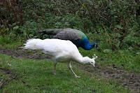
Barely past the few houses we almost walk into two male peacocks, their iridescent blue feathers glorious the early morning light. Naturally, by the time PC has her camera ready the birds had run for cover in a corn field. We wait. Patience pays off as a peahen and her chick emerge,which entices the males from cover. Then even more arrive, including a white one. Now we have plenty of photos and as we walk away we decide that the peacocks must outnumber the hamlet's inhabitants.


We continue down the road passing the beautiful autumn trees and rich smelling woody loam, hoping not to encounter any cars on this narrow stretch. Hard luck. Even on the tight hairpin bend at the bottom we have to wait for traffic.


We cross over to the out-of-use car park, check the notices to see if we still have access (we do) then plough on up the bridleway. The loggers are hard at work and the sound of their engines a constant drone through the should-be silence. At least they haven't made too much a mess of the path and the tall log piles of cut pine smells wonderful. Behind and around us the trees make a wonderful collage of honey, cinnamon, paprika and dark wintergreen; this is such a beautiful time of year.


We're getting warmer now, probably because the path has turned from hilly to mountainous. We don't remember it being this steep before! Maybe it's because we were younger and fitter back then. We press on regardless and pause to admire Foulstone Dike, it's shrouding curtain of trees removed by the loggers. It gives us chance to catch our breath too.


The path begins to even out and the moor is in sight. We're on Foulstone Road which only resembles as road up to the edge of the woods and as far as the house known as Foulstone Delf - possibly a quarry house - which stands above us. From here the road deteriorates into a moorland track, boggy in places, but which maintains a good width up the moor and was likely to have been a packhorse trail in the past.

It's a long steady pull up the track, the woods with the loggers are left behind us and the moor engulfs us. It's a bleak and lonely place, and so characteristic of this part of the Peak District. Today the far distant views are gradually opening up for us in a spectacular fashion, but on a cold, misty, murky day the unprepared could so easily find themselves completely lost.


We take our time, pausing frequently to admire a new vista, and having enough breath to continue talking. To our right are the grouse butts ready and waiting for the annual slaughter of brainless birds by brave gunmen.


We can't see Back Tor yet, the high point of the ridge, but soon we can see the tall marker stone at the cross roads on the moor. From here we can go down to Derwent Reservoir, along the edge towards Ladybower Reservoir or towards Back Tor. We choose Back Tor and head along the track that has been paved with huge slabs, grateful for the hard work done to keep erosion to a minimum and our feet dry. The peaty soil up here can be like a quagmire in wet weather.


We decide to by-pass Back Tor and head, instead, for Lost Lad which we have never visited before. We lose a little height first of all, then have to climb up again, but once at the top of Lost Lad (so named for a young shepherd who perished on the moors in a blizzard) the views are spectacular. We can see through 360 degrees and the sun is obliging too, making it all the more magical. There is a large cairn here, and a splendid memorial to a Mr Baxby, a keen walker. We sit down for a while to enjoy the views and the silence, and the secret flask comes out.


Too soon we see a herd of walkers approaching, so we drag on our rucksacks and head back the way we came. Looking back our still-warm seat has already been taken.


At Back Tor we look along the long ridge of Derwent Edge, but it is impossible to tell how far we have to walk. Still, we know it's a long way, so we set off determined to make the most of it. The path is easy to follow, either clearly grooved by many feet or flagged over the boggiest patches, and it is fairly level too. We've already reached the high point of Back Tor at 538 m and it's all downhill from here - even if it does take a very long time to lose any height at all.


The next major sight to greet us is the cluster of rocks known as the Cakes of Bread. To be honest, whoever named them had to have had an extremely vivid imagination or been very hungry at the time, although they are rather striking.


A little way beyond is Dovestone Tor where we decide to stop for lunch. We're both feeling peckish so we find ourselves a comfortable niche amongst the rocks and rummage in our rucksacks for food and coffee. As we start on our first cup of coffee the wind, which has been blowing gently all day, gathers a little more strength. We shuffle around to find a more sheltered spot but find that the wind is following us. Undeterred we finish our drink, start on our buns - carrot cake, all the way from Cumbria, which must count as one of our five a day. Feeling chilly we pour out our second cup of coffee only to find the surface of it being whipped into waves. Talk about storm in a teacup. We are liberally splash with coffee-spray and have to drink up quick. We don't linger, the wind feels vengeful and we're not sheltered enough to feel totally safe.


Once walking again we don't notice the wind quite so much, although it certainly cuts across the exposed ridge, but the cold is biting. We've seen a few walkers out today, but now they have all disappeared. A shame for them as the sun has now come out, lighting up the landscape but not actually warming anything up.


It is still a steady walk punctuated by small ups and downs. Ahead is the Salt Cellar rock formation and it's clear how it acquired its name, although it probably looks more like a pepper pot. To our right, in the valley, is the striking blue of Derwent Reservoir, dark blue today instead of murky grey.


We negotiate White Tor to see the impressive Wheel Stones ahead of us. These were clearly visible early on in the walk but the undulations of the ridge meant that we'd not seen them for a while. Now they're straight ahead and quite a size at close quarters. We have a look around them, shelter from the biting wind for a while, then press on.

From here the ridge curves distinctly SW and the decline is more noticeable too. We pause to photograph the reservoir below us, but the sun doesn't oblige leaving the hillside and water cast in shadow although even from our height we can see that the wind is rippling the water on Ladybower.


As we descend towards Whinstone Lee Tor we pass the Hurkling Stones on our left. They aren't, to be honest, very impressive, although there are some identically named stones a few miles away near Bradfield. Perhaps they provide more to look at.


We drop down to the crossroads of paths and feel the wind scything up the gap from Ladybower, and quickly turn east on the clear path towards Cutthroat Bridge. It's lonely here, only a few sheep and grouse to keep us company as we make our way on this very familiar route. We're usually taking this track in the opposite direction, but this way, downhill, is definitely easier. The light is mellower now, and the distant ridge of Stanage looks almost golden.


There are a few patches of bog for us to negotiate, this path has never been flagged, but we're soon past and on our way down the rocky track leading to the road. The waters of the small Highshaw Clough look particularly cold and fast flowing as they rush beneath Cutthroat Bridge.

We leave the moor behind us and trek the short distance up the fast A57 towards the lay-by. Everything is piled into the car and we head off to join the other car at our start point. We're a little stiff, quite tired and very cold but extremely satisfied. It has been a brilliant walk with wonderful views, and well worth the effort to do it.
