Despite predictions to the contrary yesterday's snow never materialised so it's all systems go for our much anticipated walk along Derwent Edge. Since this is to be our second attempt (see last week's blog) and aware of the distance we'll be travelling, we both manage to arrive at our meeting place early, pile everything into one car and set off for a small lay-by on the Strines Road facing Boot's Folly. It's snow free but not cold free and the arctic winds are making themselves felt. Undeterred we wrap ourselves up in as many layers as we possess and set off down the road to Strines. We're walking earlier than we usually actually meet up, so it's ten brownie points and a gold star each.
 We trudge along the road wondering if we'd overdone the layers, and soon we're in the sleepy hamlet of Strines and wonder, is it actually big enough to be called a hamlet?


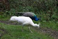
Barely past the few houses we almost walk into two male peacocks, their iridescent blue feathers glorious the early morning light. Naturally, by the time PC has her camera ready the birds had run for cover in a corn field. We wait. Patience pays off as a peahen and her chick emerge,which entices the males from cover. Then even more arrive, including a white one. Now we have plenty of photos and as we walk away we decide that the peacocks must outnumber the hamlet's inhabitants.
We continue down the road passing the beautiful autumn trees and rich smelling woody loam, hoping not to encounter any cars on this narrow stretch. Hard luck. Even on the tight hairpin bend at the bottom we have to wait for traffic.
We cross over to the out-of-use car park, check the notices to see if we still have access (we do) then plough on up the bridleway. The loggers are hard at work and the sound of their engines a constant drone through the should-be silence. At least they haven't made too much a mess of the path and the tall log piles of cut pine smells wonderful. Behind and around us the trees make a wonderful collage of honey, cinnamon, paprika and dark wintergreen; this is such a beautiful time of year.
We're getting warmer now, probably because the path has turned from hilly to mountainous. We don't remember it being this steep before! Maybe it's because we were younger and fitter back then. We press on regardless and pause to admire Foulstone Dike, it's shrouding curtain of trees removed by the loggers. It gives us chance to catch our breath too.
The path begins to even out and the moor is in sight. We're on Foulstone Road which only resembles as road up to the edge of the woods and as far as the house known as Foulstone Delf - possibly a quarry house - which stands above us. From here the road deteriorates into a moorland track, boggy in places, but which maintains a good width up the moor and was likely to have been a packhorse trail in the past.

It's a long steady pull up the track, the woods with the loggers are left behind us and the moor engulfs us. It's a bleak and lonely place, and so characteristic of this part of the Peak District. Today the far distant views are gradually opening up for us in a spectacular fashion, but on a cold, misty, murky day the unprepared could so easily find themselves completely lost.
We take our time, pausing frequently to admire a new vista, and having enough breath to continue talking. To our right are the grouse butts ready and waiting for the annual slaughter of brainless birds by brave gunmen.

We can't see Back Tor yet, the high point of the ridge, but soon we can see the tall marker stone at the cross roads on the moor. From here we can go down to Derwent Reservoir, along the edge towards Ladybower Reservoir or towards Back Tor. We choose Back Tor and head along the track that has been paved with huge slabs, grateful for the hard work done to keep erosion to a minimum and our feet dry. The peaty soil up here can be like a quagmire in wet weather.

We decide to by-pass Back Tor and head, instead, for Lost Lad which we have never visited before. We lose a little height first of all, then have to climb up again, but once at the top of Lost Lad (so named for a young shepherd who perished on the moors in a blizzard) the views are spectacular. We can see through 360 degrees and the sun is obliging too, making it all the more magical. There is a large cairn here, and a splendid memorial to a Mr Baxby, a keen walker. We sit down for a while to enjoy the views and the silence, and the secret flask comes out.
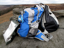
Too soon we see a herd of walkers approaching, so we drag on our rucksacks and head back the way we came. Looking back our still-warm seat has already been taken.
At Back Tor we look along the long ridge of Derwent Edge, but it is impossible to tell how far we have to walk. Still, we know it's a long way, so we set off determined to make the most of it. The path is easy to follow, either clearly grooved by many feet or flagged over the boggiest patches, and it is fairly level too. We've already reached the high point of Back Tor at 538 m and it's all downhill from here - even if it does take a very long time to lose any height at all.
The next major sight to greet us is the cluster of rocks known as the Cakes of Bread. To be honest, whoever named them had to have had an extremely vivid imagination or been very hungry at the time, although they are rather striking.
A little way beyond is Dovestone Tor where we decide to stop for lunch. We're both feeling peckish so we find ourselves a comfortable niche amongst the rocks and rummage in our rucksacks for food and coffee. As we start on our first cup of coffee the wind, which has been blowing gently all day, gathers a little more strength. We shuffle around to find a more sheltered spot but find that the wind is following us. Undeterred we finish our drink, start on our buns - carrot cake, all the way from Cumbria, which must count as one of our five a day. Feeling chilly we pour out our second cup of coffee only to find the surface of it being whipped into waves. Talk about storm in a teacup. We are liberally splash with coffee-spray and have to drink up quick. We don't linger, the wind feels vengeful and we're not sheltered enough to feel totally safe.
Once walking again we don't notice the wind quite so much, although it certainly cuts across the exposed ridge, but the cold is biting. We've seen a few walkers out today, but now they have all disappeared. A shame for them as the sun has now come out, lighting up the landscape but not actually warming anything up.

It is still a steady walk punctuated by small ups and downs. Ahead is the Salt Cellar rock formation and it's clear how it acquired its name, although it probably looks more like a pepper pot. To our right, in the valley, is the striking blue of Derwent Reservoir, dark blue today instead of murky grey.
We negotiate White Tor to see the impressive Wheel Stones ahead of us. These were clearly visible early on in the walk but the undulations of the ridge meant that we'd not seen them for a while. Now they're straight ahead and quite a size at close quarters. We have a look around them, shelter from the biting wind for a while, then press on.

From here the ridge curves distinctly SW and the decline is more noticeable too. We pause to photograph the reservoir below us, but the sun doesn't oblige leaving the hillside and water cast in shadow although even from our height we can see that the wind is rippling the water on Ladybower.
As we descend towards Whinstone Lee Tor we pass the Hurkling Stones on our left. They aren't, to be honest, very impressive, although there are some identically named stones a few miles away near Bradfield. Perhaps they provide more to look at.
We drop down to the crossroads of paths and feel the wind scything up the gap from Ladybower, and quickly turn east on the clear path towards Cutthroat Bridge. It's lonely here, only a few sheep and grouse to keep us company as we make our way on this very familiar route. We're usually taking this track in the opposite direction, but this way, downhill, is definitely easier. The light is mellower now, and the distant ridge of Stanage looks almost golden.

There are a few patches of bog for us to negotiate, this path has never been flagged, but we're soon past and on our way down the rocky track leading to the road. The waters of the small Highshaw Clough look particularly cold and fast flowing as they rush beneath Cutthroat Bridge.
We leave the moor behind us and trek the short distance up the fast A57 towards the lay-by. Everything is piled into the car and we head off to join the other car at our start point. We're a little stiff, quite tired and very cold but extremely satisfied. It has been a brilliant walk with wonderful views, and well worth the effort to do it.


