Stanage
Showing posts with label Fin Cop. Show all posts

Monday, 3 November 2014

MURKY AT MONSAL

We seem to have stumbled upon a pocket of murky weather in the midst of fine clear days; typical luck for us!


Today we are revisiting a familiar walk, but in reverse, and park up at the side of the Longstone road at Monsal Head. There is a thin fog all around, not sufficient to block the view entirely but it makes everything a little hazy and damp. Knowing that rain could fall at any time we decide to pull on our waterproofs to be ready.


We set off to the top of Monsal Head then take the left hand path signed Monsale Dale which descends gently through the woods. We pause at the weir then follow the path to the bridge where we cross over.


I have spied cows so am on the alert! However, that doesn't stop us standing by the side of the river to watch the white-chested dippers busy on the water. And to have a nip of my latest concoction - Blackberry Vodka. Very warming!

Overnight rain has made the paths muddy and wet but we are surprised that there are not more people out. It is half term, after all. PC has a (totally justified) rant about people hanging bags of dog poo on the branches of bushes - seriously, what do these misguided idiots think is going to happen? Do they think wardens will follow them around to clean up their mess? Town mentality in a country setting.

Just before we reach the end of the Dale at Lees Bottom we take the right hand path which climbs up out of the valley. It is warm work so we have to remove a layer before continuing. The path is quite steep - we are more used to descending than ascending - and the rain has increased the potential for slipping though we reach the top without mishap.

Here there is a deal of scrub before the path scoots around to the right, so we find ourselves a mound on which to sit and eat lunch. We are pretty sure we have sat here before, though there isn't a great deal of a view.

The sandwiches are unremarkable, the coffee is good but the buns are excellent - fat choux buns stuffed with fresh cream with chocolate swirled on top. Definitely the highlight of the meal.

We experience a brief, unenthusiastic shower of rain (easily ignored) and a visit by a charming Dalmation (it's owner suitably apologetic but the dog wasn't a slobbery pest so it was fine).


Then we hoist ourselves up from our seat and press on. The next obstacle is the high stile over the wall at Brushfield Hough. Normally this wouldn't present a problem but since I have trapped a nerve in my back the height of the step is a significant problem. Eventually, with much grimacing, cursing and gritting of teeth I am over, and PC follows majestically.


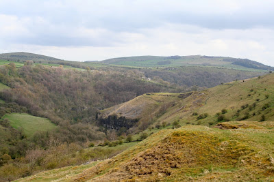
We pass through the fields, a gate and then the farmyard of Brushfield Hough before taking the track out of the yard and to the path following the ridge. The rain has cleared the sky so we have a good view of Fin Cop across the valley as well as a good view of the valley itself.


The track is reasonable until we reach a long, wide flooded area. Rather than paddle through - and it would be over our boots - we spy a path in the next field that has been made to avoid this clearly permanent feature.


It's easy walking now, until the long steady downhill which is rubbly and uncomfortable underfoot. However, this soon gives way to a softer surface again, and as we descend to Monsal Viaduct we hear children shouting and the sound of harassed parents. Ah yes, half term.

The viaduct is crammed with people, walkers and cyclists. We have never seen so many people on here at once before. Most seem to be using the tunnels and riding or walking a long stretch of the trail, but we turn left off the bridge and onto the path that leads up to Monsal Head.

Once here there are, again, loads of people and the ice cream van is doing a roaring trade. Well, the weather isn't too bad now, and is isn't too cold so they are clearly making the most of it.

We go back to the cars and plan our next walk, preferably without any very high stiles!

Thursday, 3 May 2012

WET WEATHER ON A MONSAL HEAD CIRCUIT

Right, the Easter break is over and it seems half a lifetime since we were last walking so we're especially keen to be out today. However, it is raining, and has been doing so for quite a few days and at a considerable rate. We fully expect to get drenched.

We drived through heavy rain, light rain, drizzle and threatening clouds to arrive at Monsal Head, parking up on the road rather than using the car park and falling foul of the parking fees and potential to outstay our (paid for) welcome. Our first discussion - after the 'yippee, we're free' moment of glee - is a debate as to whether we don waterproof trousers now or later. We look up at the clouds and choose now. Within a few minutes it's raining again.

Along with our gear today I've included a large umbrella. It might seem a strange thing to take hiking but if Nicholas Crane (Coast) can do it, so can we. But with more style. There is a method in the madness here. Any downpour leaves us cowering beneath hoods that cut off all decent conversation, drip water down our faces and obscure vision. Also even the best waterproof coats let in some wet when constantly chafed by rucksack shoulder straps. Hopefully the brolly will prevent this. PC reckons it will be ideal for sitting under at lunchtime - she certainly has her priorities straight.


Off we go, a spring in our step, to Monsal head and after the briefest of pauses for a photo we head off. Only once we passed through a gate and are still on relatively level ground do we realise that we've taken the wrong path. Duh! Too busy talking and not enough paying attention. And it isn't as though we haven't made the same mistake in the past, so no real excuses other than that we're so giddy with excitement at being out. We backtrack quickly and take the proper path down to the viaduct. Mollie is let off the lead to scamper in front terrorizing stones as we need to be careful on the slippery limestone.

At the bottom of the track we're out onto the Monsal Head Viaduct, and we're in for a surprise. Headstone Tunnel, closed for so many years, is now open! A couple were coming through as we looked on and we stopped for a chat. It appears that the other tunnels along the trail have been opened too with lights (on at dawn, off at dusk) in the longer ones. There is a possibility, in winter particularly, that the tunnels may have to be closed at short notice, and for anyone wanting further details please check the following website:  www.peakdistrict.gov.uk/visiting/cycle/monsaltrail  It gives information for walkers, cyclists and horse riders.

On with our walk, we cross the viaduct and turn left through a gate and start to climb uphill along a rubble strewn path. It's raining, but not too bad so we keep pausing to enjoy the views behind us. After a while we pause for a bit longer, to remove a layer of clothing. It's warm work walking uphill.

We pass through a small belt of trees and out into the open, still climbing but we know the top isn't too far away. Four soggy walkers pass us going downhill, and these are the last people we'll see until returning to the Trail at the end of our walk.


Once we're at the top of the climb we know we've done the worst of the walk. We've reached the easy-to-walk track that will take us towards Brushfield and skirts the aptly named area of High Field. It's pretty exposed up here and the rain is coming in bursts. The brolly is being put to good use, but it's a good job it isn't windy.Across the valley is Fin Cop Iron Age Hillfort (plenty of info on the web) but it is pretty much shrouded by sheets of rain. Closer to us, however, is a field with cowslips so PC goes into photographer mode and is down on her knees to capture them on film.


Back on the track we have to skirt a few path-wide puddles but none present much of a problem. The rain can't really make up it's mind and we seem to be having a couple of minutes clear then a couple of minutes wet. So far, though, we haven't had a deluge.


We come to a crush-stile next to a gate, and after I've squeezed through the crush PC calmly opens the gate for the easy option. We ignore the left hand path to Brushfields Hough, which we've taken in the past, this time carrying on straight ahead. The track dips a little and takes us towards some trees. Now it starts to rain as though it really means it. Perhaps we shouldn't have mentioned not having had a deluge.


At this point we're somewhere above Taddington Dale and the main A6. Although we can hear some traffic noise (not much over the sound of the rain) we don't pause to attempt to look at the map - the map-cover is liberally covered with raindrops obscuring all details beneath.


  We go through another gate to find ourselves on the approach to Brushfield, a very attractive collection of farms and cottages, all very neat and tidy. One in particular has a small but beautifully tended garden which makes us pause in admiration. At the end of the driveway we turn right and are once more going uphill. We pass Middle Farm holiday cottages (they look very nice) and continue along the track to Top Farm. Despite the lack of signposts we guess we're on the right path, following it behind the farm buildings to come out above High Dale. The rain has stopped again giving us some excellent views.


It's a straight, easy path again with a few dips and rises although in one dip the whole path is covered in water. We manage to skirt it on a high verge that is very muddy and are soon at the other side. A quick wipe of the map-cover to check the map and at the top of the track turn right to climb over a stile (one of the awkward ones with a tiny gate on top). We've just entered Priestcliffe Lees Nature Reserve (SSSI). The only nature we can see at the moment are a small flock of soggy sheep running away from us.

We're in a long, narrow field with a series of humps and hollows, which may be evidence of past lead mining. The path takes us downhill, through another stile then into another, larger field with more humps (fewer hollows). These are lead spoil heaps and provide a special place for wild flowers, which we see straight away when we spot clumps of wild yellow pansy. Even on a soggy day their small flowers are so cheerful.

This is a perfect spot for lunch, especially since the rain has stopped, so we find a suitable vantage point to sit down overlooking distant Litton Mill with Millers Dale on the right and Tideswell Dale to the left. Out comes the Ramblers - we've earned it today - followed by sandwiches and buns. Our post holiday treats are lemon scones - plain scones with lemon curd and fresh cream. Yum. As we start on our first cup of coffee the rain starts, so up goes the umbrella and we sit there snug and dry waiting for it to pass. We wait, and wait, and wait. After the second cup of coffee the rain eventually abates so we pack up our gear ready to set off.

Within a couple of minutes the sun is out; full, bright spring sunshine that makes us start to steam. But not for long. A couple more minutes, on the slippery downward slope, and it's raining again. By the time we reach the stile leading to the Monsal Trail at Litton Mill it's pouring. Five more minutes and we've crossed the trail to descend to the bridge spanning the very wide, full, fast flowing River Wye - and the rain has stopped again.


We turn right at the end of the bridge over the river and walk past the old mill buildings to take up the path at the side of the river. The last time we were here the river was calm and clear, not so today. It is an angry river, although a brown and white Dipper doesn't seem to be the slightest bit troubled as it skims the fiercely flowing water to land on a rock in the middle of it all.

This path is wide, level and so easy to walk, perfect on a good day for just about every member of the family, but fairly popular at any time. We don't even wonder why there are no other walkers on this path today, until we round the bend towards Water-cum-Jolly Dale and find that the path has disappeared. It is all under water. Not a happy prospect near the end of a walk!


At first we scout next to the cliff to see how deep the water is - very. Almost up to Mollie's belly. Then PC decides to try the submerged hedgerow/verge next to the river and pond. It's one of those hold-your-breath moments as she slowly feels her way along, using her walking poles to guage the depth. She sees clear path ahead, around the bend, but there's a lot more water to get through first and we don't know how bad the path is further on. I'm not keen as we still have quite a distance to go.


Then a walker on the opposite side, high up on the cliff, shouts down to us that the path is completely submerged further on too. Thank you walker in the blue jacket, you saved us finding out the hard way. We now have no choice but to back-track and make our way to the road. It's going to add a considerable time to our walk, but it can't be helped.

However, a little way back I spot a sign at the side of the path (unnoticed in the opposite direction) and it's pointing out an alternative route for 'when the path is flooded'. Obviously a regular occurrance. The alternative, though is a steep uphill climb over slippery smooth limestone. This calls for good boots, stamina and handholds. Mollie, naturally, thinks it's a perfect place for finding stones and rolling them downhill. Under our feet. One way to become a very unpopular dog!


 The climb is short and sharp but we're soon well above the river. The path leads us to a stile (a fence rail with a stone on either side - handy if your legs are long, not so good if they aren't) and a field skirting Cressbrook Hall. Wow. What a gorgeous house. We've seen it before from the opposite sideof the Wye valley, but it is far more impressive close up. The path passes a sloping bank on which there are primroses and in a wooded area we see the first bluebells of the year.


The path takes us around the edge of the hall then down a steep step to follow it through the light woodland towards Cressbrook Mill. We're walking through ramsons here though they aren't in flower yet so their heady garlic scent isn't apparent. It seems that the path will take us right down to the water's edge again but instead it veers left and leads us out onto the road instead. No problem with cars today, though, as there is a 'road closed' sign higher up.

We walk down the road and choose to take the path through the Mill towards the huge pond at Water-cum-Jolly Dale to see how high the water is. Very! It's pouring over the weir in a torrent and we can see - or rather, can't see - where the path is completely submerged. It will take a time for that to clear.


We cross over the bridge, aware of the sheer volume of water rushing beneath our feet, then climb up the steps to the path. It's raining again - naturally. Soon we're heading back towards the Monsal Trail along the single-file track on the hillside. No one on it today - not surprising given the weather although it is more likely because the tunnels are now open and people don't have to negotiate this stretch.

Once back on the trail we're passed by two cyclists (are they cyclists if they are laying down on their bikes which have 3 wheels) whizzing along at a cracking speed. We walk along at a more sedate pace although it doesn't take long for us to reach the final climb up towards Monsal Head.

The sky has cleared at last and as we make our way back to the cars we're debating on where to go for our next outing. We're still undecided, so it will be a surprise for everyone. Just hope that the weather improves.

Monday, 9 May 2011

BLUEBELLS ABOVE MONSAL DALE

Since the beginning of the school holidays we've been experiencing hot, sunny, dry weather so it was quite disappointing to wake up to grey skies for our first walk after the Easter break, but by the time we met up at Monsal Head it looked as though we might be lucky. So we packed the sun cream along with our waterproofs - just in case.

As always, we have to stop at Monsal Head to admire the view down the length of the valley before we walk down the sloping path to the viaduct. Once on the viaduct we have to stop again, this time to admire the view to Caer Paravel (PC having one of her artistic turns) although today the rocky crags she likens to the fictional castle do look very fortress-like.

Once across the viaduct we take the gate to the left then head uphill on the bridleway which, in turn, leads onto the old quarry road. Here we see our first wild bluebell, so PC duly captures the shot for posterity. Later on we see many more, but this little gem is special.


It's quite a steep track so we have a few pauses to study the sloping hillside at Upperdale across the valley. At this point we're discussing crystal therapy and by the time we reach the top of the slope our conversation has turned to aromatherapy.

We're soon through the gate across the track and we sneak over the broken-down drystone wall on our left to get a better view of Monsal Dale below us, where the river is surprisingly high given the lack of recent rain, and the iron age settlement of Fin Cop across. An archaeological dig has been taking place at Fin Cop which has lead to the discovery of bodies thrown into a ditch, an event reported in the national press and which may lead to a re-think about the use of these sites in ancient times.

Back to our peaceful walk where we can amble easily on the level hill-top track. Easy walking makes for easy talking but even we're amazed by how soon we reach the turn that takes us through the farmyard at Brushfield Hough.

There are cattle in a barn happily eating and mooing, and PC gets closer to take a photo. I, naturally, keep as far away as possible.


A sharp left turn between two buildings, through a gate and we leave the farm behind. The path follows the farm track for a short distance before heading over a stile in the wall. For a change I'm struggling (with sciatica) as PC bounds over the stile like a graceful gazelle. (Well, perhaps not quite like a gazelle, but you get the picture.)


We've made such good time that we hunt out a place to sit for coffee, and park ourselves on a grassy stretch of the shrubby slope overlooking the A60. Except that it doesn't actually overlook the road as there are too many trees in the way (thankfully) and we can hardly hear any traffic either. We're surrounded by birds, flowers, trees and industrious insects including some small black and white striped bees.


By now the sun has come out and as we sit with our coffee we fetch out the sunglasses too. It's too good a place to move from, so we natter (exams, education, dreams, Prof Brian Cox - not necessarily in that order and not, I hasten to add, related to each other in any way!) and soon we realise that it's actually time for lunch.


Out come the sandwiches and the buns. These are apple and cinnamon muffins from BBs - currently considered to be the best muffins ever, though we're open to suggestions and tastings for other contenders. With the last of the coffee finished we make ourselves comfortable, lay back and soak up the sun whilst allowing our conversation to ramble on, and on, and on.


It would be very easy to stay here and snooze in the afternoon calm, but eventually we manage to drag ourselves upwards and onwards - or downwards as it's all downhill from here.


We enter the woods and sweet perfume of bluebells rises up to greet us. We see great swathes of them beneath the trees and risk injury from low branches as we push through the undergrowth for a better view and some photos before getting back on track.


By this time we're talking books and literature - what an enlightening day we're having!


At the bottom of the hill we turn left to follow the river. There are often cattle grazing here but fortunately (for me) there are none today. We pause to look at the half buried remains of an old water wheel, but detour to avoid a fisherman who doesn't seem to be having much success. The river is clear and tranquil and PC spots a trout in the shallows - a long way from the angler.

We startle a moorhen in a tree - yes, honest - and pause to admire the shy peach-coloured geums growing prolifically in clumps and marsh marigolds in the middle of the river.


We cross over the river at the footbridge beneath the weir, but not before pausing to admire the spectacular water cascading over it. Then it's the start of the slow uphill climb towards Monsal Head. In the woods there are more bluebells, geums and sinister green arums.


By the time we reach the top there are plenty of people about. We don't stop though, we spent too long earlier and now we have to get going.


We don't walk in the White Peak as often as the Dark Peak, but maybe we're missing something. Today the flowers have been so special - and the cows have been behind fences!

Wednesday, 13 October 2010

ASHFORD IN THE WATER, DEEP DALE, SHELDON


Having missed a week's walking desperation has me turning up at Ashford in the Water's tiny car park ridiculously early. It is foggy and I have a long wait. An uncharged camera and milk boiling over conspires to make PC late. Ah well, by the time she arrives the weather is picking up a little and we can at least see where we're walking to.

We set off through the village and over the picturesque medieval Sheepwash Bridge which spans the River Wye, pausing long enough to take a photo (I had brought a camera though wasn't quite sure how to work it) and admire the ducks braving the cold water.We cross the main A6 and walk along it for a short distance before turning off onto the road leading to Sheldon, although we are soon taking a footpath to our right which follows the winding river.

By now our initial giddiness at being out has passed and our talk has turned to more serious things. Radley handbags. Women will understand, men undoubtedly won't.

The level path isn't as muddy as we had expected as we pass Little Shacklow Wood on our left and head towards the derelict water powered bobbin mills. Here bobbins were made from the local ash woods to be used in the cotton making industry, such as at nearby Litton and Cressbrook Mills.

Today a group of anglers are parked outside the mills preparing for a day on the river, so we walk on by without pausing and take the broad track that runs behind the buildings, admiring the rusted waterwheels and old stonework.

We have now entered Great Shacklow Wood and are hoping to enjoy the autumn colours as the sun is now breaking through. Before the path begins to climb we come across a large pond playing host to numerous water birds. This pond is the collection point for Magpie Sough, the drainage tunnel from Magpie Mine high up on the hills behind us beyond Sheldon. Although blocked in the 1960s it has since been cleared to run freely again.
From here the path begins to climb, quite steeply in places, and it's time for us to pause to admire the golden trees - and remove a layer or two. Time also to test the contents of the secret flask. Yes, all in order.


The flask obviously helps as we reach the top of the path sooner than anticipated before dropping down to the head of Deep Dale where there is evidence (although we didn't see it) of a settlement and cave shelter. There is also evidence (clearly visible) of cows. Lots of them. But since they aren't to be seen I concentrate instead on the views - excellent behind us over the River Wye towards the Fin Cop settlement on the far hill, and closer to the stark white limestone amongst the green and brown vegetation. The path is dry but rough underfoot as cloven hooves have dug up rocks and pebbles. At times this supposedly dry valley can be a quagmire but despite recent rains it isn't bad today. But it is warm now, so we remove yet another layer. As we press on PC suddenly instructs me to 'Keep Walking'. Naturally, I stop and looking around see a herd of cows on the slope directly above us. Resisting the urge to scream and run I remain calm and, with PC uttering soothing words to me all the time, we press on only a little faster than usual.


Danger passed we spy a large clump of blackthorn with fat juicy sloes still on the branches. It hasn't been a good year for sloes so this is an opportunity not to be missed. We down rucksacks, rummage for something to put the sloes in, and start picking. It's very therapeutic - despite the vicious thorns - and brings out the self-sufficient peasant in us. It doesn't take too long to gather enough to make a bottle of sloe gin each, and PC decides to have a go at making some herself. We'll taste and compare when they're ready - all in the interests of serious study, naturally.

It's turned cooler again but we're buoyed up by the thoughts of the gin - and of the raspberry gin, raspberry vodka, gooseberry gin, and mixed berry vodka all underway at home, plus the gallons of cider and Ramblers' Restorative (the contents of the secret flask) already made. We start making up names for them all, until we see more cows ahead. What is it with this walk and cows?

This time I'm not feeling so brave so I manage, with agility borne of desperation, to climb over a wall and squeeze under a wire fence to avoid them. Seeing my gymnastics PC decides the cows are less of a threat and walks right past them. They don't bat an eyelid but I know that they would have charged us and stampeded if I'd been there.After our adventures we're feeling hungry so find a hollow of ground and settle down for lunch. We have to pull on coats and jumpers as the sun has gone and it has turned chilly. Heavy salads are followed by welcome coffee and the buns. Today's offering: Lemon Muffin Cheesecakes. Mr Morrison has done us proud. They are sooo good. Biscuity base, fluffy cheesecake with lemony centre topped by muffin pieces. Bliss.

Feeling extremely full, but cold, we press on through a close-cropped field of sheep to the gate which leads onto the unmade Wheal Lane. There are cows (again!) in the field to the side of us, but they're behind a stone wall so pose no threat. At the top of the track we emerge onto Flagg Lane, a minor road which runs between Moneyash and Buxton. Here we debate what to do next. We can follow the road then turn left into Sheldon, or we can cut off the corner and go through fields. The road is the least appealing option, but the potential for a bovine ambush in the fields cannot be ruled out. Finally we decide to go the field route, with PC volunteering to be the cattle wrangler if necessary. I, of course, will be sprinting in the opposite direction!

There are cows in the first field, far enough away not to be a problem, but we cross at high speed anyway and squeeze through a tight crush-stile. We're both pleased to be able to get through so easily - shows how slim we are. The next few fields are fine and we're becoming blase, despite the increasingly dodgy stiles we have to negotiate. Then, with only two fields to go we see them. Cows. Hundreds of them. All across our route.

After some dithering we set off across the first field. These cows are only young, curious and a little afraid. I'm over the stile in record time but the next field is more problematic. It's full of friesians, all in the bottom half, next to the road and our escape route. Across the field is an electric fence. If it is switched on we'll not be able to get through anyway, and the thought of walking all the way back is even more daunting (at the moment) than the prospect of walking though cows.

We approach the fence cautiously. It doesn't appear to be connected. PC risks electrocution by tapping it with her stick. No, she's still alive so we limbo underneath the wire (honestly) and face the cows. Some of them are looking at us and others wander onto our path.
Decisive action is required which involves walking at speed with PC between me and the beasts, head down and trying not to see them. As we approach the gate the cows are milling around but I've spotted a gap and am sprinting for the stile before PC even knows I've gone. onto Johnson Lane taking out the camera before PC is over the stile. Photographic evidence is essential.
With the cows now behind us we walk up the lane into Sheldon as the sun shines on us again. A good omen.

There are a number of cars parked on what appears to be the village green,a group of walkers, and we wonder what the villagers think of having their space commandeered in such a thoughtless manner.Then we see them. More cows, this time being herded up the main street. I don't believe it! I take refuge behind a bench as PC stands suicidally in the middle of the road to take a picture

Once the cows have passed we walk though Sheldon, a pretty unspoilt village. It still seems to be a predominantly farming community although there are some lovely cottages and it was once home to miners working at the nearby Magpie Mine. There is an interesting looking pub, the Cock and Pullet, which has been marked down for a future visit.

As we walk we discuss the possibilities of alcoholic jams and marmalades, debating which liqueur will go best with which fruit. Experiments are in order.

The road drops down and we round the bend before taking the path off to the left which runs along a grassy, sloping field with the woods ahead of us. With the afternoon sun shining the leaves on the trees in Little Shacklow Wood seem to be glowing. This is early autumn in all its glory. We skirt the edge of the wood and as we do the vista opens up ahead of us so that we can see a huge distance.

We leave the wood and start to descend steeply across open ground towards the River Wye. It's hard on the knees but soon we're at the bottom and able to retrace our steps to Ashford. With the sun shining we pause for more photos at the bridge, then it's a quick walk back to the car park and the end to another very satisfying day - apart, of course, for the cows.
