Stanage
Showing posts with label Hope Cross. Show all posts

Monday, 6 March 2017

A LONG WAY TO HOPE CROSS

We've decided on something a bit more challenging today. For too long we've been playing safe, acutely aware of our lack of fitness and time constraints. So, enough of that, today we're making the most of it!

We squeeze into the full lay-by next to Yorkshire Bridge Inn and start off with our usual swapping session (including an old fashioned ginger beer plant). It starts to rain so we wait it out with a piece of Key Lime Pie and a drink of ginger beer. That sets us up nicely, then it's onward and onward.

We cross over the dam wall and look down it's chilly length. There's always a stiff breeze blowing here, but we suspect that there'll be little good weather today.


We turn right and set off at the side of the reservoir. We haven't gone too far before we reach the track we usually come back down on and make the decision to go up that way instead and do our walk in reverse. Well, it seems like a good idea!

We go up, through the gate at the top, and pause. Is it an age thing? We can't remember how we usually approach this point - and we've been here loads of times. The map is of minimal help, the paths on paper not quite matching those on the ground.

We strike off to the right and then veer left, eventually going through a metal gate. The first wisps of familiarity disappear as we realise we have never been here before. Never mind, it's going in the right direction, more or less.


The path is quite boggy in places, and brings us to an old derelict building. It has wonderful views, but poor access and needs a bit of work doing to bring it up to modern standards!


We head on upwards and come to the fence line beneath Win Hill. We may not be on the path we planned but we've arrived where we need to be.

From here it's a long walk following the line between moorland and forest. In places it is waterlogged, in others it is stony underfoot. 


The path undulates with some quite large dips and rises and we even get a glimmer of blue sky, but it doesn't last. The views from here, though, are superb.


Further along we have a number of options; go down, go on, go to the Roman road, go backwards and up Win Hill. The sheep scrutinize us as we quickly decide to keep going. We'll reach the Roman road soon enough, and our target is Hope Cross.


And after more walking than we recall (why are distances distorted when you do a route in reverse?) we see the cross standing aloof next to the path.


We only pause briefly to look at it before finding the path into the woods. At last we find something to sit on out of the wind to enjoy a late lunch. The Key Lime Pie and ginger beer certainly kept us going! Today's treat is scratched cinnamon swirl bun. Nice and chewy, but I would have liked more cinnamon.


Once we've done we head off again, it's too cold to linger. We're going steadily downhill now, and past the ridge and furrow land under the trees. They look very ethereal given the dark gloom of the woods here.

At the bottom we turn right through the muddy patch that was once the front yard of another derelict building. There's heavy moss growth on the old gateposts and a sense of nature reclaiming everything.


We walk through the trees, and the views open out again. It's downhill and a bit muddy, and we're surprised how far we still have to walk - this is usually behind us on the outbound stretch so it's not our usual view.


It's levellish ground though, and no challenge, especially as we still have plenty to talk about (nothing new there). But the sky is dull and we've had the best of the day. No pause when we get back to the cars, it's been a long walk and we can't hang around. But it's certainly been worth it.


Saturday, 10 December 2011

ABANDON ALL HOPE


FROM HOPE TO WIN HILL IN HIGH WINDS, SLEET AND RAIN

First of all I must point out that this week's walk was all PC's idea, and she must take full responsibility for it. Even her suggestion when we meet, before 10am, that 'we go to the pub for the day' does not absolve her in any way.


We've had a week off and our last walk, which was windy but mild, had lulled us into a false sense of well-being. Since then we've had snow, rain and gales so on the drive to Hope we aren't surprised to see the peaks liberally covered with the white stuff. And the forecast isn't promising: gales in Scotland, possibly filtering down to us later. Hence PC's suggestion that we sit out the day in the pub. Tempting, but she isn't getting off that easily. So we layer up, consult the map and set off.


At the moment there isn't any rain and although it is cold there's barely a breeze, so we're feeling fairly confident. We walk up Edale Road and turn right onto the small road leading to the cemetery. We cross the bridge spanning the River Noe which is flowing fairly fast, ignore the path running alongside it and take the next right hand path which takes us past the cemetery.


The path goes through a gate then underneath the railway line. From here the wide path takes us gently uphill and past a neatly kept patch of land that looks like a small site for caravans. Sure enough, when we arrive at the top of the path and pass Fairfield Farm we see the sign at the end of the driveway that indicates a Caravan Club CL site (5 caravans only). That's one worth remembering.


At the end of the drive we turn left onto the narrow road leading towards Aston and it's a little more noticeably uphill. By the time we take the left hand turn (signposted Hope Cross) PC is removing a layer. We wonder if this part of the old roman road, but careful study of the map makes it seem unlikely as the road appears to be lower down.


We press on uphill and start to see the wonderful views over towards Mam Tor and Lose Hill with their snow covered tops. We're so glad we aren't up there this week!


At the top of the tarmac lane we turn left onto the rough track which leads up - eventually - to Hope Cross. A fat squirrel crosses our path and scurries away as a ginger cat eyes us suspiciously. Do they know something we don't?


The first section of this path is very stony, and wet. It's a sign that there's been a lot of rain lately as there are rivulets of water running downhill, but it's easy enough to avoid the streams and we continue dry-shod. There are trees to our left, sheltering us from the view of the cement works (thank goodness) but every now and then there is a break which gives us ever-improving views towards the snowy peaks of the Great Ridge.


An abandoned, ruined farm building hunches at the side of the path, then we go through a gate and onto a path which cuts across a rough field. It is slippery, slick and muddy and although the uphill gradient is minor it takes effort not to slide around too much. At this point we are unaware that worse is yet to come!


Above Twitchill Farm and at a crossroads of paths, not very distinct but there is a signpost, we pause to admire the views - and the gathering clouds. PC snaps away with her phone (did I mention that she forgot the camera?) and we agree that it is wonderful to be out enjoying such glorious scenery. After a brief debate we decide to continue straight on rather than climbing steeply uphill towards Win Hill, as we want to enjoy the vista opening up in front of us.


Apart from the slippery ground the walking isn't hard and we find it easy to avoid the numerous puddles on the path. We pass through another gate and we're finally onto open moor. It's a little bit breezy here, but nothing to worry about. It's a steady but easy climb and we've made the right decision as we can now see beyond the Great Ridge to the Kinder Plateau which looks spectacular with drifts of snow emphasising the contours of the land.


We feel a couple of spots of rain so PC decides to put her coat back on, and when I see the rapidly looming grey clouds I follow suit by dragging on my waterproof trousers. Just in time too. Almost as soon as we're dressed we're hit by rain, sleet and hail. And wind. Where did that come from all of a sudden?


We press on uphill expecting the wind to ease, but it doesn't. Nor does the rain and sleet. The higher we go the harder it is to keep our footing as we're constantly being pushed sideways into the hill. For once talking has ceased as we keep our heads bowed and plough on.


As we hit the top of the path we're struggling to stay upright. The wind is so fierce that we are seriously beginning to doubt our sanity (not for the first time) but there's no turning back. The Kinder Plateau is completely obscured by ominously thick clouds and it's impossible to look in the direction of Mam Tor because that is where the driving sleet is coming from, so it doesn't look as though we're in for a respite.


Turning towards Win Hill we set off again; one step forwards, two steps sideways. Enormous puddles cover the width of the broad path and rivers link one puddle to the next. We manage to avoid them, but we have to use sign language to communicate as we can't make ourselves heard over the wind. We've reached the snow line too, with slush on the puddle-free sections of track and white fluffy sheets on the heather.


After a while we realise that the sleet has stopped and bracing ourselves against the wind (which hasn't stopped) we turn around 360 degrees to admire the view. PC spies Ladybower reservoir looking full for a change, and across the valley Crook Hill looks stark and uninviting. To the north-west we can see the roman road heading to Hope Cross. Strangely enough, there are no other walkers on this popular path. I wonder why not?


There's a long wall crossing the path with the option of a stile or gate. Naturally we choose the gate, and at the far side we fall gratefully into the shelter of another wall which runs at the side of the path. At last we're able to stand upright without effort, though our leg muscles are aching with the unaccustomed requirement to fight for balance whilst walking forward. As we rest we reward ourselves; cointreau from PC's secret flask (it's easier to get to than mine). A couple of hefty nips soon makes everything seem warmer and rosier.


Walking is a lot easier now with the benefit of the wall on the windward side, and the cointreau on the inside. However, as soon as we lose the wall we're completely exposed again and the full force of the gale makes itself felt. Win Hill doesn't look terribly promising so we prudently decide not to go right over top but keep to the path which skirts around the southern side. Before we reach it, though, we see two other walkers coming up from the south and heading right for the summit. They manage it so far, then turn and hunker down on the leeward side against the wind.


As we approach the slope of Win Hill it becomes increasingly difficult to stay upright. Every footstep has to be carefully judged but every pause is punished by the hammering gale. Its a case of heads down, watch your feet and don't look back. Just below the trig point I manage to sit on a boulder to wait for PC to catch up. When she reaches me she sits on another boulder a little higher up. After a brief break we have to fight to stand up and regain our balance before setting off again. Tempted to look back at the view I'm almost knocked off my feet, so I carry on, but PC is more successful and manages to take some photos. She's not sure she's been able to keep still enough, though, since the wind was rocking her so much.

It's downhill now, but quite worrying as the steeply sloping steps are covered in snow, slush and running water. I make it to the bottom first and wait for PC to catch up (she's been taking pictures), then we continue down towards Winhill Plantation. All of a sudden the wind stops. Completely. Under no illusions we know that we have dropped down sufficiently to be protected by the lay of the land, but it is very strange to suddenly be able to hear, talk and stand upright without effort.


We pause to consider our options. Namely, we're hungry and need somewhere to sit for lunch. Fortunately, just in the edge of the plantation are a couple of fallen trees, so we cross the snow and heather towards them. It's a perfect spot; sheltered with seating provided.


Sandwiches are dispatched with alarming speed, followed by a warming cup of coffee. PC suggested leaving the buns until later, but we're too hungry, so out they come. These are a first. Pear tarts - buttercrust pastry with half a pear and a frangipani sponge. They taste wonderful and are extremely satisfying.


As we finish off our buns, and our second coffee, a bedraggled group trudge up the path towards Win Hill. Most of them seem to be well equipped but a couple are without rucksacks or waterproofs. They'll be in for a serious shock when they climb out of this sheltered buffer zone.


Even though we're out of the wind here it is getting chilly, so we don't need much encouragement to pack up and move on. We return to the path through the snow and continue downhill where, instead of going through the gate and down Parkin Clough, we turn right across the moor.


No sooner are we out of the cover of trees the rain starts again, and looking at the grey expanse of cloud it seems that it will be set in for a long time. There's more wind here too, so we're treated to the double-whammy of stinging rain being blown into our faces. Lovely - not. We risk looking back towards Ladybower, but there's too much rain to see clearly and all we can make out are a few murky shapes.


Heads down we walk on. The path is grassy and level, but soggy and very exposed. Parts are flooded and we have to detour through the heather. Soon we come to a signpost where we have to turn right and cross through a broken section of drystone wall as we take the path signposted 'Aston'. The first part is narrow but it widens as it goes sharply downhill between high banks.


As we reach the bottom and prepare to climb over the stile in the wall (very long legs required) the weather takes a sudden and dramatic turn for the worse. Snow and sleet on a driving gale hits us squarely and forcefully. Visibility diminishes to a few feet and all we can do is turn our backs to it like a couple of miserable pack-horses and hope it will pass.


The wind dies a little and the sleet eases so we make the effort to cross the (high) stile. I get over, but as PC climbs over her phone rings and, distracted, she bangs her shin. Turns out her husband is worried about the weather conditions. We're not worried, we're actually past caring. The back of my neck is damp and one boot is starting to squelch. PC thinks her boots are OK but she's looking very soggy.


Half way across the next field is a cistern to collect water, and it is overflowing to such an extent that a wide river is running downhill from it. It follows - naturally - the exact line of the footpath. And it runs - obviously - right underneath the stile we have to cross. Then it continues - of course - all the way through the next fields exactly where we need to walk.


By the time we have to paddle (yes, paddle) to the last stile into Aston we are at the point where we can't actually get any wetter. It's still raining, we are well and truly soaked, and we are beyond caring. At least we're out of the wind!


As we squelch soggily through Aston we aren't surprised that there's no one about. There's a minor flood across the road (yes, we paddle through it) and a waterfall pouring down a bank from a field drain. The road winds around (and up and down much to PC's disgust) until we're back at the drive to Fairfield Farm. It's just a case of retracing our steps - somewhat wetter than on the way out - and as we eventually cross over the River Noe we notice how much fiercer the water is flowing. PC remarks that it could turn into flood conditions like in 2007 - I hope she's wrong.


By the time we reach the cars the cold and the wet has actually got through to us. I can't feel my fingers and struggle to get my car keys out of my pocket. PC heads for the loos to get changed. We both agree that we are totally mad - but in a good way (naturally).


Next week will be our last walk before the festive season, and we're keeping fingers crossed that the weather isn't quite as bad as it has been today. We've been out before in high winds (stanage edge) and torrential rain (ladybower) but we don't think we've ever had the combination we've encountered today. But it hasn't stopped us, and we've actually enjoyed it. Perhaps we're certifiable after all.

Thursday, 10 November 2011

VISITING HOPE CROSS AND THE HIDDEN RIDGE AND FURROWS


This is a walk we've promised to return to for some time, and at last we're ready for it. Yes, the day is terribly gloomy with patchy fog and threats of rain, but we're treating it as atmospheric rather than murky.


We've parked at the side of the road near the Yorkshire Bridge Inn, and are careful of the traffic speeding past. I'm the later of the two, as usual, and PC is almost ready. As I'm hurriedly pulling on my boots she comes to join me at the back of my car, carrier bag in hand. I expect her to bring something out of it but no, she merely stands there a little forlorn, holding the bag. The reason: she's forgotten her rucksack! How can anyone forget a rucksack? Well, if anyone can, it's PC. At least she remembered the coffee. So we load her stuff into my now bulging rucksack (making sure the buns don't get squashed), and she offers to carry it at some point. I suggest she takes it when we come to the uphill bits!


We set off in the morning chill but are soon warmed up by walking. First we cross the oh-so-familiar path across the dam wall and turn right at the far side. The first part of the walk is by the side of the reservoir, level(ish) and easy, so we can chatter away without running out of breath. The trees are still managing to hold onto some of their golden autumn colour but the low cloud means we aren't getting much of a view across the water.


As we round the point at The Springs we get a clear sight of the creamy-white arches of the bridge which carries the A57 to Manchester, and we can hear the traffic noise too which carries loudly across the water. The tree colour on the hillside opposite looks quite promising, but we need the murk - sorry, atmosphere - to lift before PC can take any worthwhile photos.


We're pretty much alone on this stretch of the walk. We do pass a lone walker going in the opposite direction but other than that it's just us and the scenery. Every now and then we come up against pockets of bright autumn colour on the valley side, and an almost-break in the clouds lets us look up to Crook Hill and see the top.


Ladybower is narrowing now and just around the bend, out of sight, it returns to being the River Ashop (joined by the River Alport before it reaches Ladybower), a very narrow river to feed such a large, thirsty reservoir. Two cyclists disappear up a track to our left which means we haven't that far to go to reach the track we need.


Soon enough we see a white gate across the wide path (it wasn't there last time, was it?) with a sign saying Path Closed due to landslip. Fortunately, the path we want climbs up to the left so after a few sniggers at 'Council-Speak' on the notice we set off up the path. You will notice that, at this point, PC does not actually offer to carry the rucksack!


Once we're on the track, which is quite muddy in places, it all starts to seem very familiar. A large swathe of conifers has been cut down with just a few, single specimens jutting skyward. The path climbs quite steeply, but the views back are superb - except for the jutting conifers blocking the way. Three quarters of the way up PC pauses to take some pictures, and I press on to see if there's a better view from the top. There is, so PC joins me and then offers to take the rucksack! I refuse - I'd much rather talk about her (he he he).


From here we enter the wood; dark, dank and eerily still. PC says it's like Primeval. Very reassuring - not. The path is very wide, and to our left is a partly collapsed stone retaining wall. We remember that from last time and scramble over the fallen stones to walk on the broad walkway that must have been the proper path in the past. It isn't until we are clambering over the assault course of fallen trees that we realise that, even though we'd walked on here last time, it had been a bad idea. It's not such a good idea now, but with an inelegant amount of reaching, stretching, cursing and grumbling we do eventually reach the far end. We'll remember for next time - we hope.


Here we reach the ruins. There is no name on the map for this tumbled down and moss shrouded collection, nor it is possible to tell from looking at the remains what the purpose of the buildings was. But it is likely that it could have been a farmstead at some time, there are paths to and from here and Hope Cross, at a crossroads of old packhorse routes, isn't far away. The impenetrable conifers would not have grown so it would have been possible to farm here, although it would not have necessarily been a particularly hospitable location.


We leave the sad remnants behind and a little way past them take a sharp left hand path which is wider and smoother than the other boggy tracks. This climbs steadily upwards taking us high above the deserted buildings quite quickly. The trees form an enclosing tunnel around us with the promise of light in the distance drawing us on. It feels very earthy, very old.


As the trees on our right become wider spaced we see the features that so intrigued us on our last visit. Beneath the trees and damp grass are the definite curves and hollows of ridge and furrow ploughing. How old are these ghosts of farming practises? Who knows? Certainly older than the trees whose roots grow over and into the gentle mounds. Maybe they are linked to the empty buildings we've left behind, or possibly they were here already. It's certainly a tough spot for a ploughed field, without the trees as a shelter the wind would rip mercilessly across the land, but this is angled on the kinder side of the hill, so maybe the crop was worth the effort. Again, I've been unable to find any information on this patch of ground and we wonder if it has been overlooked since it is out of the way and easy to miss.


We amble on, pleased with ourselves. We've done most of the climbing now, and we've seen 'our' ridge and furrow field again. We pause to study and old unused gatepost, its partner nowhere near as substantial, then press on towards Hope Cross which is now in sight. A pair of walkers pass us, deep in conversation, and we look back to see if they notice the field. They don't even take their eyes from their feet - they'll notice nothing.


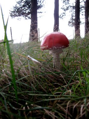
We see a perfectly formed red toadstool (fly agaric) which demands its own photograph then prepare to emerge into the open.


As always at this point, and I do mean always, it has started to rain. I don't think we've ever been to Hope Cross on a perfectly clear day. So since I have to down the rucksack (yes, I'm still carrying it) to get out my waterproof coat I fetch out the Secret Flask too. The Ramblers' Restorative does just what it says on the Flask. A couple of nips each and we're raring to go - after we've clambered over the two stiles.


Someone has left some yellow flowers on top of the cross which look very cheerful in the midst of the drizzle and low cloud. I go around the high wall to study the cross. It is dated 1737 with its four sides signed Shefield (yes, one f), Edale, Glossop and Hope. It is believed that this is a restoration or a replacement of an earlier cross.


The flat topped cross sits next to the ancient roman road which ran from Glossop to Brough and which is still, in places, a path. Here is one of the heavily used stretches and it has been said that, at certain times, roman soldiers can still be seen marching here. Never actually seen them ourselves, so we can't substantiate this!


We walk along the side of the path keeping between the high wall and the tree line to protect us from the rain. There are more walkers out on this side of the hill, though not a large number. Soon, though, the rain stops and we discover that we should have walked on the path this far, as we've come up against a no-stile. Basically, there are some fencing rails and a gap where the step should be. PC curses as she climbs over it, damning it as the worst stile in the Peak District, although she'll probably reallocate the title elsewhere in the future.


It's up and down underfoot next to the treeline, but we shun the well trodden path because we're a bit perverse like that. We do see a lot of fungi, though, ranging in colour from sickly cream to deep burgundy, and do benefit from shelter provided by the wall. Some of the sheep give us odd looks, but they're sporting purple splodges on their fleeces so they've no need to stare!


By the time we're in sight of our turn-off back down into the woods we're more than ready for our lunch, and fortunately there are enough tumbled sections of wall to provide somewhere comfortable to sit.


It's nice to get the rucksack off (yes, I'm still carrying the rucksack) and enjoy a cup of coffee. PC's made a good flask of coffee today (even though I've carried it all the way here) and as the first cup is downed the sky looks as though it might manage to clear. After the coffee we eat our sandwiches (yes, carried them too), have a second coffee, then fetch out the buns.


Mr Morrison has provided puff pastry fresh cream mince pies for us today. They're 'new', a welcome precursor to the Christmas season (unlike the infernal jingly songs blasted out in every shop and supermarket at this time of year which are only guaranteed to make goodwill to all men evaporate at super speed). The mince pies go down extremely well, and are washed down by the final dregs of coffee. At least when the rucksack is packed it is much lighter.


From here it's going to be pretty much all downhill. What a pity then that the path (a Footpath, not a Bridleway) has been churned into a slippery mess by mountain bikers. We pass two on our way down, but they don't seem even slightly ashamed that they are on a footpath and shouldn't be there.


The second part of the path through a young conifer plantation isn't nice to walk on; stony, rutted and churned in the centre, slippery at the edges. But when we can look up from where we're walking the views opening up across to Crook Hill are superb. The cloud has lifted and although the sun isn't shining at least it is clear.


We turn right on the broad track which contours the hill so remains fairly level, and since the trees to our left have been cleared we can see the patchwork woodland on the opposite side of the valley. Narrow lines of russet and pointed triangles cut through dark green blocks to make geometric shapes. We could make some interesting mathematical questions using the shapes - how many trees will you need to fill a space the size of...maybe not.


The path is a little soggy in places with one or two puddles, but we haven't walked too far when it suddenly changes and becomes a gouged hollow in the ground. Clearly diggers have been cutting a deep track though why the cut needs to be so severe is a mystery to us. From hereon we are walking below ground level on muddy (sometimes extremely muddy), stony ground. It isn't particularly pleasant as we have to watch where we're putting our feet as opposed to enjoying the view and when it starts to slope down we have to be doubly careful.


At one point, where a stream discharges on the track, we have to do a balancing act on a log to avoid being sucked into the mud. The potential for humour or disaster are great, but both are avoided. Eventually the path nose dives and takes us down to the broad path that skirts the reservoir. Now all we have to do is walk back.


We've made good time, but the clouds are gathering again and the light is fading. As we approach the path to the dam wall there's a biker repairing a puncture. Poor guy, hope he hasn't far to go afterwards or he may be caught out.


We're soon across the dam and back to the cars. I take off the rucksack and hand PC her flask (yes, I've carried it all the way and no, I won't let her forget it), but we don't have time to linger. Next week's walk is already planned so we're into our cars and away before the dusk swallows us up.