Stanage

Thursday, 25 March 2010

STANAGE EDGE


Rain and wind were forecast with the dull skies underlining the likelihood but as we met at the car park the promised rain had yet to make an appearance even though the cold wind was making itself felt.

This familiar walk holds no surprises for us but is one of our 'hot chocolate and fluffy blanket' walks. Familiar and comforting.

We decided on the easy route up to the ridge - a short trek up the road past Overstones Farm, left onto the footpath then onto a track that led us up onto the ridge with minimum of effort. It's a wide view from here: the flat, sky filled vista over Friar's Ridge stretching north towards Bradfield, Penistone and beyond; Higger Tor to the south managing to look unimpressive from this angle; Stanage Edge sweeping north-west but not wholly visible from here.


The ground is distinctly soggy underfoot thanks to the downpours of the last couple of days which have left the peaty ground sodden. Thank goodness for the huge stepping stones over the worst ground.


We hop up to the trig point at 457 m like a pair of (not so) agile mountain goats and admire the view. Pity the cement works at Hope intrudes, its pale grey geometric outline alien in this rugged landscape devoid of right angles or straight lines. But we manage to filter it out of our vision whilst listening to the birdsong, too many species to recognise are determined to let us know that they are feeling spring fever!


From the trig point we amble along the familiar ridge discussing, courtesy of a current television series, the planets and physics. Just goes to prove that we aren't entirely frivolous.

There's hardly anyone else up here. It's probably too early in the day, too dull and too windy. But this is the beauty of being able to walk mid-week, avoiding the hoards that descend on the Peak District at weekends. You can't blame them, everyone must make the most of the free time they have, but we appreciate our good fortune and enjoy the area without too many human distractions.

We pause at various points for photographs and scan the distant moors, naming them, recounting our numerous walks over them, planning on revisiting some. We don't hurry along desperate to clock up the miles. That would be missing the point. We have to stand and stare, it would be wrong to do otherwise.

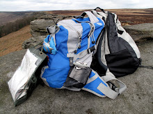
We stop for coffee after making the rucksacks pose for photographs and try to identify a very loud bird. No luck with the ID, perhaps I need to put a wildlife book in my already overstuffed rucksack.

A little way along we make a slight detour between two boulders, scramble back uphill then find a suitable rock to bask on and eat lunch as the sun makes an appearance. Yes, contrary to the weather forecast, it is turning into a fine day. Lunch has the tempting accompaniment of a small bottle of vino (early birthday celebration) which is savoured from plastic cups before the buns ('low calorie' fresh cream doughnuts) are devoured with unseemly relish. No rush. We sit and enjoy the views whilst putting the world to rights.


There are more people out now, mainly on the paths below the ridge, but the few that pass behind us don't intrude with anything more than usual walkers' greetings.

Rucksacks are shouldered again as we meander on, this really is a leisurely walk. There's plenty of water coming from the area known as White Path Moss and the many streams cascade over the gritstone edge as weak windblown waterfalls. Standing above them we are treated to a few drops of spray being blown back up at us, but we've been here before in fierce winds when we have been liberally doused by the water being thrown back. A water-rise rather than a waterfall, maybe?

We descend from the edge on the path down towards Dennis Knoll. Sadly the lane is badly eroded and eroded due to, in part, its use (overuse) by 4 x 4 vehicles whose drivers use the route for 'fun' whilst ripping up and polluting the countryside. Near the bottom of the track wide puddles extend across the whole width of the path with deep water-filled ditches on either side. Water runs from one side of the path to the other (the map says it's a ford but it hardly merits the description). To our surprise (OK, horror) we discover that the puddles are full, really full, of frog spawn. On closer inspection we see that the water-filled ditches are equally filled with the globular goo. With terrible fascination we envisage what it will be like here in a few weeks time - and vow to avoid the place for a while.

Our return by road is easy walking, not too much traffic and a fantastic view of the edge with an early moon hanging over it in broad daylight. There are lots more people on the top now, and a number of hardy souls climbing too. The running water beneath Sheepwash Bank is a tempting distraction but we must explore this another time.

The toilets provide a convenient break before we set off the up final hill alongside Cattis-side Moor. We maintain our pace all the way up and don't stop once. Not bad!


The car park is almost full with many people coming off the edge and others only just setting out, but we know we have definitely had the best of the day.




Friday, 12 March 2010

DERWENT


Our walk today on the side of Derwent has a specific purpose. Paparazzi Cate's father-in-law, Grandad John, passed away last week. He joined us on this walk a little over two years ago on a day as clear and sunny, but not so cold, as this. We strolled along at a gentle pace enjoying the walk, the views and the conversation. It was the only time I ever met him, but my lasting impression was that he was a gentleman. We walk this way today in his memory.
* * * * *
With immense good fortune, which we never take for granted, the day is as bright and clear as we could have hoped. The early frost has melted to leave us with a perfect walking day.
The toilets at Fairholmes are the prerequisite stopping spot before parking up at the side of the massive towers and hulking wall of the Derwent Dam. There is no one else here, yet. The air is deceptively chilly so we layer up before setting off, looking at least two dress sizes larger than is the case!
We pass the memorial to Tip, a faithful dog, and cross over the cattle grid. At the far side we pause to watch a squirrel bounding through the undergrowth as though its little legs are made of springs. It pauses behind a tree, watching us watching it, before it scurries away out of sight.
Although we have to walk on the road for a stretch it is no problem at this time of day. There is little traffic, although later in the afternoon the drivers will be out in their droves and those who are not too good at reversing will regret coming this way.
Looking back at the dam wall from the rear view it is impossible to see what is holding back the water, its level is so high. Another few inches (probably millions of gallons) and it will cascade over the top - always a sight worth seeing. But the reservoir itself is covered with grey ripples and deep shadows, ominous but compelling.
Once we pass Gores Farm we can walk on the edge of the wood that sweeps down to the reservoir, although we have to be careful of knobbly tree roots that twine beneath the path with the special intention of tripping up the unwary. A short way on we can see, through the trees and along the length of Derwent Reservoir to Howden Dam. The view is beautifully framed, as though the position was chosen by an artist rather than an engineer, and today it is especially magical as we can see water pouring over the dam like a sheet of lace. Close to it will be extremely loud but from this distance it is quite tranquil.

It doesn't take us long to reach the bend in the road which was the end point of our previous walk. Today, though, we have arrived here much too soon so we consult the map and decide to head west through a gate heading for access land to see what we can see. We've never been up here before.
The first part of the track has been surfaced with chippings for the forestry vehicles, but it doesn't prevent the valley having a totally different feel to its larger neighbour. It's quieter (no logging today) and has large pockets of native trees around the stream. Some of the trees - both native and coniferous - have boxes on them, possibly for bats since we can't see any holes. It is good to think that wildlife is being given serious consideration in a managed environment.
We soon reach the end of the 'road' and set off across rough ground littered with the remnants of felling. We have a wide stream to cross, and we have decision time. Do we go left and follow Alport Grain or take the right fork along Ouzelden Brook? Alport Grain wins: it's lighter, brighter and in the open whereas Ouzelden Brook is through conifers and looks seriously boggy.
First we have to cross Ouzelden Brook where its banks have kept the sunlight from the water and left the shaded grasses weighed down with heavy globules of ice.
At the far side is a stretch of dry stone wall, very old but redundant now. Its smooth flat stones are red tinged beneath heavy encrustations of moss and lichen. Close by are some tall, old trees standing guard over Alport Grain (we're still debating over the species) looking very imposing and special despite being hemmed in by ranks of conifers. At least some new native trees have been planted, their spindly forms cocooned in protective plastic tubes.
We're forced to scramble as the path (what path?) becomes indistinct (nothing new there) and then we have to cross Alport Grain to avoid a bog (recurring theme). At this side we meet another old tree, a broad trunked silver birch which must be nearing the end of a long life, its thick roots clawing upwards in an attempt to cling onto the bank. Its fallen companion lays at its side, no doubt providing refuge for small creatures and mini-beasts.
A little way upstream and we have to cross over again and negotiate our way up the suddenly steeper opposite bank. Hands and knees are employed, dignity is abandoned.
We are beneath the rocks on Birchinlee New Piece and as we walk through the deep grass and dead bracken we find a couple of pockets of snow glistening, but not melting in the sunlight. Hardly surprising, there's an icy breeze blowing down the valley.
It's lunch time and we find the perfect boulder it sit on; low down enough to be beneath the breeze but with the sun on our backs and the sound on water nearby.
We empty the secret flask and make a toast before fetching out lunch and the buns. Fresh cream lemon muffins. They look wonderful. Paparazzi Cate says they are. I don't know. I have a cold and can't taste a thing.
We sit a while and as we do a buzzard soars overhead with a lazy flap of its wings. We've seen them around here before, usually up the valley, so we wait hoping for another sighting. Our patience is rewarded when we see two more over Bellhag Tor, one of them quite a size.
It's too enticing sitting here so we force ourselves to pack up and head back, detouring slightly to avoid the acrobatics by the stream. The slight change of route opens up a whole new vista so we hurriedly scramble upwards to a vantage point and wow! We can see beyond the reservoir and Abbey Bank to where Howden Edge and the Howden Moors are covered with huge dollops of snow. It's lovely up there, but we wouldn't fancy it today. Much better to enjoy it from here.
We back track along our outward route to the cars, but know that we'll be back. We want to explore the route of Alport Grain and see if we can get up onto Pasture Tor and Bellhag Tor to make a circuit.
But for today we have achieved what we set out to do, and remembered our last walk here with a gentleman.

Friday, 5 March 2010

CURBAR EDGE to WHITE EDGE


What a difference a week can make. It's almost springlike with the sun shining out of a clear blue sky, and even though the temperature has only managed to creep a couple of degrees above freezing it feels much warmer. On Curbar Edge weather-worn hollows on the tops of the gritstone boulders hold pockets of ice shimmering in the unaccustomed sunlight. The fine weather has brought many people out although they are all, like us, muffled up against the chill that bites hard on this exposed edge.

We pace ourselves along the long stretch of rock, not wanting this tantalizing but entirely false sense of freedom to be over too soon. The bright sun on brooding rocks brings everything into sharp relief and the views, as usual, are outstanding. It never fails to surprise us how far and how much we can see. Our horizon is taken up by the distant bulks of Kinder Scout, Bleaklow and Howden Edge all liberally covered with snow and looking magnificent. Closer is the long length of Stanage Edge - a familiar haunt of ours - with its rugged cliffs looking as though they have been buttressed with columns of snow. Here, thankfully, it is clear! Sadly, we won't have spectacular photographs today, Paparazzi Cate has 'the wrong lens'. Never mind, we'll make the best of it.
We amble along following the undulations of the ground until Paparazzi Cate slips on a slight downward slope and falls with a definite squelch. But it's OK. The buns in her rucksack are safe. She had heroically protected them as she fell. That's dedication for you. Of course, now she tries to hide the soggy, muddy patch on her behind without much success, it's there for all to see. Wish I had the camera!

The path on top of Curbar Edge is easy to follow as it runs along to join Froggatt Edge. We decide to keep on walking until lunch beckons, then backtrack to where we can drop down to the lightly wooded lower slopes below and then return to the car.
However, inspiration strikes when we see an indistinct track off to our right near an old field enclosure and we set off across open land towards White Edge. The path becomes ever more obscure as we press on. An old wooden post, probably the remains of a disappeared fence-line, carefully nurses a tiny bilberry plant in a pocket of rotting timber. The plant seems impossibly fragile in this harsh landscape.

We're alone now apart from two sheep who act like escaped convicts, eyeing us suspiciously then sidling away. All the other walkers are on one or other of the edges, and we're traipsing across the rough moor in the middle. We feel almost intrepid as we negotiate tussocks of dried, bleached grasses and ice-encrusted bogs.

As the land dips we know that our progress may be impeded, we spy reedy grasses and know that we'll hit water soon. We hear it before we see it, although we've already found the peaty bog that accompanies the moorland stream. But before we venture knee deep into the mire we see a safe crossing place a little way upstream where we are able to leap gazelle-like (!!) across some boulders.

Still dry shod we arrive at a small copse of trees with sheep-cropped grass beneath. The sun is shining on a large flat boulder which positively invites us to sit down. How could we refuse?

Lunch is eaten enjoying the solitude and silence. Coffee is drunk, a cheery nip from the secret flask consumed and the buns (fresh cream doughnuts) are brought out. They were, apparently, the lowest calorie buns on offer that day! No matter, every calorie is savoured.

White Edge is in our sights so with our energy stores suitably replenished we forge ahead without even a hint of a path to follow, and arrive exactly where we want to be. Amazing! We have a steep uphill pull onto the Edge but we're there with relative ease - the doughnuts must have helped - and was the effort worth it? Definitely. The extra few metres of height up here make all the difference. Sure, we lose the views of the valley bottoms but the distant panorama has widened out.
All that remains is the traverse along the edge, the path much narrower here than on Curbar Edge but no less distinct, passing many more walkers and the stark, white trig point at 365m. We descend, turn right around the field boundary and go sharply downhill, negotiating a muddy bog and the even muddier Sandyford Brook before climbing up to the road and back to our cars.

As we sit on the back of our cars removing our boots we look up at the cliffs of Curbar Edge. Maybe it's a trick of the light, but staring down at us are some Easter Island Heads. Next to them is a bear. The heads are photogenic but the bear refuses to be captured on film.


With the photos taken we round off a wonderful walk on a wonderful day and keep our fingers crossed for next time.